Day 84: Mecan River Segment (Part 2), Waushara County
Day 84: Sunday, August 1st, 2021
Total Miles covered for the day: 3.0
Location: The Mecan River Segment between the middle intersections of the trail with 9th Avenue and the southern trailhead on Cumberland Avenue, then between the parking area on GG to the north and the parking area on 9th Avenue to the south.
3.0 miles of trail covered.
Yesterday we hiked the tiny, little loop of trail that juts out from 9th Avenue with our daughter and her dog, and today we came back to see how much more of the segment we could complete.
We got kind of a late start this morning, and weren't in any great hurry. The weather forecast was hot and muggy again, and if it was anything like yesterday, we knew we were in for a long day today. It didn't turn out anywhere near as hot, but it was still muggy.
As we drove up to our intended drop point for our target vehicle on 9th Ave, we happened to notice two fully-geared hikers walking on the road, headed for a bench near the river. Always nice to see other hikers, we thought, and then we turned and headed up the road
First, we drove our target vehicle to the southern trailhead parking area on Cumberland Ave. That's the road that just north of Cumberland Ct, which itself is a little north of Cumberland Rd. This, by the way, is a systemic and mind-bogglingly frequent situation in Waushara and Adams Counties, where the same road name is used again and again and again, often using different suffixes like 'Road' and 'Avenue', but not always. The sheer number of roadways containing the word 'Czech' in this region defies all explanation.
But enough of that.
Then we drove our launch vehicle back up to where we left off the day before, on 9th Ave. There are three places where the trail intersects 9th Ave, and the two southern ones are easy to miss. Even though I had actually walked out of the woods there the day before, I didn't see it as I blew past and only knew where I was because I saw a familiar parking area. We parked at N 44 02.275, W 89 26.735 and started our hike. It was 1:00 pm and 73 degrees. So far so good.
 |
| Sky Selfie |
The first four tenths of a mile were along 9th Avenue, and this proved to be level, easy walking. The temperature was actually still quite mild, but there was the oppressive humidity again, falling just short of the day before where I literally fogged my glasses getting out of the car. Today was just the normal kind of humidity that left you wanting a shower and a FULL change of clothes after only a couple of miles.
But enough of that.
When we got to the location where the trail cuts east off the road again we almost missed it, because we were so busy craning our necks gaping at all the bric-a-brac in the farmyard directly across the street. Had I not known that I was looking for just such a cutoff I would have missed it for the fourth time, having passed it three times already in the car. Fortunately, we saw it and started down this lovely 0.3 mile path along the Mecan River, which was our first real trail hiking of the day.
There was really nothing to tell about this segment, except that here we first spotted poison ivy along the route, which had been absent in the tiny piece to the north. Then, when we came out of the woods onto Hwy 21, we saw that the two hikers we had seen earlier were still relaxing on the bench by the river. We walked on over to chat.


"Hello!" Theresa offered as a first volley.
"Hey!" the woman replied, "Are you the woman who hates hiking?"
Busted.
I should explain. Theresa recently authored a number of posts in several Facebook pages and groups saying how much she hated hiking, and especially how much she dislike hiking the Ice Age Trail, which is often more difficult in elevation and trail footing than she would enjoy. The posts were meant to highlight the real struggles of the trail faced by an overweight and non-athletic senior and explain why, when there are so many things she didn't like about it, she continued to hike the IAT and has set the goal of covering the whole trail.
The Facebook posts got quite a lot of attention. A lot of Likes and Loves. A lot of people who found her honesty refreshing and even inspiring. She received a lot of encouragement.
Then she was contacted by someone who wanted to write up the story in the local paper, the Wausau Daily Herald. Two weeks later, the story was published, and more attention was received. The posts and the articles included links to this blog, and our readership increased exponentially, at least for a bit.
Then the article was picked up again and rerun in local papers all over the state of Wisconsin. The phone started ringing. Theresa had become the "Woman Who Hates Hiking". Here, in this small quiet sandy parking lot next to a clear-running stream, she was recognized and greeted by this new sobriquet.
The two hikers went by the names 'Sunny' and 'Captain Chaos', and they were delightful. They told us a little of their story. "You caught us on Day 1", they said. They were planning a 38-day adventure, walking the trail from the center point (somewhere north of the Mecan, apparently) to the eastern terminus.
They told us that they were staying in the camping area in Coloma that night, and had secured camping places each night along the trail, sometimes arranging to stay at a business overnight, out on the lawn. It took a lot of organization, Sunny told us.
We gave them some of our wisdom from hiking, starting with an admonition to stay clear of the poison ivy, and pointing out the large patch of it not five feet from where they sat. From the strange silence that followed, I could tell that my warning probably come too late.
Before we parted, Theresa gave one last bit of advice regarding properly fitted footwear, and how they should listen to their feet to make sure they don't do long-term damage in their ambition. Theresa took one more look at the trail signage, then we headed south.

 |
| White coral mushroom |


We got to the trailhead at about 1:50, and we were ready for the next piece, a little more than double the length of our first stint. Driving to reposition the cars we once again spotted Sunny and Captain Chaos making their way into town. We asked if they wanted a ride, and they declined, telling us it was 'only five miles'.
I guess on Day 1 they still felt like an additional five miles in a full pack was not a problem. I'm thinking by the time day 15 or 20 rolls around and they're trying to hike 15-20 miles a day, they might be more willing to accept a five-mile ride that has nothing to do with the IAT. Knowing the storms that came through during the next week, I often think about them and wonder how they are doing. By now they should be somewhere near Janesville if all is going well.
We repositioned our cars for a second leg, taking on the 2.1 miles between GG and 9th Ave. Starting at the north end at 2:11, the first thing we saw was a downy woodpecker hammering away at the tall bug-filled flowering stalk of the mullein plant. Here, in the bright sunshine and ridiculous humidity, the persistent 73 degree temperature was almost irrelevant. It felt like 85 and then some.
Then we started walking and discovered that we were about 300 feet from the actual trail, and needed to walk the short blue-blaze spur trail until we got to ticking off the miles again.


Back when I was a kid, and by that I mean more than 50 years ago, I remember taking a number of camping trips with my family to the Mecan River, where we would set up tents and spend a week in early May fishing for elusive trout in the clear water. I don't remember catching many trout, but I do remember many a campfire, and many a happy day spent enjoying this very river.
As I walked, I kept a vigilant eye out, trying to spot the place where we camped, driving our blue station wagon loaded with five people, two dogs and all of our camping and fishing gear. We haven't finished hiking the whole segment yet, but so far I don't think I've passed it. Of course, after 50 years, everything would look different. I may never know.
Along the way, though, I also spotted odd debris on the trail. I bent over to examine it and discovered that it was Hazelnut season, or at least that's what the squirrels believed. I looked around, and sure enough I could spot hazelnut bushes with their green, pod-like nut clumps hanging below.
 |
| Hazelnut leaves |
 |
| Hazelnuts |
Hazelnuts, also known as filberts, are sticky and generally unpleasant to touch, at least this early in the year, but as soon as the squirrels start to eat them they are technically edible. This is the flavor you'll get in hazelnut creamer, which just happens to be my favorite.
I also found this new plant species I had never noticed before.

 |
| Roundhead Lespedeza |
And a new flower for my collection, the winecup.
 |
| Winecup |
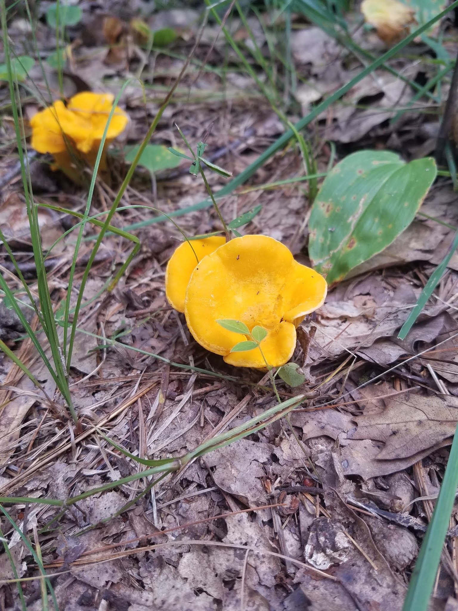
As well as these abundant yellow mushrooms I have yet to identify.
At last we found ourselves back in the woods again, and after another quarter mile or so along the hilltop the trail descended down a rare hill in this segment, dropping about 50 feet in elevation before flattening out and eventually making its way to the parking area. It wasn't far, and it wasn't even all that hot by the thermometer, but this was about all we could handle for the day. It was 3:50 pm, and we had a long way to drive before we set up our campsite for the night.
Running Total: 588.1 miles of trail covered; 66.5 miles 'extra' hiking/biking. End of Day 84.
No comments:
Post a Comment