Monday, May 31, 2021

Day 70: Chippewa Moraine Segment (Part 2), Harwood Lakes Segment (Part 1), Chippewa County

Day 70: Monday, May 31st, 2021

Total Miles covered for the day: 4.0

Location 1: The Harwood Lakes Segment, along 167th street. 
0.2 miles of trail covered

When we started out today we had no intention of hiking the Harwood Lakes Segment. In fact, until we got home, and even until twelve days later, we didn't realize we had, in fact, hiked a small portion of the Harwood Lakes Segment. We were simply looking at the map, driving to the parking area where there was a trail sign that said "Ice Age Trail", marking what we thought was the start of the Harwood Lakes Segment, and hiked the opposite direction. 

What we didn't realize was that The Harwood Lakes segment actually runs for a short distance along 167th Street until it meets up with the Chippewa Moraine Segment. 

This certainly didn't add much distance to our hike today, but I can say that there was more scenery in those 0.2 miles of roadway that many other connecting routes have in their entire multi-mile repertoire. 


Before we knew it (literally) we were on the Chippewa Moraine segment, as intended.

Location 2: Eastern end of the Chippewa Moraine Segment, between 144th Street to the west and 167th Street to the east.
3.8 miles of trail covered

As I mentioned above, I don't really know what time we started hiking the Chippewa Moraine segment today. Since we started at the Parking area on 167th Street at 11:45 am, I'm sure 12:00 noon is close enough. And the temperature was probably still 64 degrees. 

The parking area, I should note, is on the east end of Plummer Lake, and features a boat launch and a horseshoe drive-through that I don't recommend for most vehicles. In fact, if you're not driving a truck I recommend against testing the drive-through. There are rocks that will tear out your undercarriage and a pond in the roadway, the depths of which have never been charted. We actually didn't park right there because there were four or five other cars there, making the most of their Memorial Day. We ended up parking on the roadside up by the Trail Sign, which worked out just fine. 

But back to the hike. 


When we left 167th street, the trail took a brief stroll through a charming corner of woods between Plummer Lake and 260th Avenue, otherwise affectionately known as Rattlesnake Hill Road. For those who think that Wisconsin doesn't have rattlesnakes, please think again. Though neither the timber rattlesnake nor the eastern massasauga can be considered common in Chippewa County, it is not so far outside the native range of these two snakes that it would be impossible to see one. And there is no question this road got its name from somewhere. 


This took literally only a few minutes, but when we got to the road we were able to enjoy watching the landowner on the corner working with their horses for a bit. 

Then we walked up a fairly steep bit of road that gained us more than 50 feet in elevation before the trail cut north into the woods. Then the woods gave way almost immediately to wide open fields, where the trail was discernable, but only just.


A tenth of a mile later and we were at the large parking area that sits on 260th Ave., but we just kept going through the gate and up onto the top of an ice-walled lake plain where the narrow single-track, which was covered in horsey hoofprints, ran between a close gauntlet of prickly ash trees. 


And no, we have not become so good at spotting glacial features that I recognized this fairly open field as an ice-walled lake plain. I knew this because there was an old ratty sign that told me so. 


At the very apex of the hill was a bench, with a somewhat obstructed view of faraway Dumke Lake. We sat there for a while, because there were no flies, the weather was sunny and warm, and it was Memorial Day, after all, so we used some of our holiday time for relaxing.  


This section of trail, by the way, was beautifully marked, and even included orange spray paint on the ground that literally marked almost all of the stubby little tree stumps that stuck up, or roots that were a little too high. We briefly discussed what those marks were for, and we finally concluded, accurately enough we later discovered, that they were put there so that someone else could come through later with appropriate tools and remove them. They served the double-purpose, however, to make hikers aware of them so as not to trip.
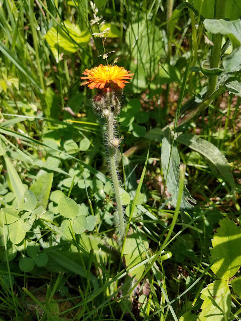
Fox and Cubs

I've said it before, but it bears repeating. The local chapter of trail volunteers for Chippewa County are the best we have met anywhere, and they work very hard to make the trails as inviting and manageable as possible. That's why we knew those marks were put there as a part of ongoing maintenance, and we confirmed it when we talked to them 12 days later. 

They also do a phenomenal job of putting up trail signs, though to be honest I could use a few more plain-old yellow blazes in the woods, too.  


 I was walking along the trail one day, and I happened to see a frog sitting in a crabapple tree. 

"Hello, Mr. Frog! How are you doing today?"

The frog said nothing.

"Are you enjoying the warm weather?" I asked.

The frog said nothing. 

"How long have you been sitting here in this crabapple tree?" I asked. 

The frog said nothing.

"Well," I said, "I want to thank you for sitting here and making today just a little bit nicer for us."

To my surprise, the frog answered, "You're welcome."

Astonished, I said to the frog, "I didn't realize you could talk! I am curious, though, when I was asking you those questions before, why didn't you answer me?"

"Because," said the frog, "When you were asking me how I was doing, if I liked the weather, and how long I had been sitting here, you were speaking to me as though I was a lesser creature who couldn't possibly understand you."

"And why did you finally answer me the last time?" I asked, puzzled.

"Because when you spoke to me the last time, you were accepting me for exactly what I was, and thanking me for being an important part of this world. It was only when you started treating me as an equal that I also started treating you as an equal."


Once we crossed 160th street the trail ran uphill for a bit, then across a grassy and mucky hilltop before turning into a much nicer single-track through the woods. This all occurred in a span of about a quarter mile, and one of the things we noticed was all the dragonflies that were out.

And lest anyone ever get the mistaken impression that dragonflies are just cute little things that buzz around and don't do much, let me tell you that they are absolutely the winged piranhas of the insect world. Though their primary diet is mosquitoes and midges (I knew I liked these things for a reason), they will also eat almost anything else that is within their weight class or less, including other dragonflies. An adult will eat it's own body weight in other insects every day.

And I got the distinct pleasure of watching one capture a horsefly and make a ridiculously short meal of it. I'm sure if I was watching this at a macro level the imagery would have been horrifying, but on the 'You go, dragonfly!' scale, it was kinda cool.


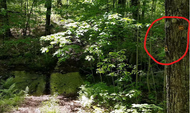
About the time we reached the point where the trail bumps up against Horseshoe Lake, we saw this sign.


This is what made us realize that for the last six tenths of a mile or so, we were walking on brand new trail that had been so well constructed we could hardly tell it was new. This also explained the orange-painted tiny stumps, because the fact that they were there at all was completely inconsistent with how well this group of volunteers maintain their trails. 

I have it on good authority that the orange-painted stubs were removed about a week later. 

I didn't walk down to see the bridge that was no longer usable, but I wish I had. Horseshoe lake was a pretty spot. 

The next two tenths of a mile were a very pretty walk along Horseshoe lake, and we paused briefly to sit on a log and enjoy it. 


While we sat, we were passed by two young men out for a 'quick hike', who asked us if we knew what lake this was, because they were hiking without maps, and without any particular means of knowing where they were. Strangely, I happened to know it was horseshoe lake because of the sign, and they said that they had started at the Interpretive Center and were doing an out-and-back hike and weren't sure how far they had come. We told them they had come somewhere just short of five miles, and made sure they had water to drink. They assured us that they were fine (it was clear they didn't have enough liquid, but it's hard to be pushy in that situation), and then we saw them again as they passed us on the way back. Young and in a hurry, it seemed like they wanted to hurry up and get the hiking done before they got onto their next adventure. I'm thinking they'll learn to slow down a little in the next 30 years or so. 

The trail continued as a well-worn dirt single-track under a canopy of mostly oak and maple. What we really enjoyed was all the wonderful birdsong. These woods are absolutely full of birds, and they are happy to let you know about it. 

As the trail turned north, we encountered more of the same, crossing between two lakes on a steep descent. Right at the saddle, where we started hiking back up the other side, I could see an informal campground on the west side of the trail that seemed like a right fine place to camp, if you're looking for one. 


The next zig-zag went to the south again, so as to walk around the southern end of Dam Lake. 
The trail here is unrelentingly pretty, and fairly easy to walk. So much so that I don't really have anything to add except that it was more of the same beautiful trail. 

At Knickerbocker Lake we finally encountered another bench where we could sit a while and enjoy the weather. There were steps leading down to the water's edge, and it was only when I walked all the way down to the lake that I noticed the small bit of civilization across the lake in the form of a lake home. I didn't mind - the lake was big enough to share.


As I sit here now and think back on the last nine tenths of a mile I have almost no distinct memory of the trail, and almost no notes from the hike. I know we passed two more ponds, I know I took a few more pictures, and I know that the hiking was extremely pleasant. I'll let these three photos speak for themselves. 


Prickle Tree Clubmoss


When we reached our car that was waiting for us at 144th Street it was 4:04 pm, and the temperature had climbed to a surprisingly warm 73 degrees. Thank goodness we were in the shade most of the time and there was a decent breeze.

Looking towards our car that was pulled over alongside the road near the trail sign, we noticed some paper stuck beneath our windshield wiper. 

"Are you kidding me?" I said, not at all sure who would leave us a nasty-gram for parking here, or worse, give us a ticket. 

Instead, we found a note from our recently acquainted friends, the 'Pointer Sisters', whom we had met the day before up on the Tuscobia Segment. 

11:11 am - Hello from the 3 gals from Stevens Point, now known as the "Pointer Sisters". Headed towards 267 😀
(meaning 267th Ave at the far end of the segment). 

Oh, how delightful it would have been to have seen these three ladies again, but alas they were hiking the same direction we were, and they had started where we ended. We double-checked the time. "11:11?!?" We only missed them by five minutes. Somehow, they had remembered and recognized our van parked there, 45 miles away from where we had seen them last and were kind enough to leave us a note. 

Liked your blog!

When we met them we asked to take their photo for our blog and gave them the name of it. Apparently they had gone out looking for it that evening, but sometimes it takes me a week or two to get around to completing the posts for any given hike. I sincerely hope the Pointer Sisters came back and found their blog photos.  

Running Total: 483.6 miles of trail covered; 40.2 miles ‘extra’ hiking/biking. End of Day 70.

.
.
.

.

Sunday, May 30, 2021

Day 69: Tuscobia Segment (Part 2), Washburn and Barron Counties

Day 69: Sunday May 30th, 2021

Total Miles covered for the day: 8.4, plus 0.1 miles extra hiking

Location
: The Tuscobia Segment, between Balsam Lake Road to the east and 21st Street to the west. 

We've been doing a lot of hiking over the last 30 days. And the conditions have not been ideal. We've had rain, we've had snow, we've had frost and muck. We've had temperatures down to 25 and up to 90 degrees. It's been quite a month. 

Today we decided to 'take it easy' and hike the rest of the Tuscobia Segment. We had already hiked the 1.9 miles on the west end, and the 0.9 miles on the east end, leaving the 8.4 miles in the middle. This was longer than what could be considered an 'easy' day for us, but on the other hand, the walking was straight, level, and, for the most part, totally muck-free. 


But as you can see from the above photos, it's not completely grass-free. 

We decided to chop it in pieces starting from the northeast end near Birchwood, so the first thing we did of course was to drop a car where we left off when we hiked the old Blueberry Segment, which has now been annexed into the Tuscobia Segment. 

Good ol' Blueberry. I remember it well. 

Then we drove down to County Road T, in the imaginary town of Angus, and started hiking northeast at 9:15 am. It was only 53 degrees, which was great, and we were traveling light, without the backpacks. 

If there is anything you could call the 'hilly' section of the Tuscobia segment, this is it. Yes, true, it is laid on top of what used to be a railroad bed, but not all aspects of the new trail remained level and straight. Here, in particular, it's almost like the railroad was never there, and we had to hike up and down a few times on a rather terrible surface because part of it is shared with Mules and ATVs. Where they run, the trail is stones and gravel, a far cry from the crushed gray gravel you'll find on most of the segment. 

Part of this mile or so of trail actually cuts off to the side of the ATV trail, but I could tell by the lack of footprints and the total lack of a discernable 'path' through the grass that most hikers just stick to the gravel anyway. 


The trail dips significantly where an old bridge had been removed, and we hiked across a second bridge that isn't immediately visible from the roadside, then back up the other side to the waiting car at 9:45 am. One down, seven to go.

What we also accomplished during that mile was to complete all trail miles in Washburn County, including Timberland Hills, Grassy Lake, Bear Lake (yes, Bear Lake - go look closer), Tuscobia and part of the connecting route on the way to Hemlock Creek. By the end of the day our plan was to knock off Barron County, too.

Have you ever seen this flower?


I'll bet you recognize it now! (Columbine)

Early Meadow Rue

For part 2, we parked our launch vehicle on 26th street, and started hiking at 10:15 am. It was still 53 degrees, and it actually felt just a little chilly because of the humidity. The path here was more what we expected, basically flat, straight, crushed gray gravel, and the view didn't change much. But the highlight of the day was crossing paths with three charming women who were hiking the other direction. 


We stood and talked with them for quite a while, asking about their adventures. I'm not sure what gave me the impression that they were serious section hikers, unless maybe it was their feet.


Don't let those disarming smiles fool you, boys! These three women were warriors of the trail in every aspect. They knew the ropes, and knew just what they needed to make each segment safe and comfortable.

"Where are you from?" we asked. "Stevens Point", they told us, and we shared that we were from Wausau, trying to close out our western gap. They were also section hikers, and had chosen the Tuscobia segment to hike that day, same as us.

We asked them where they had been the previous day, and they told us they were at the Harwood Lakes Segment in Chippewa County. We were, in fact, considering hiking that very segment within the next day or two, so we were interested in what they had to say.

"Ticks", was one immediate response. 
"Hills", came another.
"Kind of wet", was the third. 

It reminded me of the Three Fates. 

We told them about our method of hiking, and they told us that they had seen our vehicle.

I could have spent the entire day in the company of these three besties from Point, but alas, we were walking east and they were walking west. Finally we parted ways. It was the next day before I learned they had given themselves the nickname, "The Pointer Sisters" while they were hiking. I will ever remember them thus. 


We ended our part 2 hike at 11:15 am, and the temperature had dropped again to 52 degrees. Hiking this piece achieved the mini-goal of completing Map 10, so we celebrated that achievement with all the appropriate pomp and ceremony and went on with our day. 

For part 3, we drove down to Brill and parked in the Town Park near the excellent restrooms that were easily and publicly available, about 300 feet from the trail.

We started this hike at 11:45 am, and the temperature had dropped another degree to 51. This piece was a tiny bit longer, about 3.2 miles, and featured a couple of turns and some actual scenery. It also featured a very light rain, so we put up our rain hoods and kept on a-going. After Thursday's ritual drowning, this was nothing. 


We were amazed to see a  few trillium still displaying their white petals, though pink was far more common. 


Along this piece we passed several ponds, all enhanced by beaver activity. In one location in particular you could see where the beavers had blocked off a culvert. Though this was charming, in a way, it poses a real problem for those who are trying to maintain the trail. There was so much water building up on the uphill side that it is starting to threaten the trail itself. In a not too distant future it will start to overrun the trail and will definitely create some nasty washouts. 


Though it was level, straight, easy walking, this section did start to feel like it was  a lot longer than 3.2 miles. Even so, when we finally made the second major turn and made it to 26th Street again, the time was only 1:45 pm. For us, this was making pretty good time. I think it was the never-changing nature of the segment that was making our toes ache. Or else it was the miles. Either way, we were starting to drag our butts a little, and it was still early. But it had stopped raining, and the temperature had climbed to a respectable 55 degrees. 


Now - we had been hiking for days out here in the Rice Lake area, and every day we had been too late to partake of a special indulgence and go to the Norske Nook for pie. The restaurant closes every day at 4 pm, so rather than risk missing it again, we decided to take a break and head into town. 


The Norske Nook is renowned for one thing - award-winning pie. We have visited the Norske Nook a number of times over our lives, always before going to the one in Osseo, and up until today I would have said it was some of the best pie ever. Today, we got a slice of Chocolate Cream Pudding Pie and a slice of Lingonberry Apple. We were a little disappointed. 

But we didn't let it diminish our enthusiasm for completing the segment today.

Part 4 of our day was the last three miles of the segment, from 21st Street all the way into Brill. We could have cut it into pieces, possibly parking near 23rd Street or 22nd Street, since the trail crosses both of those, but we decided to just go for it. The day was getting on, and we didn't want to waste the time it would take to reposition the cars.

So we drove down to and parked at 21st Street, in the same tiny triangle of land cut off as the trail passes the corner, and this time headed east instead of west. It was 3:30 pm and the temperature was 54 degrees. 

This time, as we touched the sign behind us we were once again 'touching the river', the contiguous part of the trail we had already hiked that led all the way back to the western terminus, and we would be bringing it east with us. By the time we reached the car, that continuous highlighted line would extend from map 1 to map 12, almost all the way to Weyerhauser. 

The first thing we encountered was the 'blob'. From a long way down the trail it was difficult to decide exactly what we were looking at. Turns out it was just a pile of sticks someone had made during a trail cleaning effort of some kind. 


The most memorable thing on this part of the trail was being passed by four horses, two going in either direction. I learned something about horses and trails. The two that were traveling east to west were not wearing horseshoes, and they were hardly making a mark on the trail. Sure, they were leaving other obvious signs of horse-passage, but no hoofprints to speak of. 

The other two horses, the ones that came up from behind us moving west to east, were wearing horseshoes, and as they passed they were absolutely tearing up the trail where they walked. If I had been passing that way on bicycle, I would have been seriously annoyed at the horse-owners, especially since this was NOT a designated trail for horse travel. 

Along the way I passed numerous ferns, flowers, and lovely greenery. I also passed stinging nettles, poison ivy and giant hogweed, all of which should be avoided for different reasons. If I had also seen wild parsnip and poison sumac I could have named this the Australian Outback of the IAT. 

The very last thing we did before coming into town was cross over the Brill River, which is done on an fairly new wooden bridge built for snowmobile traffic. On one end of it was a rock with a strange carving on it. If you know what this means, please leave a comment.


A few minutes later and we were in Brill, touching the sign one last time for the day at 5:10 pm, temperature 54 degrees. As a bonus, we completed map 9, the Tuscobia Segment and Barron County all at once. 

Running Total: 479.6 miles of trail covered; 40.2 miles ‘extra’ hiking/biking. End of Day 69.

Saturday, May 29, 2021

Day 68: Northern Blue Hills Segment (Part 3), Rusk County

Connecting Route, Washburn and Barron Counties

Day 68: Saturday May 29th, 2021

Total Miles covered for the day: 7.0, plus 0.5 miles extra hiking

Location 1: The southern half of the Northern Blue Hills Segment, from Stout Road to the north to County Rd F to the south. 
4.6 miles of trail covered, plus 0.4 miles extra hiking. 

This was our second attempt to hike this section of trail. Yesterday we were planning on hiking this piece but wound up in the wrong spot for our drop vehicle so we adapted our plan and hiked the Southern Blue Hills instead. 

Today, though, I took a little more care in giving instruction to our GPS and ended up on County Rd F as we should have, so as to drop our car off at the intended end of the hike. There is literally NO parking at the trailhead, so instead we went about a tenth of a mile west and parked at what looked like a reasonable pull-off on the south side of the road. Then we drove back up to Stout Rd to the 0.3 mile spur trail we hiked two days earlier. 

One thing I didn't mention is that just as you're making the final turn to the large, gravel parking area you can see the remnants of a 1941 Ford Super Deluxe, color rust, dumped in the weeds and shot full of holes. There isn't much that remains intact on this once proud vehicle, having seen the ravages of time and neglect. It's actually a pretty good metaphor for the Northern Blue Hills segment. 

Today was a LOT different than it was two days ago, where we were dealing with cold, pouring rain. Today it was 58 degrees already, although that was at least in part because we were getting a much later start. After the punishing conditions we faced over the last two days were were less than eager to get started today. Nevertheless, we were geared up and ready for our hike at 11:30 am, very much looking forward to saying 'done' to the Blue Hills. 

The spur trail was a lot different today, too. The torrent of water was gone for the most part, leaving behind a seriously eroded mess. Walking was easier because it was fairly sandy and it drained well, but someone will need to put serious effort into reclaiming this road for drivability if they ever intend to use it again. 


The lake was gone at the bottom of the hill, too, so we had no trouble walking directly to the trail sign and getting underway.

The first part of the trail was a long, uphill stint that peaked out about a half-mile later at 1662 feet of elevation. It was the highest point on the Northern Blue Hills segment, and the Southern Blue Hills boasts one only slightly higher. The trail here was wide and grassy, with very easy walking and almost no mud. 


About a mile into the trek, as we neared the pond called 'Lake in the Hills' by the locals, we ran across this fine fellow.

Good camouflage

The lake itself has very black water, though that doesn't show up well in photos. 


The trail here cuts unnecessarily close to this small lake, creating a few problems. The first one, though, has been taken care of by placing these three logs across the muck as a permanent boardwalk, something so iconic on the trail as to have made it onto the pages of the 2020-2022 Edition of the Ice Age Trail Guidebook. 


After that, we had to pick our way across the mucky trail right next to the lake, or bushwhack a little bit uphill. This was poor route planning and could use a permanent move about 10 feet uphill. 

On the south side of the pond the trail rose rapidly, straight uphill, creating a very unfortunate washout that was 100% the fault of the IAT. This absolutely needs a re-route with a switchback, or a slightly different approach to the whole thing. 

Once we climbed up out of that gorge, however, we found ourselves walking along a gorgeous part of the trail that was mostly level, grassy, and with good footing, before we stepped onto an ATV trail that we followed for a while. 


About two miles into our hike, as we approached what I knew to be a river crossing, I looked straight downhill along this ATV trail we had been following and saw the trail plunging directly into and through the creek. 

It's a little hard to see from the photo below, but this is a fairly steep hill, and directly across the creek was the continuation of the trail on the other side. 


This was NOT the river crossing we had been hoping for. Now I am fairly adept at rock-hopping across streams, and Theresa had made an artform out of ignoring them and marching straight through, but I wasn't all that impressed given that there was no indication on the map that there was a ford involved. Plus, as we started up the other side we could see where the four-wheelers had absolutely torn the uphill track to shreds, gouging deep ruts as they clawed their way uphill through the mud. We got another 100 yards or so, avoiding what was suddenly very wet, puddled, muddy trail until Theresa and I realized just about the same time that we were no longer seeing yellow blazes. 

I went a little further down the trail, and came to the conclusion that something was definitely wrong. I needed to backtrack and figure out what we missed. And - after I re-crossed the creek to the northwest I very quickly spotted the blaze that was on a tree, 90 degrees to the left. We were so focused on getting across the stream that we missed not only the turn arrow, but also the yellow blaze. 

The arrows we missed


The Yellow Blaze we missed

In our defense, though, we are definitely NOT the first hikers to miss that turn. I know it in my bones. Let me warn you, if you are hiking north to south through this section, that you must TURN LEFT when you get to the river. If your river crossing doesn't look like the picture below, you're in the wrong place. 


So I had to assist Theresa back across the river at the shallowest point we could find so that she could get back to the trail, because it wasn't possible for her to bushwhack her way along the other side until we reached the bridge. 

Once we reached the correct creek crossing, however, we found ourselves at the one and only place in the Northern Blue Hills that I would consider a gem. For about a quarter of a mile we hiked along this creek, crossing over I don't remember how many times on little bridges. For a quarter of a mile, I was really enjoying the Northern Blue Hills. 

Sadly, the last of these bridges had taken a little damage by a falling tree. It's still sound and can be crossed, but one end lists a little and could be hazardous when wet. 


When we left the creek, though, it was back to the Northern Blue Hills in one of its grumpy moods, with a lot of up-and-down hiking on a single track, being grabbed at from both sides by long grasses and a few early raspberry stems. It was a little more muddy, too, and it ended up with a long, downhill stretch before we had to cross another creek. 

The hills continued, not terribly steep but by this point very noticeable because we were getting fatigued and Theresa's knees were saying, 'Enough, already!' Really - it's not the walking that's a problem, it's the uneven ground and the accursed mud puddles that force you to walk awkwardly on whatever uneven surface you can find. That, combined with steep downhill pitches, had been taking their toll, and not just on her. My knees were starting to hurt too, and my ankle, and my feet, and various other parts of my anatomy because really, this was day three in a row of miserable hiking through the mud. 

If there was any consolation, it was a bright, sunny day, and the birds were singing up a storm. Another quarter mile or so and we were hitting even more hills, coming out onto a hilltop for a while, and thankfully staying there until we approached the final drop-off.  

There is a spot on the trail, a little more than a quarter-mile from the southern trailhead, where there is a major switchback that crawls up (or down) an escarpment that defines the northern edge of the Devil's Creek waterway. It is steep enough that a number of stair treads have been installed, not all of them successfully, and significant care needs to be given to prevent slipping on the gravel and falling. Picking our way down that hill Theresa must have tweaked her knees at least five times, until it got to the point where every step was painful. 

At the bottom of this hill, we were treated to two creek crossings on wooden bridges, and I must say that the fast-moving Devil's Creek was quite pretty. But we were starting to feel the end of the hike, and didn't linger long. 


As we made the long, slow, uphill climb from Devil's Creek, which featured a few more log stairs, we encountered our first hiker of the entire Blue Hills adventure, going the opposite direction. He was moving fast, and said he was hoping to cover the rest of the Blue Hills and part of Hemlock Creek before the weekend was up. 

"How did you like the Southern Blue Hills?" we asked him. 

"Not too bad", he said. 

We didn't bother to warn him about any of the hazards ahead. We figured he would do just fine.


I took a few photos by Devil's Creek.


Even though we were less than a tenth of a mile from the end, when we spotted a log Theresa needed to sit down and take some stress off of her knees. If it hadn't been for the wood ticks waiting on the log for anyone silly enough to sit there we may have stayed longer, but as it was we got up fairly quickly and dragged ourselves to the finish line. 


We breached the roadway at 5:25 pm, temperature 67 degrees. From here we faced the 0.1 mile walk to the car to the west. Believe it or not, we didn't quit there for the day. 

Location 2 :Connecting Route between the east end of the Tuscobia segment to the north and the north end of the Hemlock Creek segment to the south, in Birchwood Wisconsin, Washburn and Barron Counties
2.4 miles of trail covered plus 0.1 extra hiking. 

Despite the long, hard three-day march we had just finished, there was some daylight left and we didn't want to waste the opportunity to knock off some roadway connecting route. The 2.4 mile walk along Loch Lomond Rd and Tagalong Avenue up by the Tuscobia Segment in Birchwood was just the ticket.

We parked our car down near the end of the Hemlock Creek segment where we had once before, a couple hundred feet from the trailhead. Then we drove up about halfway to the park near Sucker creek and walked back down along the gravel and paved route to the car. We wanted to do this shorter piece to evaluate Theresa's knees. As it turned out, the flat, easy walking was actually helping her knees feel better, so we went ahead and drove up to Featherstone Road on the north end to walk back south and finish the roadway.

This hike was started at 6:30 pm, ended at 7:59 pm, and the temperature was 63 degrees on both ends. As we got to the car I decided to take one more photo of one of the very busy buzzy bumble bees on the honeysuckles in the park. 


Running Total: 471.2 miles of trail covered; 40.1 miles ‘extra’ hiking/biking. End of Day 68.
.
.
.
.