Friday, November 26, 2021

Day 122Connecting Route, City of Manitowoc Segment (Part 2), Manitowoc County

Day 122: Friday, November 26th, 2021

Total Miles covered for the day: 6.0

Location 1The Connecting Route west of the City of Manitowoc Segment, from the west trailhead to the corner of Custer Street and Alverno Road
2.6 miles of trail covered

Friday, the day after Thanksgiving. At the beginning of the week we started planning another long hiking weekend, and even booked an Airbnb to stay in. We were going to meet up with a bunch of other people; give out a lot of snail patches. But as the four-day weekend approached, a period during which I was NOT on call at work, the weather forecast started throwing doom and gloom in our way. 

Rain. Sleet. Snow. Wintery mix. Wind and cold. 

Been there. Done that. Not gong to do it for another entire weekend. We bagged all of it. 

Suddenly freed from all obligations, we were at leisure to be spontaneous, which was great. 

"What do you want to do this weekend?"

"Let's go to Cabela's in Green Bay and shop for cold-weather gear."

"Great idea! While we're out there, we should go finish hiking the Manitowoc Segment."

This is the simplified version of course. But it all came so much easier when we didn't have to prepare for it in advance and take a lot of gear with us. No overnight stuff, no people to meet - just dress warmly and go walking. 

We actually did wake up pretty early, and the final decision to go hiking didn't come until we looked one more time at the weather forecast over coffee. The starts aligned, just enough, and we were driving to Green Bay in one vehicle by 10:00 am. 

The goal was simple. After doing our tiny bit of shopping, which involved stops at Cabela's and three different Kohl's stores, we were going to Manitowoc to walk off the rest of the Segment and enough Connecting Route to get us off map 95. 

Let's just say our hiking was more successful than the Black Friday Shopping, and significantly less crowded. I've always disliked shopping as a whole, and Black Friday crowds during a resurgent pandemic weren't making me like it any better. 

Thankfully, Theresa dislikes shopping as much as I do, so we were both more than willing to end that nonsense and go for a walk. It was a chilly day, overcast and gray, with temperatures hovering in the upper 20s. When we started walking at 1:47 pm, it was 28 degrees. Fortunately there was no wind, so it actually felt pretty comfortable. 

I dropped Theresa off at the intersection of Vista Road and W Custer Street, and she started hiking west while I drove a little over a mile and a half to South Alveno Road. I dropped the van there and started walking east down the road. 

The only picture I took during the connecting route leg of our day was of this great old barn, now literally being swallowed up by growth of the city. 


We crossed paths in the middle, and all I can say is it was an urban walk in cold weather. 

For the second leg, we did much the same thing. Theresa came and picked me up, and we warmed in the car a bit. Then she got out at literally the same place she started the first time, only this time she was walking north along S Rapids Road. I drove to the other end, the end of the Connecting Route, a distance of a little over one mile, and walked south. Once again, I waited for her to come pick me up at the end. 

With that, the walk on the connecting route was over. There is little to say about it, except that it is distinctly urban, with no concern about hunting. There is no sidewalk along Custer Road, but the road is wide and we were in little danger from the frequent traffic. There is a sidewalk on River Street. 

We ended this part of the hike at 3:15 pm.

Location 2The western half of the City of Manitowoc Segment, from the west trailhead to the intersection of 10th Street and Park Street 
3.4 miles of trail covered

Just east of where the segment officially starts/ends at Broadway and Rapids Road is Schuette Park. At first I thought the park was named for the French word for "owl", which is Chouette. This turned out to be wrong, even though we did in fact hear several barred owls as we walked through, the light rapidly fading. Instead, it is named for Henry Schuette, in honor of his and his wife Helen's donation of 16.29 acres of land for the park. Schuette is a fine German variant spelling of the name Schütte, originating in the Rhine region and meaning 'archer'. I can picture bow hunting in this small neck of woods at some point in the distant past, but with the number of trails passing through here now it seems unlikely that any animal larger than a rabbit would take up residence.

Because we were in a single vehicle, we had to continue our crisscross hiking, so I drove to the end of Clay Pit Road to drop Theresa off. For some reason, we were followed by a local patrolman all the way to the end, though they never stopped to ask what we were up to. They just turned around when they saw were were a couple of hikers and went on their way. 


Meanwhile, I drove back to the west trailhead, which was essentially an arrow on phone pole, and started east.


After a very short walk up Broadway street, I took a left turn into the park. Not because I could see much in the way of signage - just because I knew that was the way I needed to go. Down the roadway, and near the Manitowoc River, I found a trailhead and a sign. 


The trail is gravel to start out with, directly along the edge of the river, and it leads to a rickety old bridge. Except it doesn't. If you heed the yellow blazes, the trail is actually up on the park road, and not down by the river, where the trail absolutely used to be. If I had to guess, someone took a look at that bridge, listing severely shoreward with no hand rails, and said, "You know what? That thing is a lawsuit waiting to happen."


It's a lot worse than it looks in the photo. 

I didn't actually cross it, but I did step out onto the boardwalk to take the photo. I think it's still reasonably sound, but the cautious and prudent hiker will follow the blazes and not test the theory. 

Out on the river, there were a large number of geese making up their mind on when they wanted to start their migration south. Their conversation was animated, and I could tell from the grousers that they would only put up with this cold weather just so long. Side note: Can you still call them grousers, even though they are geese? They might not appreciate that. 

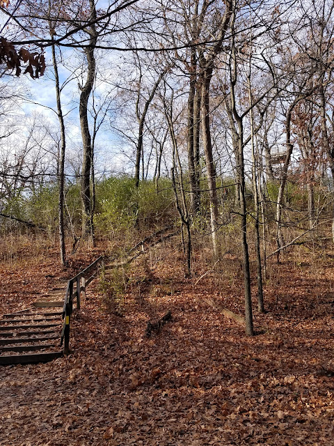
I really enjoyed my hike through Henry and Helen's old acreage. Except that the only way I knew I was on the right path was that I had studied the maps extensively before I started. The signage was abysmal. At one point I stood on an observation platform and was able to visually survey quite a bit of the park. 


What you see laid out there is the Ice Age Trail heading off into the distance, and other crisscrossing paths meant for mountain bikes and other uses. This is why I found the lack of signage so distressing. There are many trails in this park, and after descending the hill with a large switchback, which uses three relatively good blazes but could have used five, I think I only saw three or four more blazes for the next three quarters of a mile around the point. 

The trail does have boardwalks in a number of places, though, and it was on one of those that I crossed paths with Theresa. 


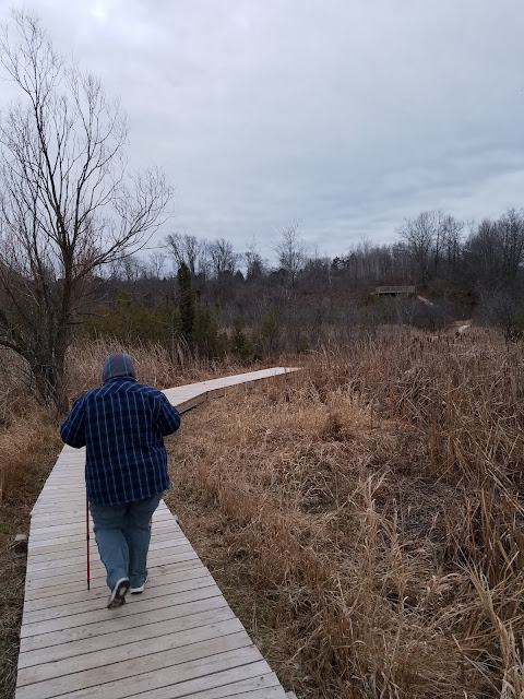
Obviously it gets wet down here at different times of year. For today, everything was frozen solid.     

On I went. The trail is level and easy to walk, except for occasional small bumps.

A rare blaze

And there are more boardwalks when you might need them. 


You even get to walk under the Canadian National Railroad Line. 


If I were a Schuette boy, growing up in Manitowoc, I don't think you could have kept me out of these woods. It was a delightful place to visit. There were flocks of geese on the river ice and many more sailing by overhead as the early setting sun heralded in dropping temperatures and approaching winter. 

The crisp, still air didn't feel all that cold, but gloves were still nice to have. I was all alone on the trail after I passed Theresa, but for two rabbits that jumped out of the way as I passed. 

I reached the end of the hike through the park at 4:34 pm. Darkness was fast approaching, and by the time Theresa got here to pick me up it was full-on black. 


The next leg was a short walk up Clay Pit Road that took us to Revere Drive, past the 'Chiefs Club' which boasted a completely offensive cartoonish Indian as a logo. I won't even dignify that one with a photo. 

Then I had Theresa walk north to cover the 0.6 miles along Revere Drive, while I drove up and parked just around the corner on Michigan Ave. This leg walks past the very large Evergreen Cemetery and across a high bridge over the Manitowoc River. The river itself was almost invisible in the darkness, but if you look down on the west side you can see the remnants of a much older bridge that must have crossed just above the water line. There is even an old street sign that now faces the water, amidst a tangle of brushy undergrowth, forlorn, forgotten and useless. 

More memorable, perhaps, is the eternal flame that burns on the median strip in front of the cemetery with a flag flying at half-mast, in mourning of the most recent in a string of tragedies.


We were doing this in ridiculously small chunks because we didn't want to miss any turns. We were now a mere seven tenths of a mile from the end, and we decided we would chance just one turn. It was a mistake. 

The last leg (west to east) travels along Michigan Street, where it dumps out onto 11th Street, before turning into Water Street and ending at Park Street where we left off a week or two ago. 

Except that it doesn't. 

Unknown to us, because we missed that little detail, Michigan Street turns into Huron Street before it reaches N 11th Street. So when I dropped Theresa off at the Linebacker Bar to make her way east, I told her she was looking for Michigan Street. 

I blame myself for the fact that she missed her turn onto Huron. There is a sign indicating that there is a turn, but it is nowhere near the actual corner, and she didn't see it. In the four plus years since Manitowoc became an "Ice Age Trail Community", they haven't done a very good job of maintaining their urban signage. 

So while I was hiking down Michigan Ave and saw it turn to Huron Street, I realized there was a problem. I could see a long way down the road, and I couldn't see Theresa. 

At 6:30 I called her.

"Where are you?"

She told me, and I cringed. She was four tenths of a mile past the turn, still looking for Michigan Street. She said she figured something was wrong, because she didn't recognize anything. 

I had her turn around, and come back down while I went up to meet her. Together we walked back to Huron Street and I pointed her four tenths of a mile west while I hiked the last quarter mile south to the Linebacker. If she hadn't missed the turn, she would have been done by the time I called her. 

It was not the celebratory end to the day we were hoping for. Instead we dragged ourselves to the finish line at just shy of 7:00. The temperature had fallen to 24 degrees. We were bedraggled, but on the plus side we were successful at walking off of map 95, so we got to add one more orange square in the front of the atlas. 

For the first time I went through and counted how many maps we have left to go, and it's only 40. That means we've completely finished 72 maps, and there are a number of maps where we have completed a large portion. 

We're starting to look down the road and ask 'How many are left?', with regard to maps, miles, counties, and segments. What's amazing to me is that this is becoming a countable number. We have achieved amazing things this year, and even if I can't yet see the light at the end of the tunnel, I can hear the faint rustle of wind far ahead. I know the light is there, as surely as I know the sun shines on the other side of the earth while I sleep in total darkness. 

Running Total: 849.1 miles of trail covered, 142.2 miles 'extra' hiking/biking. End of Day 122.

Sunday, November 21, 2021

Day 121Delafield Segment, Hartland Segment (Part 2), Waukesha County

Day 121: Sunday, November 21st, 2021

Total Miles covered for the day: 6.8

Location 1The Delafield Segment, between the west trailhead and N Lapham Peak Road, except the 0.9 miles through the park
1.0 miles of trail covered

It's a good thing we're flexible. But sometimes hiking with other people can prove chaotic.

When we told people we would be hiking in the Hartland/Delafield/Lapham region this weekend, we were besieged with messages from people who wanted to connect with us, or hike with us, so as to get their SnOTT patches. And a good many of them actually showed up at some point in the weekend.

Today the plan was to hike the Delafield Segment in the morning, then hike the rest of the Hartland Segment in the afternoon, followed by an early start on the long drive home. Our meeting point was the end of the Lapham Peak Segment, at the parking area on North Cushing Park Road, and there we found our first two Snails of the day. If we thought the parking there was bad yesterday, today was ridiculous. The parking area is small, and there was at least a five-vehicle overflow stacking up along the roadway. 

After explaining our hiking method, we arranged to drive to our launch point, the large parking area between Sanctuary Lane and Main Street, just off of N Lapham Peak Road. There, we had our ceremonial awarding of the SnOTT badges, and congratulated Tiffany (Tiff Tiff) Virag, Nancy Lecher, and a pointer named Marshall Trempaleau for earning their patch. 

We actually gave Marshal Trempaleau his own patch. As I understand it, he now wears it on his doggie vest. 


The time was 10:13 am, and it was 41 degrees. It was sunny, but also a bit breezy and the air felt quite cold. Definitely a November kind of day. 

While I was writing down names, and getting the time and temperature recorded, Theresa and our three Snail Hikers took off down the trail at a decidedly un-snail-like pace. It's a paved bike trail through here, and it's easy walking. Even so, I could see how fast the pace was being set, and I was surprised Theresa was able to keep up with them. 


Straight into town we went, along the old railroad bed, long since converted to a bike trail. After crossing Bleeker Street, it turned into urban hiking, more or less along the sidewalk. 

Somewhere in here, I received a text message from CJ Pape, who was interested in crossing paths with us. She had arrived, just two minutes late, at the parking area on N Cushing Park Road, but it was the wrong parking area. There is another one north of where we started, in Cushing Memorial Park, and while she and her husband Terry were waiting for us to connect, they started walking the trail east while we were walking west. 

No problem, I thought. Except that they were sending pictures that didn't make any sense to me at all. In the meantime, while I was lagging behind and trying to communicate with CJ, and figure out where on earth she was, Theresa and the merry trio were trucking along down the sidewalk, finishing their walk on Wells Street and headed down main street. They were getting further and further ahead of me, and when I saw Theresa slowing down, with the other two far in the lead, I hustled to catch up to her. 

To be honest, I was getting flustered because I couldn't seem to figure out where CJ and Terry were, because they were sending me pictures that didn't look anything at all like what we were seeing, and I was convinced they were somehow on the wrong trail, or going the wrong direction or something. 

Just when I caught up with Theresa, we ran into four people walking the sidewalk who were enjoying the IAT. One of them knew instantly what we meant by 'Snails' and was delighted that she had run into us. Theresa handed out patches, and I was left behind to take names and photos. 

Introducing Susie Jodie, Julie Erdtmann, Betsy Sato, and Sharon Thoma. 


Oh - and a Boston Terrier-Pug mix (a 'Bugg', apparently) by the name of Lucy.


You heard that right. For the second time in two days, we ran into a small dog named Lucy. What are the odds?

When I looked up again, Theresa was trying to catch up to Nancy and Tiffany, and I was still trying to figure out why we hadn't seen CJ anywhere. I hoofed it down the sidewalk at a full trot until I caught up with Theresa, just before the corner of Main Street and North Cushing Park Road. 

It was here that the universe realigned, and we figured out what went wrong. 

Almost exactly a half mile earlier, when we crossed Genesee Street, the IAT went north, and we went west. I never put much thought into trail blazing, because I was never in the lead. And while I was fussing with my phone trying to communicate with CJ, I missed the turn, and that was the end of it. 

When we reached that corner, by Kurt's Steakhouse, we saw that the trail went both left and right, and I was at last able to pull out my maps and determine that we had missed nearly a mile of trail that we would have to circle back around to later. It also did a lot to explain what happened to CJ, though we didn't get a final answer on that for a while. 

So Theresa and I turned left and headed for the car. We didn't actually catch up to our two hiking companions (and their dog) until we reached the end. They were just getting in their cars, and we bid them farewell while Theresa and I went all-in trying to figure out the CJ mystery. It was 11:15 am. 

CJ, as it turns out, had hiked the segment many times. She wasn't lost, we were. She new that, and she was very gracious not to mention anything about it. She told us that before the trail went through the Memorial Riverwalk and along the Bark River, it used to go straight down the road where we walked. That was why, we reasoned, our two hiking companions had marched blissfully forward rather than following the blazes. They knew where the trail was. They had been there before. Only it wasn't there anymore, and we weren't quick enough to catch the error before it was too, too late. 

Another thing that dawned on me as we were looking for CJ was that the four people we met earlier who were half-heartedly keeping an eye out for us, actually did find us, but they weren't on the Ice Age Trail either at the time they did. We were all lost. Maybe it was fate. 

Long story short, we finally did hook up with CJ and Terry, and we gave each of them a well-earned SnOTT patch, because they probably worked harder at finding us than anyone else had till now. 


I was just in the process of writing down their names when my phone rang. It was work. Time for another Sunday interruption. 

Originally we were going to hike the rest of the Delafield Segment right away, but between the fact that I was on a call from work and the fact that the person we were meeting for our hike later that afternoon was already sitting there waiting for us, we decided to abandon Delafield and go finish the Hartland Segment. 

Location 2The southern half of the Hartland Segment, between the Cottonwood Wayside and the south trailhead
3.6 miles of trail covered

Theresa drove us to the end of the Hartland Segment, which is hidden somewhere in the parking lot at the intersection of Golf Road and Hwy 83. Actually, it looks like the segment officially ends halfway across the highway. I didn't see a sign. 

While I sat on the phone, Theresa went and talked to Mary Schwab, who was there waiting for us. This was the same Mary we hiked with on Friday Night and Saturday both, and she was being pretty committed considering she was such a beginner. 

We were early for our planned start, but we weren't expecting anyone else to join us, so we decided to get going anyway. I had no idea how long my call would take, or what type of assistance was needed. I told Theresa and Mary to start hiking north, and told them that I would either meet them at the other end, or I would cross paths with them along the way. 

So while they hiked, I drove around looking for internet. I eventually wound up in the parking lot at Culvers, and had gotten hooked up with internet for a period of about 15 minutes when I once again realized that there was nothing else I could do on the computer. So, I transferred the call to my cell phone, put on headsets, and left to hike the Ice Age Trail while I worked. 

It had been a good 45 minutes or more since Mary and Theresa had left, so they had a pretty good jump on me. I parked at the Cottonwood Wayside where we had left off two days earlier and headed south. It was about 1:00 pm, and the sun was shining merrily, though it was still quite nippy.

I crossed the street and headed south along the sidewalk, which ran first along the road, then along a greenspace of sorts between buildings, before crossing CTH KE. 

Then the trail became an actual trail, crossing an open field area before climbing up a big hill into the woods, eventually climbing over 70 feet in elevation. The trail through this woods was quite hilly, and the terrain was a bit slippery, mostly because the leaves were wet. There were a number of rocks to avoid, and the tread was sometimes a bit on the angled side, but all in all it was a reasonable hike. It had been kept clear of obstructions, and I was able to absent--mindedly make my way along while I tried to concentrate on my phone call. 

This building, that I passed on the way, caught my attention enough that I stopped for a photo. I'm glad we didn't encounter this one while out night-hiking. Pretty brick house, but that naked, gnarled oak in the yard gives it a creepy feeling. 


One benefit I got by being in the woods was that I was out of the wind, which was persistent and cold. The trail was really well marked while it went through the woods, and I met Theresa and Mary on the trail shortly before taking the photo of the house.

They told me that in a short distance I would come out on the road, and have the opportunity to hike through the street for a while. When I got there, I took a photo of this sign.  


It seemed like too many right turns in a row, and as I was walking that 1.2 miles among all the very expensive homes, it felt the same way. Every time I got to the correct intersection and had to turn right, it felt like I was going the wrong way. For that matter, it felt like a lot more than 1.2 miles, because I was still on the phone battling a problem at work, and I was out in the very stiff, cold breeze howling in my face as it raced up the hillside. 

They are amazing houses. I just wish there had been one or two along the way who might have agreed to put a yellow blaze on the sides of their mailbox post. I'm not complaining, though. I made it through, and so did Theresa and Mary. 

Finally leaving Fairway Court, the trail turns sharply south and starts skirting the Naga-Waukee Golf Course. When I first turned west in here the trail was at the bottom of a ravine, and I thought about how terrible it would be trying to get through here in the rain. For all I knew it would become an impassible flood zone. 

The trail went south again along the edge of the golf course and along Park Service Road before reaching the highway and the end of the segment. It was when I was walking past the golf course, coincidentally, that we finally got the better of the problem at work, and I was just ending my phone call as I reached the car. 

I tried contacting Theresa, to no avail. She didn't answer the phone, and she didn't answer text messages. I was actually starting to get a tiny bit concerned, because I thought they should have finished long before, when they came driving into the lot with the van. 

No problems - no delays. They just took their time. Gotta love a Snail in full-color. 

Location 3: The Delafield Segment, between the east trailhead and N Lapham Peak Road. 
1.3 miles of trail covered

So we said good-bye to Mary for the third time that weekend, and turned our attention to the rest of the Delafield Segment. We were supposed to have been done with it by now, but so far we had only covered one mile. So we left one car behind and made our way to the parking area on North Lapham Peak Road (where we started the day) and began hiking east. We were definitely starting to feel tired. Theresa's feet had started hurting, and even my knee was giving me problems. It does that occasionally when I walk long distances, especially if I try to hurry across tough terrain. 

Once again, we were on the paved bike path, and we took the time to walk slowly, hand-in-hand. We were going west to east, which was fortunate, because that's the same direction the wind was howling. It was partly cloudy, and it was getting nasty cold. Our whole bodies were starting to feel it, beginning at the fingertips. 

The trail goes just uphill of Milwaukee Street, and we had a terrific view of Lake Nagawicka, with the waves pounding against the shoreline. We were far enough away that it didn't affect us, but we felt colder just looking at it. In the other direction was a scenic little pond. 


I have no idea why my phone took this shot, but I kind of liked it, so I tossed it in here. 


We did pass a couple of people as we walked. One woman was out walking twins in a double-stroller, without gloves. Another was a guy out walking his dog. Pretty typical urban pathway. 

The trail eventually crosses Milwaukee Street and heads up a small hill before passing behind the Naga-Waukee Ice Arena. We could see the parking lot coming, and we were really, really happy to reach the car when we did. It was 3:50, and we had finished the east half of the Delafield segment. Now we need to go back and re-do part of the western half.

When I checked the temperature it was 42 degrees, but I could have sworn an affidavit for ten degrees colder than that. 


Location 4Delafield Segment, covering the 0.9 miles through the park
0.9 miles of trail covered

We didn't really feel like hiking any more. We were supposed to be done by now. It was late, we were cold, we were hungry - but that doggone nine tenths of a mile was all that kept us from finishing the Delafield Segment and map 82 besides. 

We dropped a car off at the Genesee Street crossing, then drove to Kurt's again and wound ourselves up for one more stroll. I'm really glad we did.

The hike along the Bark River was the perfect way to end a long, hard weekend. 


It starts out on a nice boardwalk.


And gives a lovely view of the river.


Where we encountered a large group of cranes. 


Many cranes. 


Many, many cranes. 


Over 25 in all. 


It was the perfect time for us to be walking through here. If we had come earlier in the day, we would have missed them. 

We continued our walk along the river, and finally came to the spot that CJ was trying to tell us she was waiting for us hours earlier, where the trail crosses the river on a foot bridge.  


This is a walk backward in time, commemorating the different wars we have been engaged in. I'm sure this walkway means many things to many people. For me, it was a reminder of how much was lost. I wonder sometimes if everything that was gained was worth the terrible cost. 

The last flag we walked past was the 'Don't Tread On Me' flag of the Revolutionary War, flying side-by side with the original Stars and Bars flag. It was a peaceful walk, but by now even the last three, long city blocks to the car felt like a burden. 

We ended at 4:45 pm, and somehow the temperature had risen one degree to 42. We sat in the car and warmed it up for a while, happy to be out of the wind. Just as we were leaving, we heard sirens, and waited as not one, but several police and ambulance vehicles made their way Code 4 to the highway. After they had passed, we went to Culvers for dinner and started the long, dark drive home. 

We learned the next day that the sirens we heard were related to the terrible holiday parade tragedy in Waukesha, a short distance away. It was a somber reminder that every day is a gift, and I feel lucky that we have the means and the opportunity to spend our days exploring the state five miles at a time. 

Running Total: 843.1 miles of trail covered, 141.9 miles 'extra' hiking/biking. End of Day 121.

Saturday, November 20, 2021

Day 120Lapham Peak Segment, Waterville Segment (Part 1), Merton Segment (Part 2), Waukesha County

Day 120: Saturday, November 20th, 2021

Total Miles covered for the day: 9.3

Location 1The Lapham Peak Segment
7.8 miles of trail covered

November 20, 2021. Opening day of Deer Season in Wisconsin. Day of the Snail. 

When we looked at the list of places we had left to hike that might be 'safe' during deer hunting season, Lapham Peak was the one that stuck out the most. It wasn't in a city (nothing wrong with city hikes, but frankly they can be done anytime) and there was absolutely no hunting allowed anywhere along the way. Perfect.

Today we woke up in our Airbnb and prepared ourselves for a potentially large group hike. We had a number of people who told us they might attend, and we didn't know if we'd be hiking with two other people or ten. The number ended up being somewhere in the middle. 

We've given up on explaining to people in advance how we hike. No one gets it until they go with us once, so we just told people to meet us at the Parking Area along CTH C, in Lapham Peak Park. We stopped by early, about 8:30, and we were scoping out the various places to park. This one was obvious, and we checked out the top of the hill, too, but opted not to use that one. Then we drove over to Hwy 18 and saw the ominous No Parking signs, which definitely gave us pause. Finally, we drove to the south/west trailhead parking area long enough to see that it would work out fine, and headed north to place our target vehicle at the north trailhead. That small parking area, on S Cushing Park Road, was completely jam packed when we got there, so we had to squeeze the car in along the edge of the road. 

And when we got back to the Lapham Peak parking area we couldn't believe our eyes. The parking lot was crammed full, with well over 100 cars there, and more pouring in by the second. We felt lucky to have gotten a parking spot at all. We were right on time at 9:30 am, and we had no trouble at all identifying the hikers who were waiting to meet us and to get their SnOTT patches. 

Mary Schwab was there, the same woman we hiked with the night before, and so were three new snails by the names of Laura Hinesh, Donna Hecht, and Julie Frechette.


Donna Hecht, Julie Frechette, Laura Hinesh

This was indeed a group of well-seasoned hikers, as their hiking gear would tell you. 

With everyone ready, and having given up on a couple of maybe's, we started our hike at 9:45 am, temperature 38 degrees.

From the Park, we took the tiny little spur trail one tenth of a mile south to intersect with the IAT, and then headed west across the road, across the marsh, and into the prairie. 


There was a great boardwalk that got us across the marsh.

Strike a pose


This first leg on the north, which is shaped very loosely like the number '2', goes over some low rolling hills of open prairie, which is undergoing intensive restoration. This included periodic controlled burns, and the grass was clearly charred in many places from recent activity. 

In my mind's eye, I can still picture the exact spot on the trail where the whole weekend nearly came to an end. We had just passed this delightful bench, with leftovers from someone's holiday decorations. 


I was catching up to the group...


And shortly after I took this shot I motored ahead, planning on getting a photo from the front. The ground was a little bit uneven, as you can see, and behind me I heard a crash and a collective gasp. Theresa had gone down - hard. 

I turned around to see her lying face up in the dirt. She was in a lot of pain, and she was still mentally assessing the damage for herself. One single step not quite aligned with the pitted pathway resulted in near-catastrophe. 

After a few tense minutes, Theresa determined she should get up and try walking. Her right knee was a mess, having somehow received a significant blow while falling. At least it wasn't twisted, with some kind of ligament damage. There was swelling, and there would be bruising, but the knee was holding solid, and she decided she could give it a go. 

Never underestimate the ability of a snail to persevere. 

Our pace, already less than typical for our three new hiking companions, slowed down now to a true snail's pace. To their credit, they showed no signs of dismay whatsoever, and gave every indication that they were having a great time no matter how fast or slow we were going. 

The prairie section of Lapham Peak looks a little like a pine tree when you peel the bark off after it's been standing dead for a couple of years. There are trails wiggling through all over the place, just like the trails left behind by beetle larvae as they eat their way through the delicious cambium layers. The IAT travels one of those trails, but we saw people all over the place, and on every which trail. Dozens of them, out walking dogs, jogging, carrying children on shoulders - it was a great day to be out in the sunshine, and everyone here was taking advantage of it before the snow came. 


We passed a bench or two, and I was surprised to see that Theresa chose not to sit and rest her knee. She later told me she was afraid it would get stiff and she felt she would be better off just walking. It turns out she was right, and by the end of the day that stiffness was in full force. 

Two of the people we crossed paths with were some that thought they might join us on the hike, but couldn't get there in time. Instead, they started at the north end and walked south in hopes of crossing paths with us, and we were able to greet them out there in the prairie. 

Welcome, Deanna Schneider and Brad Harkins! Congratulations on earning your SnOTT Patches!


Some of the prairie flowers were still in full seed. 


There is a nice view of a beautifully maintained barn. 


There is one small bit of trail that cuts through the woods and just before heading back into the field we passed by a pile of rocks that had been whimsically piled into little inukshuks. 


We reached the end of the first leg, and said goodbye to Donna and Julie. They turned around to hike back to their car on foot, and the rest of us piled into the van and headed south to Hwy 18. 


The place where the trail crosses Highway 18 is NO LONGER A PARKING AREA. It used to be, and someone had gone through the trouble of mowing a large area there, but there were so many cars parking there that the overflow was going onto private land. This resulted in the DOT putting up a string of no parking signs on both sides of the highway. The Resource Map lists this as a permanent closure and tells people not to park there. 

All of this is information we gathered after the fact. This morning, as we stared at all the no parking signs, we were a little befuddled. There was already a car parked there. There was a large clearing behind the No Parking signs. There were tire tracks everywhere, proving that many, many cars continue to park there. Did it mean that you couldn't park along the highway, but you could park behind the signs? 

We decided to chance it. Deep down inside I knew I was seriously risking a ticket, or even getting towed. In the end I got lucky and there were no problems, but that was just luck. Maybe the local deputies were all out deer hunting. 

The four of us started hiking north again at about 11:15 am. This leg of the segment was a beautiful, sunny stroll through a lowland oak flood plain along Scuppernong Creek. There were plenty of blazes, the footing was level and easy, and there were benches as we went. I don't know how warm it was, but with full sun and essentially no wind it was a glorious day for a hike. 

When we got to Boys School Road we passed Deanna and Brad again, making their way south. We were keeping our eyes open for another pair of hikers as well, but instead we got caught up from behind by a guy who was out doing a shake-down walk in preparation for hiking the Pacific Crest Trail next year. 

His name was Evan Hanna, and he was a very interesting man. He had been many places in the world, including hikes up famous peaks like Kilimanjaro. He didn't know anything about us (The Snails) but when we told him about our trek he was happy to take a patch for his collection. He was even wearing his snail colors. 


Another thing I noticed was his equipment. He had a great backpack, an Osprey Atmos AG 65. This thing was properly fitted for true and serious hiking. What I ended up with was a serious case of pack envy. Who's green now?

Time to keep hiking.


When we got off the level ground and started hiking uphill, we finally ran into Kevin and Sue Hanley, with a Corgi by the name of Lucy. We had been texting back and forth with them, so we knew we would meet up with them eventually. 

I kept trying to get a photo of the three of them together, and Lucy was having none of it. 


I finally ended up with this shot, where Lucy looks like a 200-pound monster. 


In the end I had to go with a photo taken later by the owners, as Lucy was enjoying a snack we gave her. 


Now THERE'S that Corgi smile!

Besides being the proud owner of a classic Corgi, Kevin is also an avid photographer and naturalist, whose photography was quite simply breathtaking. I add one here with full credit to Kevin and the statement that I, quite literally, could never. He puts a lot of his shots on iNaturalist


As we were hiking, I noticed this rock. The size can be estimated by comparing it with the oak leaves in front, and some of the holes went all the way through. 


This was evidence that we were hiking atop the remnants of an old coral bed. 

Now that we were headed west again, we started picking up some changes in elevation. At first, they weren't too bad, but then we took a sharp turn to the west and started walking up the east side of Lapham Peak, straight up a long set of stairs and to the foot of the observation tower. I said that in one sentence, but on the ground it felt like quite an achievement. 


We each took the stairs at our own pace, and there is a bench halfway up for those who need it. Laura and I decided we'd truck up a little faster than the other two, because we both wanted to hike up the observation tower at the top of the hill. 


From the top we took our obligatory photos of the world beneath us. 


And Laura was kind enough to snap a shot of me as well. 


We reached the tower at 12:49, and everyone felt good about taking a little break to eat a snack from our trail food supply. There was also the convenience of a restroom nearby, and we took advantage of that as well. 

We were back in the State Park. The trail was broad and trampled, with not too many rocks. Just as we started down the west side of the hill we ran into two new but serious hikers, Carly and Nadav, and we spoke to them a while and gave them some pointers. 


It was clear from their gear that they were taking the Ice Age Trail seriously. 

"Just keep following those yellow blazes," we told them. That was advice we wish someone had given us on our first day. 

From then on, it was downhill all the way. We made short work of the remaining distance and soon found ourselves at the boardwalk leading back to the car. 


It was 1:45 pm, and it was time to reposition ourselves for the last leg. I noticed Theresa was a little stiff getting into and out of the car. "Don't worry", she told me. "This is nothing. It will get worse."

I was more than a little relieved to get to Hwy 18 and see that the van was still there. Even so, we didn't want to risk leaving it there any longer, so we picked it up and took all three vehicles to the parking area at the west end, near the Waterville Field Station. Then Theresa took me and Laura and dropped us off where the van had been, and she went back to the trailhead to walk with Mary. We were doing a crisscross, and when Laura and I finished, it was my job to go back and pick them up at the Hwy 18 crossing. 

The entire pathway along this stretch is a paved bike route, and Laura and I were making great time, even catching a geocache or two along the way. Even so, we were surprised at how far we had gotten before crossing paths with Theresa and Mary. 

"On the plus side," Theresa said, "we didn't walk right past the car again."

"What happened?"

"We had a little trouble finding the trailhead. We ended up walking down Waterville Road a ways until we spotted the trail, then ended up walking the wrong direction for a bit before turning around and heading this way."

I pulled out my maps. "You got on the road, then got on the trail from there?"

"Yes."

"Well," I said, "the other good news is when we walk the Waterville Segment we have a half-mile less of it to cover."

I teased them ever so slightly, but told them they could look forward to a nice, level walk on a paved trail all the way to the end. I told Theresa I would go ahead and walk the extra half-mile just so we could log it, and I would be there in time to pick her up. 

When Laura and I neared the end, she excitedly pointed out the barn she loves to see every time she gets to this part of the trail. It's not much to see in the first photo, but as we got closer it was much cooler. 


We reached the end of the Segment at 3:06 pm, though Theresa wasn't done hiking yet. The temperature was 46 degrees, and it couldn't have been a better day. 


And directly opposite this sign, the barn was in full sunshine, across a golden grassy field.


This was my last view of Laura Hinesh. She went north on the blue spur trail and I went south, to knock off that half-mile of the Waterville Segment that Theresa and Mary had already hiked. 


Location 2The Waterville Segment, between the east trailhead and - whatever you would use to describe the spot a half-mile down the trail.  
0.5 miles of trail covered


While Theresa and Mary hiked east to finish off the Lapham Peak segment, I hurried through the 0.5 miles of the Waterville Segment she had hiked by mistake. It was flat and straight, with a 90-degree turn in it that gave the impression we were walking the exterior of someone's lot line. There isn't much to tell that isn't showing in the photo above. It was a nice path through a very young stand of trees. I soon came out onto Waterville Road, and walked south just far enough to make sure I covered everything she had done. Then I hiked the road back to the car and our tiny little Waterville adventure was over for the day. 

I drove back up to 18 to pick up Theresa and Mary, and they finished their walk at 3:53 pm. It was still 45 degrees, and I snapped this photo to celebrate having covered the entire Lapham Peak Segment in a single day, all 7.8 miles of it, not to mention a little bit more. 


Location 3The Merton Segment, between the west trailhead and the location where the trail crosses CTH VV 
1.0 miles of trail covered

This - was my idea. And it was a bad one. 

After a successful event today, I asked Theresa if she wanted to try to make more progress on the Merton Segment. What could go wrong, after all? It's just a road hike, or else on a bike path, right? We were geared up for it, and we both had headlamps. 

This is not the first time I have been snookered by a bike path. 

Against Theresa's better judgement, we dropped a vehicle off at the west trailhead, or rather the parking area just a bit west of that spot, and then drove partway down CTH VV to where the trail crosses the road. There's actually a pretty good parking area there, so it seemed like a good spot. This was only a mile from the end, and we were using it as a way of judging how Theresa's knee would respond, given that it had stiffened up considerably over dinner. 

We started out, sensibly enough, at about 6:30 pm. There were no signs right there in the middle, so we just started walking, and things were going pretty well at the start. The way was level and paved, and Theresa could just limp along without stressing her knee too much. It hurt, but on the plus side it helped her forget about the pain in her foot. 

The first road we crossed was CTH E, a mere four tenths of a mile into our walk. Across the road was a sign indicating that the trail continued forward down the bike path, and we kept walking.

And we kept walking. How far does this thing go? Have you seen a trail sign lately?

By the time we reached buildings, I knew there was something wrong. I stopped and pulled out the maps. We had blown by a turnoff we didn't know existed and passed it by three tenths of a mile. Had we gone the right way, we would have been done already. 

The Atlas maps aren't much help here. The detail is too fine to really see what's going on. The right way to go is to take the bike path a quarter mile west of CTH E, then take a hairpin turn to the right to climb up a steep embankment. From there, the trail goes two tenths of a mile through the woods to end up over on E Kilbourne Road, which is what we did. 


The missed turn was a real party-killer. Even though we only added six tenths of a mile to our trip, discovering that we had to hike up one steep hill and down another put an end to all joy tonight. The woods were pretty, I'm sure, but all we saw was a few big trees as we walked. 

At E Kilbourne Road there is a trail sign, and we did stop to take a picture there. 


Then we turned left and finished the road walk, which took us almost immediately under a tunnel bridge that had been beautifully decorated by enthusiastic paint artists. Spray paint, mostly. With no theme. Some might call it graffiti. 


The Segment ends on the far side of the tunnel bridge and the Monches Segment has a sign there, but we took the blue spur trail back to the parking area, a distance of about a tenth of a mile. 

There was no appetite whatsoever for us to do any more. It was 7:30 at night, and we had used up the last of our enthusiasm. Tomorrow would be another long day of hiking, and today was good and done. We only reached 9.3 trail miles today, but had to hike 10.6 miles to get there. In my estimation, that's another 10-mile day for the record books, and this marked the second time we had achieved this in 2021. 

And Theresa did it on a bum knee.

Running Total: 836.3 miles of trail covered, 141.4 miles 'extra' hiking/biking. End of Day 120.