Day 121: Delafield Segment, Hartland Segment (Part 2), Waukesha County
Day 121: Sunday, November 21st, 2021
Total Miles covered for the day: 6.8
Location 1: The Delafield Segment, between the west trailhead and N Lapham Peak Road, except the 0.9 miles through the park
1.0 miles of trail covered
It's a good thing we're flexible. But sometimes hiking with other people can prove chaotic.
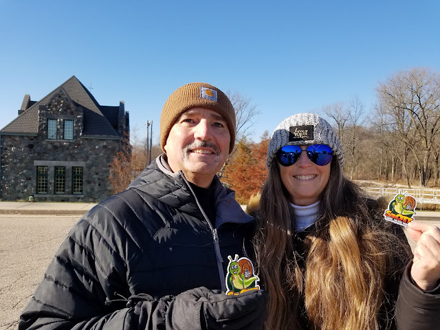
When we told people we would be hiking in the Hartland/Delafield/Lapham region this weekend, we were besieged with messages from people who wanted to connect with us, or hike with us, so as to get their SnOTT patches. And a good many of them actually showed up at some point in the weekend.
Today the plan was to hike the Delafield Segment in the morning, then hike the rest of the Hartland Segment in the afternoon, followed by an early start on the long drive home. Our meeting point was the end of the Lapham Peak Segment, at the parking area on North Cushing Park Road, and there we found our first two Snails of the day. If we thought the parking there was bad yesterday, today was ridiculous. The parking area is small, and there was at least a five-vehicle overflow stacking up along the roadway.
After explaining our hiking method, we arranged to drive to our launch point, the large parking area between Sanctuary Lane and Main Street, just off of N Lapham Peak Road. There, we had our ceremonial awarding of the SnOTT badges, and congratulated Tiffany (Tiff Tiff) Virag, Nancy Lecher, and a pointer named Marshall Trempaleau for earning their patch.
We actually gave Marshal Trempaleau his own patch. As I understand it, he now wears it on his doggie vest.


The time was 10:13 am, and it was 41 degrees. It was sunny, but also a bit breezy and the air felt quite cold. Definitely a November kind of day.
While I was writing down names, and getting the time and temperature recorded, Theresa and our three Snail Hikers took off down the trail at a decidedly un-snail-like pace. It's a paved bike trail through here, and it's easy walking. Even so, I could see how fast the pace was being set, and I was surprised Theresa was able to keep up with them.

Somewhere in here, I received a text message from CJ Pape, who was interested in crossing paths with us. She had arrived, just two minutes late, at the parking area on N Cushing Park Road, but it was the wrong parking area. There is another one north of where we started, in Cushing Memorial Park, and while she and her husband Terry were waiting for us to connect, they started walking the trail east while we were walking west.
No problem, I thought. Except that they were sending pictures that didn't make any sense to me at all. In the meantime, while I was lagging behind and trying to communicate with CJ, and figure out where on earth she was, Theresa and the merry trio were trucking along down the sidewalk, finishing their walk on Wells Street and headed down main street. They were getting further and further ahead of me, and when I saw Theresa slowing down, with the other two far in the lead, I hustled to catch up to her.
To be honest, I was getting flustered because I couldn't seem to figure out where CJ and Terry were, because they were sending me pictures that didn't look anything at all like what we were seeing, and I was convinced they were somehow on the wrong trail, or going the wrong direction or something.
Just when I caught up with Theresa, we ran into four people walking the sidewalk who were enjoying the IAT. One of them knew instantly what we meant by 'Snails' and was delighted that she had run into us. Theresa handed out patches, and I was left behind to take names and photos.
Introducing Susie Jodie, Julie Erdtmann, Betsy Sato, and Sharon Thoma.


When I looked up again, Theresa was trying to catch up to Nancy and Tiffany, and I was still trying to figure out why we hadn't seen CJ anywhere. I hoofed it down the sidewalk at a full trot until I caught up with Theresa, just before the corner of Main Street and North Cushing Park Road.
It was here that the universe realigned, and we figured out what went wrong.
Almost exactly a half mile earlier, when we crossed Genesee Street, the IAT went north, and we went west. I never put much thought into trail blazing, because I was never in the lead. And while I was fussing with my phone trying to communicate with CJ, I missed the turn, and that was the end of it.
When we reached that corner, by Kurt's Steakhouse, we saw that the trail went both left and right, and I was at last able to pull out my maps and determine that we had missed nearly a mile of trail that we would have to circle back around to later. It also did a lot to explain what happened to CJ, though we didn't get a final answer on that for a while.
So Theresa and I turned left and headed for the car. We didn't actually catch up to our two hiking companions (and their dog) until we reached the end. They were just getting in their cars, and we bid them farewell while Theresa and I went all-in trying to figure out the CJ mystery. It was 11:15 am.
CJ, as it turns out, had hiked the segment many times. She wasn't lost, we were. She new that, and she was very gracious not to mention anything about it. She told us that before the trail went through the Memorial Riverwalk and along the Bark River, it used to go straight down the road where we walked. That was why, we reasoned, our two hiking companions had marched blissfully forward rather than following the blazes. They knew where the trail was. They had been there before. Only it wasn't there anymore, and we weren't quick enough to catch the error before it was too, too late.
Another thing that dawned on me as we were looking for CJ was that the four people we met earlier who were half-heartedly keeping an eye out for us, actually did find us, but they weren't on the Ice Age Trail either at the time they did. We were all lost. Maybe it was fate.
Long story short, we finally did hook up with CJ and Terry, and we gave each of them a well-earned SnOTT patch, because they probably worked harder at finding us than anyone else had till now.
I was just in the process of writing down their names when my phone rang. It was work. Time for another Sunday interruption.
Originally we were going to hike the rest of the Delafield Segment right away, but between the fact that I was on a call from work and the fact that the person we were meeting for our hike later that afternoon was already sitting there waiting for us, we decided to abandon Delafield and go finish the Hartland Segment.
Location 2: The southern half of the Hartland Segment, between the Cottonwood Wayside and the south trailhead
3.6 miles of trail covered
Theresa drove us to the end of the Hartland Segment, which is hidden somewhere in the parking lot at the intersection of Golf Road and Hwy 83. Actually, it looks like the segment officially ends halfway across the highway. I didn't see a sign.
While I sat on the phone, Theresa went and talked to Mary Schwab, who was there waiting for us. This was the same Mary we hiked with on Friday Night and Saturday both, and she was being pretty committed considering she was such a beginner.
We were early for our planned start, but we weren't expecting anyone else to join us, so we decided to get going anyway. I had no idea how long my call would take, or what type of assistance was needed. I told Theresa and Mary to start hiking north, and told them that I would either meet them at the other end, or I would cross paths with them along the way.
So while they hiked, I drove around looking for internet. I eventually wound up in the parking lot at Culvers, and had gotten hooked up with internet for a period of about 15 minutes when I once again realized that there was nothing else I could do on the computer. So, I transferred the call to my cell phone, put on headsets, and left to hike the Ice Age Trail while I worked.
It had been a good 45 minutes or more since Mary and Theresa had left, so they had a pretty good jump on me. I parked at the Cottonwood Wayside where we had left off two days earlier and headed south. It was about 1:00 pm, and the sun was shining merrily, though it was still quite nippy.
I crossed the street and headed south along the sidewalk, which ran first along the road, then along a greenspace of sorts between buildings, before crossing CTH KE.
Then the trail became an actual trail, crossing an open field area before climbing up a big hill into the woods, eventually climbing over 70 feet in elevation. The trail through this woods was quite hilly, and the terrain was a bit slippery, mostly because the leaves were wet. There were a number of rocks to avoid, and the tread was sometimes a bit on the angled side, but all in all it was a reasonable hike. It had been kept clear of obstructions, and I was able to absent--mindedly make my way along while I tried to concentrate on my phone call.
This building, that I passed on the way, caught my attention enough that I stopped for a photo. I'm glad we didn't encounter this one while out night-hiking. Pretty brick house, but that naked, gnarled oak in the yard gives it a creepy feeling.

One benefit I got by being in the woods was that I was out of the wind, which was persistent and cold. The trail was really well marked while it went through the woods, and I met Theresa and Mary on the trail shortly before taking the photo of the house.
They told me that in a short distance I would come out on the road, and have the opportunity to hike through the street for a while. When I got there, I took a photo of this sign.

It seemed like too many right turns in a row, and as I was walking that 1.2 miles among all the very expensive homes, it felt the same way. Every time I got to the correct intersection and had to turn right, it felt like I was going the wrong way. For that matter, it felt like a lot more than 1.2 miles, because I was still on the phone battling a problem at work, and I was out in the very stiff, cold breeze howling in my face as it raced up the hillside.
They are amazing houses. I just wish there had been one or two along the way who might have agreed to put a yellow blaze on the sides of their mailbox post. I'm not complaining, though. I made it through, and so did Theresa and Mary.
Finally leaving Fairway Court, the trail turns sharply south and starts skirting the Naga-Waukee Golf Course. When I first turned west in here the trail was at the bottom of a ravine, and I thought about how terrible it would be trying to get through here in the rain. For all I knew it would become an impassible flood zone.
The trail went south again along the edge of the golf course and along Park Service Road before reaching the highway and the end of the segment. It was when I was walking past the golf course, coincidentally, that we finally got the better of the problem at work, and I was just ending my phone call as I reached the car.
I tried contacting Theresa, to no avail. She didn't answer the phone, and she didn't answer text messages. I was actually starting to get a tiny bit concerned, because I thought they should have finished long before, when they came driving into the lot with the van.
No problems - no delays. They just took their time. Gotta love a Snail in full-color.
Location 3: The Delafield Segment, between the east trailhead and N Lapham Peak Road.
1.3 miles of trail covered
So we said good-bye to Mary for the third time that weekend, and turned our attention to the rest of the Delafield Segment. We were supposed to have been done with it by now, but so far we had only covered one mile. So we left one car behind and made our way to the parking area on North Lapham Peak Road (where we started the day) and began hiking east. We were definitely starting to feel tired. Theresa's feet had started hurting, and even my knee was giving me problems. It does that occasionally when I walk long distances, especially if I try to hurry across tough terrain.
Once again, we were on the paved bike path, and we took the time to walk slowly, hand-in-hand. We were going west to east, which was fortunate, because that's the same direction the wind was howling. It was partly cloudy, and it was getting nasty cold. Our whole bodies were starting to feel it, beginning at the fingertips.
The trail goes just uphill of Milwaukee Street, and we had a terrific view of Lake Nagawicka, with the waves pounding against the shoreline. We were far enough away that it didn't affect us, but we felt colder just looking at it. In the other direction was a scenic little pond.


We did pass a couple of people as we walked. One woman was out walking twins in a double-stroller, without gloves. Another was a guy out walking his dog. Pretty typical urban pathway.
The trail eventually crosses Milwaukee Street and heads up a small hill before passing behind the Naga-Waukee Ice Arena. We could see the parking lot coming, and we were really, really happy to reach the car when we did. It was 3:50, and we had finished the east half of the Delafield segment. Now we need to go back and re-do part of the western half.
When I checked the temperature it was 42 degrees, but I could have sworn an affidavit for ten degrees colder than that.

Location 4: Delafield Segment, covering the 0.9 miles through the park
0.9 miles of trail covered
We didn't really feel like hiking any more. We were supposed to be done by now. It was late, we were cold, we were hungry - but that doggone nine tenths of a mile was all that kept us from finishing the Delafield Segment and map 82 besides.
We dropped a car off at the Genesee Street crossing, then drove to Kurt's again and wound ourselves up for one more stroll. I'm really glad we did.
The hike along the Bark River was the perfect way to end a long, hard weekend.


We continued our walk along the river, and finally came to the spot that CJ was trying to tell us she was waiting for us hours earlier, where the trail crosses the river on a foot bridge.

This is a walk backward in time, commemorating the different wars we have been engaged in. I'm sure this walkway means many things to many people. For me, it was a reminder of how much was lost. I wonder sometimes if everything that was gained was worth the terrible cost.
The last flag we walked past was the 'Don't Tread On Me' flag of the Revolutionary War, flying side-by side with the original Stars and Bars flag. It was a peaceful walk, but by now even the last three, long city blocks to the car felt like a burden.
We ended at 4:45 pm, and somehow the temperature had risen one degree to 42. We sat in the car and warmed it up for a while, happy to be out of the wind. Just as we were leaving, we heard sirens, and waited as not one, but several police and ambulance vehicles made their way Code 4 to the highway. After they had passed, we went to Culvers for dinner and started the long, dark drive home.
We learned the next day that the sirens we heard were related to the terrible holiday parade tragedy in Waukesha, a short distance away. It was a somber reminder that every day is a gift, and I feel lucky that we have the means and the opportunity to spend our days exploring the state five miles at a time.
Running Total: 843.1 miles of trail covered, 141.9 miles 'extra' hiking/biking. End of Day 121.
No comments:
Post a Comment