Day 116: Devil's Lake Segment (Part 2), Sauk County, Connecting Route, Sauk/Columbia Counties
Day 116: Sunday, November 7th, 2021
Total Miles covered for the day: 3.9
Location 1: The East Bluff portion of the Devil's Lake Segment, between the two parking areas on South Lake Road
3.4 miles of trail covered
When I woke up this morning, I thought I heard voices. Only for a moment, then all was quiet. It was still dark, so I wasn't really sure I heard anything at all, and I went back to sleep for a bit. We were van camping in what I will call a 'secret' spot not too far from Devil's Lake in a designated parking lot for a public hunting area. An actual parking lot, not just some graded piece of dirt along the road. Some day I may come back and reveal the actual location, but for now I'm keeping it secret because I intend to come back and use it again.
Parking anywhere in Devil's Lake State Park and van-camping is a little risky. They frown on that, though I'm told that if you call the park and let them know you're hiking the Ice Age Trail and leaving a vehicle overnight that is OK with them. I'm just not sure how they would feel about finding two sleeping persons inside said parked car. We decided not to risk it.
Unfortunately, it is the nature of 'Public' Hunting Areas that one may end up sharing it with the 'Public', and when we finally got back up again with a little bit of daylight creeping into the van I walked around the corner far enough to find that indeed, another vehicle had arrived in the pre-dawn darkness, parked, and gone out into the woods. Presumably, they were bow hunting for deer, though I was never able to confirm that. Nevertheless, this told me that our quiet, secluded little corner of the world was known to other people. Bummer.
Since yesterday was a long driving day followed by a hike, then another long drive to Dane County to hike a tiny little piece of roadway, then another long drive back to Devil's Lake, we didn't get a very early start.
It was wonderfully lazy.
And why not? Our original plan for the weekend had been to continue our progress from yesterday by trekking along the northern leg of the Devil's Lake Segment, and getting as far as the West Bluff, but instead we decided to skip that and go for the much harder East Bluff South Face leg. Theresa was feeling unaccountably good after yesterday's hiking, so she felt like her feet could take it.
We made the decision to hike east to west. In hindsight it would have been much better going the other way, but I'll get to that later.
We first drove to the large parking area near the bluff and the beach, with the concession stand (which was closed) providing us the outdoor electricity we needed to make our coffee and hot breakfast. We were surprised at how many people were walking through with their dogs, since it was a chilly, windy day, or at least it was at 9:00 am. The bathrooms were closed for the season, and I didn't think anything of it at the time. The parking lot was mostly empty, and we were looking forward to a lovely hike along the bluff in the November sunshine.
Then we drove down South Lake Road and parked at the designated parking area a couple hundred feet east of where the trail crosses the road. by 10:00 am it had gotten up to 51 degrees, and we were packed up and ready to go.


The photo got a lot of comments online, and discussion about exactly what kind of chair it was. Several people thought they were snowshoes, and I totally get that.
The East Bluff Segment is a beast. Similar to the Sauk Point Segment that boasts 660 feet in elevation change from top to bottom, the East Bluff rises from 880 feet in elevation at the road to 1440 feet at the top, making for an impressive 560 feet climb. Even though the elevation change isn't as much, the East Bluff stands out to most hikers as the most challenging part of the Devil's lake Segment because of the steep climb on the west end.
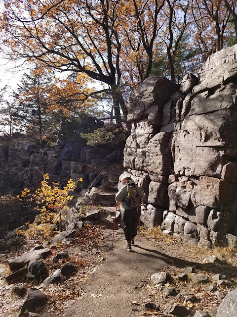
We, however, chose to climb the far more gentle eastern access, which climbs doggedly uphill for about six tenths of a mile before easing up on the climb for the next half mile. But it is very much a climb, and it could certainly have used a bench or two along the way. I'm pleased to say that we made that hike with only one stop.
That hill had beautiful footing. It travels up the bottom of a creek valley, and the trail crosses the creek once as it climbs. There is some great stonework along the way, with a couple of stone steps in places where the way is a little steeper.

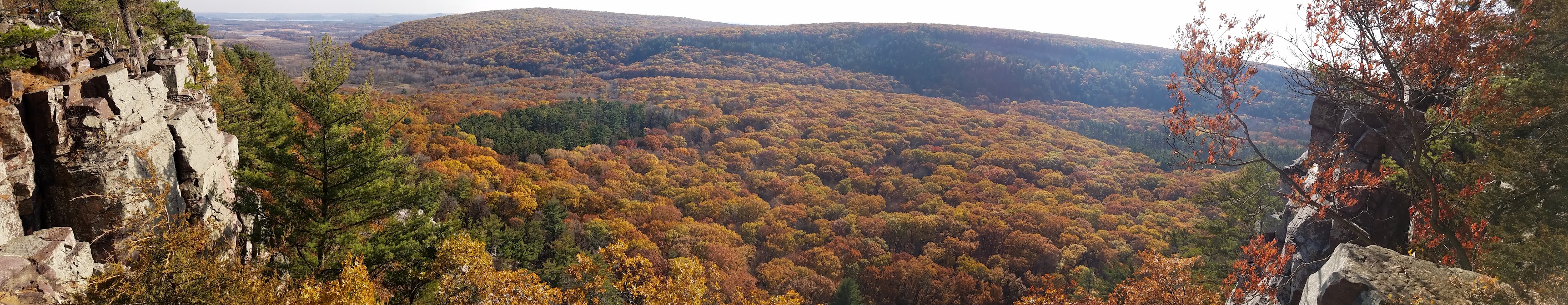
Here in November, 'Fall' is good and gone, but that doesn't mean all the color was gone from the trees. Our favorite group of trees, the oaks, tend to hold their leaves much longer than their arboreal cousins. Their pallete of colors leans strongly to various ocher hues, and the hills were covered in oaks showing their yellow, golden, red, orange and brown finery. There wasn't much understory to speak of. Much of what was there was Japanese Barberry, buckthorn, blackberry and ferns. This made it possible to see long distances through the woods, and we were enjoying the view as we went along.

There are a number of Geocaches on this piece of the trail, and I picked them up as I went along. The one at the top of the hill, though, mentioned something about a "big rock".
I gotta admit. After 800 miles on this trail, I feel like I have seen a lotta "big rocks". The IATA takes great joy and pleasure in taking us significant distances out of the way in order to view one or two big rocks that happen to lay around in the open. Big rocks are kind of a thing for us IAT hikers. And yet, as I viewed this particular "big rock", even I was impressed. It's tough to judge scale from the photo below, but trust me when I say that this outlier is an impressive specimen.

I think it's possible that this isn't flagged as a glacial feature because it looks to be part of the native rock in the area, and not some massive boulder that had traveled with the glacier. I don't care. It's still a big rock, and I thought it was pretty cool.
After reaching what seemed like the top of the hill a couple of times, but finally actually making it to the top, we intersected with the Uplands Trail. This is the trail that cuts across the top of the hill directly from the end of the Sauk Point Segment, and it is a broad gravel pathway that was suitable for strollers or even properly outfitted wheelchairs, or at least it was at this point.
It was here that we encountered Staci Walsh for the second time. We met Staci yesterday while she was waiting for her husband Dale to come pick her up at Parfrey's Glen. We had stopped to make sure she didn't need a ride, and she assured us she was fine. We didn't realize she had reached out to us on Facebook three weeks earlier asking if we would be hiking anywhere near Wisconsin Dells. And here we were chatting with her, but we didn't recognize each other.
Then today, as both she and Dale were hiking the East Bluff, we saw her again and it was only after chatting with her a bit that we finally made the connection that she was looking for The Snails to get her patch. We were delighted to give one to both of them, but sadly I lost the photo I took of them out there on the trail. They were nice enough to send us this photo later.

Despite encountering literally hundreds of people throughout the day, Staci and Dale ended up being our only new SnOTT members.
Once we reached the the top of the bluff, there were plenty of benches to go around. There's nothing wrong with having them all over the place, but we certainly could have used one a mile earlier on the way up the hill.
And we kept seeing more, and more, and more people. There were far too many to count, but I estimate that we encountered between 350-400 people, and no less than 30 dogs. The trail started darting out towards the edge of the bluff, and there were several places to get way too close to the cliff if you wanted to.

The trail continued to be fairly easy to walk, in part because it had been beaten into submission, but also because a lot of the rocks had either been removed or paved over. Yes, there was sections up there with black-top pavement. There is one significant dip in elevation between the two high points, and as I recall there is a bench halfway up the western half of the incline.
 |
| Backpacks and Benches are not very compatible |
I have two panoramic shots here of basically the same view, but each is impressive for different reasons. You'll have to scroll to the right to see it all.


This, perhaps, was our first clue that the next four tenths of a mile, which is the distance used to descend the 420 foot cliff face, would be made up largely of stone steps.
And these are not just your average stone steps. These are steps that are laid or cemented in place across a gigantic scree field made up of talus stones broken off the face of the cliff and strewn haphazardly across the landscape like a pile of thousand-pound stone Legos.
They were, in fact, so steep that Theresa was unable to descend in any normal fashion for most of the way. One careful step at a time, sometimes sideways and sometimes backwards, Theresa crawled down the 'stairs'. Individual drops from one rock to the next were uneven, and could be anywhere from the rare 4 inch drop to the equally rare 20 inch drop, but averaging about a foot or more in height. Too steep for bad knees.
Kids, as you read this, put this kernel of truth away for your later years. If you're going down really steep stairs, it's a lot safer to go down backwards, especially if there is no handrail.
Near the top, there was one young man who was so concerned watching how Theresa was climbing down that he encouraged her strongly to go back the other way. "Isn't there some other way you could get down?" he asked. "There are a LOT of steps, and it's a long way down."
We assured him that yes, we're old and we're slow, but we're also careful and stronger than we look. If we've learned one thing from our snail animal spirit guides, it's that almost anything is possible if you do it slowly and methodically.
Partway down is another famous rock formation known as Balanced Rock. This one is interesting because it appears to be a talus rock, meaning a rock that has fallen off the cliff, rather than one that simply remains after everything around it has fallen away.

The rock is a good ten feet or more in height, and stays balanced there on its nose, where it has sat for who knows how many thousands of years.
In a word, the trip down the hill was hellacious. This is the part of the trail where we really figured out that we did this wrong. Sure, climbing up this stone staircase would have been challenging, but it's a lot less physically taxing to go up a steep climb like this than to go down.
"OK, big drop this time... a little to the left... small step, cheat your leg over to the right a little.. turning here... not much of a place to put your foot here so be careful... big wide step here... "
On and on this went, as I guided Theresa down the hill backwards. Occasionally there were a few places where she could turn around and take a few normal steps down. A couple of times we pulled off to the side to take a break. No need for benches on this part of the trail - every other rock was a decent bench. More often, though, it was other people who were pulling off to the side to let us make our way through. It was really impossibly busy there considering it was NOVEMBER. I can't imaging how many thousands of people would be out here in the heart of summer.
This was the other reason we should have hiked the other direction. If we had hiked up here at 9:30 this morning we would have had the hill all to ourselves. This time of day, getting close to sunset, we were just two more bodies in the way.
The trail does level out a bit, and it is in this spot that the photo was taken that is the feature photo on the cover of the Ice Age Trail Guidebook, 2020-2022 Edition.

When we reached the bottom, and took that last step down to the hard-packed earth where there were no more steps, Theresa let out a banshee yell, loudly proclaiming her victory.
"YESSSS!!!!! I'M DOWN!!!!!!!!!!"
From the people who were immediately behind us, and quite a few beyond our line of sight, a light round of cheers and applause spontaneously broke out. "Woo Hoooo!!" "Way to go!" "Nice job!" "Yaayyyy!!!"
I don't know if that nice young man at the top of the bluff heard us, but the people halfway up certainly could, and I'll bet a lot of them were just happy to hear that the 'old lady' made it down safely.
Even after getting to the bottom, there is still a short walk to the parking lot, and we were both in need of a restroom. With all those people on the trail, there was no way even I could just pull off to the side and relieve myself, let alone Theresa. It was then that we discovered that literally every single bathroom in the park was locked up and 'Closed for the Season'.
Are you kidding me?!? There were hundreds and hundreds of people here. Literally hundreds of cars. Kids. Elderly. People of all shape, size and flavor. How could they close every bathroom? That was insane, and I have no idea what everyone was doing for a bathroom.
We ended our hike at about 5:15 pm, and the temperature was 62 degrees. It was a wonderful place to go, and Theresa and I were thrilled we got to see it. Neither one of us is ever likely to go back up there again.
Location 2: The Ferry
0.5 miles of trail coveredOf all the many unique and wonderful places one gets to travel on the Ice Age Trail, there is none more unique than the Merrimac Ferry. Its official name is the Colsac III, so named because it is the third such boat to shuttle people across the waters of Lake Wisconsin between Columbia and Sauk (Sac) Counties.
The Ferry has a long and proud history reaching all the way back to 1844 when Chester Mattson got a charter and started hauling horses and wagons across the river for a steep fee ($0.35 or $1.00, depending on whom you believe). The State of Wisconsin took over the ferry service in 1933 and eliminated the fee, but kept the wooden boat in operation until 1963, when it was replaced with the Colsac II, a 12-car steel boat that would eventually be replaced with the current Colsac III in 2003 boasting a 15-vehicle capacity.
The Merrimac Ferry, as literally any person actually living in the state of Wisconsin would call it, operates 24-hours a day as long as there is no ice on the lake, and typically runs from April until some time in December. It is Wisconsin's only free ferry, and a crossing can be achieved in only seven minutes once you're actually on the boat.
Today, as we arrived, we were just in time to watch the boat leaving the dock, but we needed to wait only 15 minutes for it to return, and we were first in line. In the heart of tourist season, though, the wait time can be as long as 50 minutes, dealing with a demand in excess of 1200 vehicles a day. In 2020, the ferry stayed open until December 24th, and they made a total of 35,213 trips carrying 206,775 vehicles across the river. (They take pedestrians and bicycles, too.)
It is also the only part of the Ice Age Trail you can hike in your car.
I'm not sure why I didn't take any pictures while we were waiting, or while we were crossing. It was just coming on sunset, and Theresa and I got out of our cars and enjoyed the view as we took the trip for the umpteenth time. Each of us has made many trips across the ferry as we grew up, always enjoying an Ice Cream Cone at the shop on one side or the other as we waited.
No ice cream today, but plenty of nostalgia as we held hands and watched the water sparkle just past the railing.
In a few minutes, the trip was over, and we officially checked off the easiest 0.5 miles of the entire trail. We 'hiked' off the southern edge of map 60 and we're looking forward to to circling back and covering the rest of it.
Running Total: 806.4 miles of trail covered, 139.3 miles 'extra' hiking/biking. End of Day 116.
No comments:
Post a Comment