Day 128: Connecting Route (x2), Columbia County
Day 128: Monday, January 17th, 2022
Total Miles covered for the day: 4.6
Location 1: The connecting route between the Gibraltar Rock Segment on the north and the Fern Glen Segment on the south
2.2 miles of trail covered
Today was Monday, but it was a holiday Monday from work, so we got the bonus day added to our hiking window.
We woke up a lot earlier this morning at the Airbnb because we didn't stay up last night until 2 am putting a jigsaw puzzle together. We always bring a percolator coffee pot with us hiking, because it's an easy way to make hot water for dehydrated foods, or coffee for the morning. This morning we had both, using the hot water to make hot cereal out of Theresa's special homemade granola with some powdered milk.
After that, we broke 'camp' and headed back up to Columbia county to march off a few miles of roadway. The goal was to get from the end of the Gibraltar Rock Segment all the way down to the City of Lodi Segment. This was only 4.6 miles of roadway, so it was very doable.
The first leg was the Connecting Route from Fern Glen to Gibraltar Rock. We left the target vehicle at the Gibraltar end, and once again had a tough time making it up the ice-covered driveway to the parking area. Then we drove down to the start of the Fern Glen Segment, where there was another large, easy parking area to use that had been plowed.
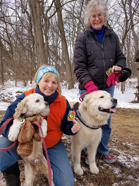
We hiked the Fern Glen segment back in September last year, and it was a charming little segment, even though there was quite a bit of poison ivy around. Before we started hiking, two dog walkers arrived, and we had a long chat with them Naturally, we made Deb Woodworth and Linda Jacobson new honorary Snails.
It was 11:32 am, and it was the kind of a day that you could tell really wanted to become bright and sunny, but wasn't quite there yet. The temperature was 25 degrees, but you can tell from the pictures that there was some cold wind to deal with. Even so, we were eager to get started.

The Connecting Route here runs along County Road J, It's a surprisingly busy road, even on a Monday late morning. There was a bunch of activity going on with earth moving equipment, and people working on telephone poles, but we never figured out what they were up to.

Coming from this direction, it was interesting to be able to see Gibraltar Rock from a distance, and slowly hike up to it. This was the view I had been hoping for yesterday but never got. From over a mile away the rock face was impressive.
We actually spent quite a while standing and staring at the cliff. As we stood there, we could see someone else at the top of the cliff, looking down. We wondered if they could see us, too.
I'm sad to say I lost quite a few photos from that day. I don't know what my phone does to all the pictures I take. I know my memory of that view of the bluff will fade with time, too, so the best I can do is say that I found it incredible that we had hiked up there just the day before, and that I know I may never go again. It was worth the journey.
As we were leaving J and turning onto V, we saw a merlin hanging around in a farm yard. I think. It's a common bird to see in Wisconsin, but you have to know what you're looking for, because they seldom sit vey long and let you see them up close. They are a small hawk-shaped bird, and they have a blue-gray coat with a striped tail and a striped white underbelly. Usually when I see them I identify them mostly by what they are not. Too small for a red-tail hawk, too large for a kestrel, and shaped like a raptor. Conclusion: Merlin. To be honest, it could have been a sharp-shinned hawk. I didn't get that good a look at it.
From there, it was just a hop, skip and a jump to the waiting van, hanging around in that icy parking lot. I managed to walk up the hill and get out of the driveway without falling down or sliding into the street. The night before, Theresa wasn't that lucky. She didn't fall, but when she went down that hill in the car, she slid headlong right out onto the road. Good thing there wasn't another car coming.
We ended this leg at 12:52 pm, and the sun had broken free from the clouds. It was turning into a glorious day for hiking.

Location 2: The connecting route between the Fern Glen segment on the north and the City of Lodi Segment on the south
2.4 miles of trail covered
Because we had already hiked the Fern Glen Segment, we picked up on the other side at the end of Bilkey Road. We actually did this as a crisscross hike, because we were concerned there wouldn't be any reasonable parking near Fern Glen. There certainly wasn't much parking in the fall, and with al the snow we felt certain we would have a problem.
But we were surprised when we got there. Not only was there enough room for one vehicle, it would have been possible to park two cars there. Unfortunately, we had already dropped one car off down the road a piece, and we didn't know there was available parking until Theresa was dropping me off for my part of the walk.

As I started the hike, I was initially concerned about the wind and the cold. You can see from my picture I was well-layered. But as I started walking down Bilkey Road, alongside the enormous cottonwood trees, and in the company of a red-tailed hawk, I could tell that the sunshine and diminished wind had combined to make it a much more comfortable walk.
First, the mask came off. Then the neck gator. Then the coat got unzipped, and the next layer opened up a bit. Eventually, I would end up taking off the gloves, because my hands were sweating. I had definitely overdressed.
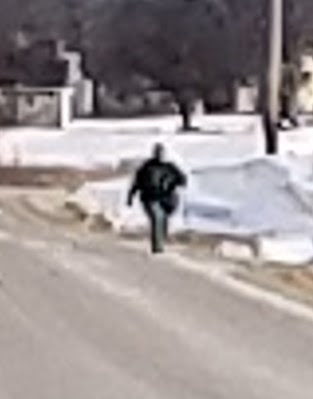
Around the corner, I spotted Theresa off in the distance along County Road J. She's that tiny, little black spot on the right side of the road.

Really! It's her! I swear it is! Same photo as above, zoomed in a little bit.
By the time we crossed paths, she had taken her outer jacket off.
I got to the car and then drove back to pick her up at the Fern Glen end where she had dropped me off about 40 minutes earlier.
 |
| Hey, good lookin'! Going my way? |
We had only about a mile left to go, from the City of Lodi Segment to the car at the north end of Development Drive.
We snapped this pic at the end, which was where the Connecting Route intersects with the City of Lodi Segment.

We took this photo at 2:36 pm, and it was the last one I took today. We actually walked from here to the van and finished up about a half hour later. It's amazing what flat roads and a little cold weather can do for your hiking speed.
This marked a minor achievement for us, having completed map 62. This also meant we had finished all of Columbia County, so that was another one we could check off the to-do list.
We definitely could have done more, but we decided to call it a day. We wanted to get back home as close to dark as we could manage. So - we picked up soup at Culvers and ate our sandwiches, driving home and getting there by a little past 6 o'clock.
I wish I could say the story ended there. Unfortunately, when I unpacked the cars and dumped all the gear into the living room, I couldn't find my computer. My work computer. The computer I needed to use the next morning at 7:00 am.
I called the Airbnb, the only place where it could have been, and got no answer. I got a text back from the hosts a little later, saying that they were not home, but would be getting home a little past eight, and they could look for it then.
There was no way I could wait until 8:00 to have them tell me what I already knew. I had left my computer bag an hour and fifty-two minutes south in DeForest. Resigned to the long, lonely drive, I was relieved when Theresa told me she would come with me.
She took the first leg, the drive down. I did my best to 'rest' as we drove, but with little success. Just before we arrived, I texted again because I hadn't heard from them. I got a text back, saying that they had looked, and the bag wasn't there.
Wasn't. There.
We were 15 minutes away.
"Drive there anyway", I told Theresa. "It has to be there."
Of course, this is when your mind starts racing, and you start thinking about all the conceivable places it could be if it really wasn't there. Inside the suitcase? Under a car seat?
Long story short, when I arrived it took me less than two minutes to locate the black bag with the computer in it, underneath a pillow on a futon in the corner.
The drive home was uneventful, and even though I was the one behind the wheel, it was the first time I felt relaxed in over three hours. We were home by 11 pm.
From now on, the computer bag is the first thing I look for when packing the car up after a hiking trip.
Running Total: 875.8 miles of trail covered, 144.5 miles 'extra' hiking/biking. End of Day 128.
No comments:
Post a Comment