Friday, May 7, 2021

Day 61: Bear Lake Segment, Barron (and Washburn) Counties

Day 61: Friday May 7th, 2021

Total Miles covered for the day: 5.4

Location
: The Bear Lake Segment, between 30th Ave to the west and 16th Street/Cty VV to the east. 

I remember one time back in the late 1970s, or possibly in 1980, when I jumped in a vehicle along with some 30 or 40 of my friends to caravan up to the L.E. Phillips Scout Reservation for a week-long camping trip. Seeing as this was a full 40 years ago, the details are a bit vague for me, but I do remember it as being an unusual trip for our troop. 

The camp, more commonly known as 'Camp Phillips' had the reputation of being a place where scouts go to earn merit badges. Our troop, Troop 102 in Madison, WI, was a highly active bunch of kids, mainly because we had an amazingly supportive and active group of adults making it possible. For seven straight years, from the day I turned 12 until the day they kicked me out at 19, we went camping literally once a month, rain or shine, winter or summer, and it was always 'high adventure'. Canoeing was a staple. So was hiking, though less so. In the winter we would often get barracks, or some other reasonable shelter and go cross-country skiing. Sometimes that meant only a wood stove for heat. Those were the best. But many, many, many were the times when we would journey out, put up our orange pup tents, and just enjoy the wilderness, deer flies, mosquitoes and all. Back in those days I don't remember ticks being much of a factor. 

What made Camp Phillips so unusual for us was that we didn't stay in our own tents. There were permanent canvas tent settlements where we could sleep, and during the day, rather than hiking, or canoeing, or cross-county skiing, the troop broke up into groups to attend 'merit badge sessions', dedicated to satisfying the requirements of the camping, or fishing, or orienteering, or swimming, archery, shooting, or any one of a hundred other badges. And we weren't there alone. What makes Camp Phillips so different is that they have permanent buildings, permanent staff, and they host hundreds of scouts at a time on their 1400 acre wilderness retreat. 

So there was plenty of opportunity to interact with kids from other troops, trade badges and lies, have informal competitions, and generally see how much we could get away with under the supervision of our dedicated chaperones. I know we tested them mightily, and not just at this camp. Oddly, though, I had no interest whatsoever in getting merit badges. I already had earned most of the badges that were in the camp program that week, so instead of doing all that pre-programmed activity stuff, I just worked on my fishing merit badge. A lot. Every day I would check out a boat for use in one of the five lakes, and just went fishing, usually by myself. Most days I just skipped lunch. I caught over 100 bass while I was out there, and uncountable panfish. I didn't keep any of them. I just put them back in the water and watched them swim away. I had already earned the fishing badge, anyway.

So all of this nostalgia is stemming from the fact that the Bear Lake Segment of the Ice Age National Scenic Trail walks right through Camp Phillips, along a path that is something less than a road, then trotting off through the woods just when the second set of canvas barracks become visible. During the summer this whole area would be crawling with Boy Scouts and Cub Scouts, but as of today, May 7th, they were not open for business yet so the camp was largely deserted as we drove in. 

The entire 1400 acres, and the roads it contains, is a private facility. But I drove in to ask permission to park at the trail intersection, so we didn't have to hike the whole segment at once. As it turned out parking was possible, as long as we were out before 4:30 pm when the gate would be closed. It was only 11:00 - shouldn't be a problem, we thought, and we parked our van and started our walk.

The temperature was a cool 46 degrees, with a persistent though modest breeze that made the extra layer feel good as we walked. 

Almost immediately after leaving the van we encountered the long, and slightly worn boardwalk that crosses a peat bog that would otherwise present a serious impediment to hiking. Even on the Satellite Map it's not clear how one would pick their way around that obstacle were it not for this long-ago Mobile Skills Crew project. 


From there, the trail becomes pretty easy, often taking the form of a mowed snowmobile trail. 

beautiful trail


And, as with most trails of this type, there are invariably some low spots that create muddy spots to avoid. The one benefit to this, in my eyes, is that the scouts have the opportunity to use their Tracking skills to identify muddy prints from the many wild animals that frequent these remote woods. I spotted this really clear coyote track and took a photo on the way through.

Note the nails showing in front of the pads. Also - no distinctive dent in the large, center pad.

To be honest, I was fooled at first, mostly because I'm short on experience. I thought at first that the rounded toes was an indication of feline, rather than canine tracks. This led me to think bobcat rather than coyote, specifically because the track was quite small. However, a post-hiking internet search pointed out that the marks in the mud in front of the track were clearly claw marks, and no self-respecting bobcat would ever dull its claws that way while it walked. So definitely canine. And as I'm writing this, I have to consider the possibility that this track was left behind by someone's half-schnauzer trail mutt who was just traipsing along as a buddy. 

There was one place on the trail where the beavers have decided that the lake level should raise at least as high as the weird, flat, bare area in the forest that the noisy animals walk on. 

Beaver pond where the trail used to be

In keeping with that decision, the beavers proceeded to build up the trail a bit using their own artistic flair, and creating an environment more suited to their liking - muddy, wet, full of logs and branches, and far more aesthetically pleasing than those unnatural straight lines. 
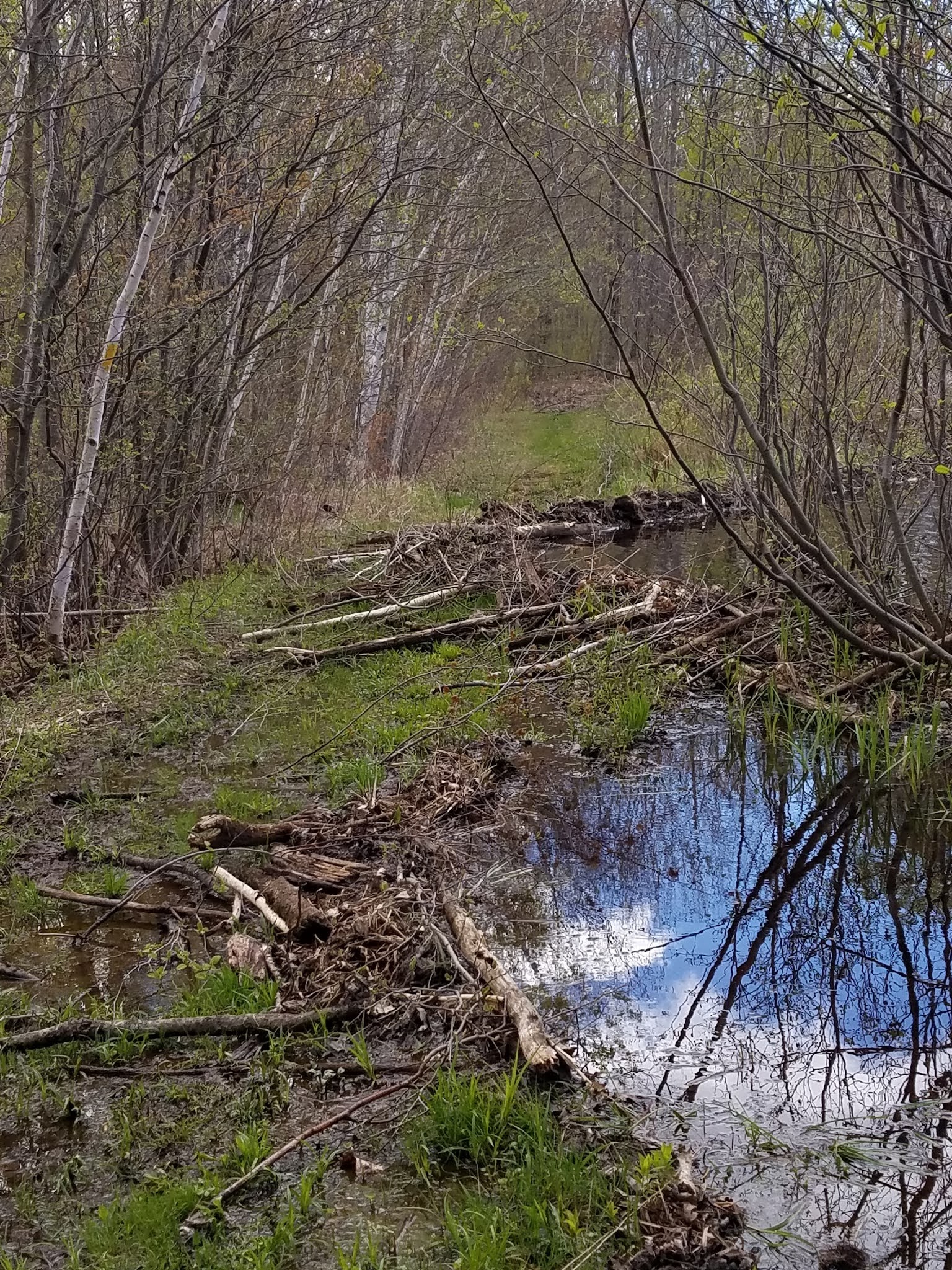

Another look

The end result, of course, is exactly what I'm looking for when I go hiking. If I'm not out there encountering a beaver dam or two, what is the point? I approve, little beaver. Chew on.


Note the Beaver Lodge, back right


Eventually we reached a spot, right about N 45 37.874, W 91 51.535 I think, where we encountered a sign offering us a choice between the Yellow Trail ('Sidehill' trail), or the White Loop, described as the 'even trail'. I believe we have hiked enough hillside trails, with most of them causing erosion. That made the 'even trail' the better option, and I encourage anyone else to take that option, too. The hillside trail runs just a few yards down the hill, and the view is better from the top. Plus - there's a bonus bench. A perfect place for lunch, and we took advantage of it.


Take the White Trail!!!

Of course, while we were hiking, we were enjoying the myriad spring wildflowers. One in particular we're always waiting for, though, is the explosion of Trillium that blankets parts of the Wisconsin northwoods in early May. This year they seemed just a bit late, and they were just starting to open. 

Trillium, just coming into bloom

We also encountered wood anemone, and partridgeberry, and one new one for us, the Early Meadow-Rue. 

Early Meadow-Rue (Thalictrum diocium)

Wood Anemone (Anemone Quinquefolia)

Wood Anemone

Partridgeberry

If you're studying the map, rather than just hiking the trail from sign to sign no matter what comes your way, you'll see an odd bump in the trail as it nears the Washburn County Line. What could have been a straight 280 foot walk along a hillside instead becomes a half-mile loop trail that does... nothing. 


Seriously. Most of the time when I see things like this, there is a reason for it. You're avoiding a hill, or a pond, or a bog, or private property, or something. But here I could find no reason at all to hike the extra half-mile. No pretty view, not even a big erratic boulder. If I ever go back I'm going to bushwhack it.

The condition of the trail for the final 3/4 mile or so are not as easy-going as the earlier walking. If you're hiking east to west, you'll find a lot more roots and rocks out there, and the trail is more of a traditional footpath, which is fine. Not all trails should be carved with a bulldozer. There are enough blazes out there so that you don't get lost, but some of them are getting a little old and weathered. Sounds like a good Eagle Scout project. 

The final 0.4 miles were a dance across the border between Washburn and Barron Counties as we hiked past a line of blue-blazed trees marking the county line. There is no real significance to this. The deer don't care. Neither did we.

We did see this, though, as we passed a tree. I don't know the origin, or the story behind it. Just one more unique thing along the IAT.

Random trail decoration

We reached the western trailhead on Shallow Lake Road, and then turned right to cover the 0.2 miles of roadway that isn't officially a connecting route. Along the way we spotted an osprey nest up on the power lines. 

West trailhead

Osprey Nest 30th Ave & Shallow Lake Rd


When we got to the van to end the first part of the hike, it was 2:35 pm, and 48 degrees. We had a little less than two hours to retrieve our van before it got locked in. We didn't dawdle.

We started the second part of our hike at County VV at the designated parking area, and were just about to take off when another vehicle came flying in, and four people piled out. 

"Are you going this way, or that way?" I asked, pointing both south along the connecting route and west to the trail we were about to hike. 

The woman gave us a bewildered look and said, "We just want to hike the Ice Age Trail. Do you know where it is?" Fortunately, things weren't as dire as they seemed. After a short conversation it became obvious that the two younger people were experienced hikers, and the two older people were just along for the ride and the walk. We started out at 3:07 pm, temperature 51 degrees, just ahead of the group of four, and they quickly overtook us as they took a determined pace along the trail.


In fairly short order we came to Cub Camp Road, and hiked past a couple of the signs for the Boy Scout Oath, then down past Bass Lake where scouts at camp do much of their fishing, swimming and boating. Then it goes up the hill until it reaches one of the many sleeping encampments, and then onto the U-shaped road that passes along the south edge of the property. This part of the trail, from the lake up to the top of the hill, may be one of the only parts of the IAT that is neatly lined by logs on both sides of the trail. Leave it to the Boy Scouts.

Then, a little further along the dirt road, I looked over a hill and saw - an airplane. I have no idea how long it's been there, but I can only imagine the ghost stories and legends that are told around the campfires. 

An airplane? 


The rest of the hike was uneventful, strolling along a two-lane through the woods. We got to the car at 4:00 pm, with the temperature down to 51 degrees. We waved as we drove past the camp administration building, and called it a day, heading back to camp, where we enjoyed a beautiful, but windy evening. Below is our view from the campsite as we looked west across the lake. 


Eagle Point Campsite View

View from Eagle Point Campground

Running Total: 424.7 miles of trail covered; 37.5 miles ‘extra’ hiking/biking. End of Day 61.

.
.
.

.

Thursday, May 6, 2021

Day 60: Grassy Lake Segment, Washburn County

Day 60: Thursday May 6th, 2021

Total Miles covered for the day: 8.5

Location
: The Grassy Lake Segment, between Pershing Road to the west and 30th Ave to the east. 

This was our longest hiking day since September 7, 2013, and our fourth-longest hiking day ever. When I stop to consider we're both a little heavier and a lot older, I feel a little bit proud of our accomplishments today.

Last night we drove out to beautiful Eagle Point Campground in Cumberland, WI, and set up our tent. Except for the Camp Host, we had the entire point to ourselves, complete with hot showers. Eagle Point is an excellent place to camp when it's empty, but it may feel more crowded when it's full, which I've heard starts about Memorial Day. 


Anyway, when we woke up the temperature outside was a decidedly nippy 35 degrees, so it took both self-motivational talking and the call of nature to get me out of my sleeping bag. Breakfast was cold eggs and hot coffee, and we were soon on our way.

We reached our drop site on Lehman Lake Road and left our target vehicle in the parking area in front of the gate, then drove to our launch site at the east trailhead on 30th Ave near Shallow Lake Rd. The time was 10:15 am, and the temperature had risen all the way to 51 degrees.

The first thing we saw was a big, beautiful new trail sign, welcoming us to the segment. Duly welcomed, we headed west, or northwest, to be more specific, intent on covering this 5.7 miles of trail fairly early in the day. 

What we found, besides Trout Lillies, Bellworts, Hipatica and the first blooming Trillium, among other flowers, was a broad, easy-walking trail that provided almost no hinderance at all to leisurely strolling through the woods. The trails were manicured, and there was little in the way of hills. 


Anemone Trifolia
Bellwort

Which is not to say that the entire hike went that way. In fact, there were perhaps 15-20 areas that were a little muddy to a lot muddy, and would present difficulties depending on the amount of recent rainfall, and 2 or 3 areas that were basically ponds laying across low spots in the trail and probably hosted minnows. I've seen worse, but sometimes it would make sense if the people doing trail maintenance would just cut a little trail to go around these things rather than making the hikers pick their way around. 


One of many 'grassy lakes', but not THE Grassy Lake


Another obstacle we faced were the beavers, or more precisely the results of their relentless efforts to remake the landscape to their own liking. As far as I can tell, the only animals more adept at making the environment more inhospitable to other creatures are people, and for that reason alone I admire the little varmints. Mankind deserves a little payback for what we've done to the neighborhood. 


Marsh Marigolds


Have you ever noticed along the trail, when you're walking between two close ponds on an isthmus of land that is more likely than not the remnants of an old beaver dam, that there is a trail cut across the land between the two ponds? This trail, as wide as most deer trails and usually more thoroughly trampled, is a beaver trail, left behind by the constant foot traffic between the two waterways as often as not dragging branches along behind and underneath them. I saw one such trail that was blocked by a recent tree-fall, and I set about sawing off a chunk of tree and getting it out of their way. Oh, I know they would have gotten to it eventually, but I thought I'd give the little flat-tailed, buck-toothed critter a hand. It gave me joy.


There was one spot in particular, N 45 38.883, W 91 53.093 or thereabouts, where recent damming activity had basically extended the lake across the trail. The only way through, because there was lake on both sides, was to walk across the top of the thing, keeping balance in the parts that were thin, in a zig-zag pattern, until dry land was reached on the other side. To be perfectly honest, the workmanship on this bit of dam was a bit slipshod. I can only hope that in the intervening days between when we crossed it and when this was published that there was a rodent repair crew dispatched to shore things up a bit. Otherwise this crossing could get a little wet.


Walking side to side across the trail

And we weren't done with the beavers yet. There was one spot, the exact location escapes me, where the view we got looking down the trail was a lake - at eye level. We were down here - the lake was up there. It was clear from our approach that beavers had, perhaps not too long ago, succeeded at raising the lake level up several feet, obliterating what was once a logging road, or snowmobile trail, or whatever it was that was first laid down, and upon which we had been walking. This was the one place where the trail took a significant detour through the woods, and the quality of the footing fell from a Grade A walk in the park to a Class C goat trail, discernable only because of the yellow blazes and the many travelers who have scuffed the roots and trampled the dirt into mud. 

However, all bad things came to an end. When we got clear of the lake, we returned to the wide and orderly trail. It felt like we had been marooned on an island for weeks, only to be picked up by a luxury cruise ship, or climbing out of a cave into the bright sunshine. it was welcome, though somehow a little disorienting.

Coyote Scat

Another very grassy lake

Fiddle heads


As we headed west, we hit a T-intersection where the trail used to go north to connect with the Shingle Camp Fire Lane, but now cuts to the south. The view of the lake is quite beautiful, if you're into pristine lakes surrounded by natural forests and wildflowers. If not, well, maybe hiking the IAT isn't for you. The rest of the hike, even before it finally got to Shingle Camp Fire Lane near Lehman Lake, was on a broad road that was frankly a lot nicer than some of the 'roads' we've driven down to place vehicles at one end or the other of a segment. Reaching Shingle Camp Fire Lane wasn't even that big a deal, except that it meant we were nearly done with the first part of our trip.


We reached our waiting vehicle at 3:20 pm, and the temperature was up to 55 degrees. It was exactly at this moment that I realized if we wanted to hike the remaining 2.8 miles and finish the segment, we had hiked it backwards. After some rest, a little lunch and lengthy discussion, we determined we would go ahead and finish the segment. We drove to Shallow Lake Road, picked up the other car, drove straight back to the parking area on Lehman Lake Road to drop our target vehicle back off, then drove to the west end of the segment on Pershing Road. 

This part of Grassy Lake proved to be relatively uneventful. It wasn't hilly, it wasn't filled with lakes and beaver dams, there weren't any hemlock stands or pretty streams, but it was a nice, easy walk on a broad snowmobile trail. 

There was one fairly memorable spot. Right around N 45 39.698, W 91 58.505 on the trail, where a short well-worn path leads to a bench overlooking an unnamed lake some 30 or 40 feet below. Many people have made this very short side-trip, and many lucky through-hikers have discovered that 20 feet from the bench is a flat piece of ground begging for remote camping, a spot that is not on any map. If you are reading this blog and choose to take advantage of this spot, please leave a comment. 

Of course, on the opposite side of the trail, somewhere along here, there is supposed to be a spur trail that would allow you to walk up to the edge of the namesake for this segment, Grassy Lake, but we didn't see it, and we never saw Grassy Lake, either. We saw many lakes, and many of them were quite grassy, but the official 'Grassy Lake' of IAT fame will remain forever a mystery and a legend to us. 

A very gloomy and creepy puddle


A bit further to the north, about halfway through the hike, the trail cuts severely to the east (as we were walking) where it heads generally, if not doggedly, eastward until it unceremoniously ends at Lehman Lake Road. Like the north/south part of the trail, it is broad and flat, with unspectacular views, and very little wet or muddy terrain. 


Impressive ancient tree roots at the corner

Nevertheless, when we reached our vehicle and connected the dots, we had effectively extended our St. Croix line another 8.5 miles to Shallow Lake Road, and completed nearly all the hiking in Washburn County, save for little bits in the Bear Lake segment and in Birchwood at the north end of the Tescobia Trail segment. That was worth celebrating. 


It was 6:15 pm, and it had been a long walk. Time to go to the campsite. 

Running Total: 419.3 miles of trail covered; 37.5 miles ‘extra’ hiking/biking. End of Day 60.

.
.
.
.

Sunday, May 2, 2021

Day 59: Parrish Hills Segment (Part 3), Langlade County

Day 59: Sunday May 2nd, 2021

Total Miles covered for the day: 4.5

Location
: The easternmost 4.5 miles of the Parrish Hills Segment, between Nelson Firelane to the west and County Road T to the east. 

4.5 miles of trail covered

One year ago we were walking on the Ringle segment in Marathon County on what turned out to be one of only two days' hiking in all of 2020, the year of the virus. Uncertainty, prudence, precaution, and a shortage of toilet paper made us put a pause on our Ice Age adventures, and we hunkered down with the rest of the world until we figured out what was what. 

This year, with renewed information, increased stability, and most importantly a vaccine, we have refocused our efforts on the trail. Today we decided to go back up to Langlade County and finish up the last 4.5 miles of the Parrish Hills segment. 

We had already hiked the western 7.5 miles of Parrish Hills, from the Nelson Firelane to the western trailhead, with a lot of relatively easy hiking on logging roads, snowmobile trails and gravel roads, along with quite a lot of 'normal' hiking trail. Easy except for the 'hills' part. There were a lot of those. And the driving. There was a lot of that, too, and it was memorable.

Today's target was the last 4.5 miles east of Nelson Firelane. Which meant we needed to get a vehicle down that forsaken piece of gravel back to the trail crossing where we started the last time. Having already gotten to that crossing once, we knew it was no easy feat. The last time we drove in on Five Cent Road from the west end, then driving down Nelson Firelane to the trail intersection. Simple. However, I can say with confidence that neither one of those roads was built with the likes of a Chrysler Town and Country in mind, let alone the low-slung fuel-conscious Toyota Prius, better known for traversing parkways and parking lots in Eco-Mode. And if you read our previous blog on Parrish Hills, you'll know that we decided to drive OUT of that spot by heading due south, which we swore we would never do again. The last time we drove down that road I had to get out twice to saw through trees that had fallen across the road and hadn't been cleared yet. If we had broken down, there would be no thumbing a ride any time soon. 

Today the plan was to repeat our previous journey, going 3.5 miles along Five Cent Road, heading South on the Firelane, going down and back up that one rather alarming hill in the road, parking our car, and reversing our way back out of there, all the while dodging the ATVs who used the road a lot more than anything without four-wheel drive. And it almost worked. We made it down 3.1 miles, only dodging about 6 ATVs, when we reached blue tape strung across the road with a sign that said 'Trail Closed'.

It says something, I suppose, that the sign didn't say 'Road Closed'. Still, it was technically a 'Road'. It said so on the signs. I decided to walk down and see why they would close a road to ATV use. Certainly we could just slip in, drop a car, then slip out again and no one would notice, right? Unfortunately, anything that would close a road to an ATV proved more than enough obstacle for my humble mom-car. A washout just down the road made the whole thing impossible. But - rather than dropping the car where we were and adding 1.5 miles to the hike, which was already going to be touch-an-go to avoid the rain, we decided to go back and drive back up Nelson Firelane from the south. 

Which we did. And it was just as awful as we remembered, only this time we were driving the worst of it going uphill, and not down. We were passed by numerous ATVs, heads turning and wondering what we were doing there as we scrambled along. We wondered the same thing.  

My minivan has reasonably good clearance to go over the ruts and boulders sticking up out of the road. The Prius does not. Theresa made it through, though I don't know how she did it without tearing off the heat shields and the muffler. We finally were able to drop the van off at the trail intersection, wanting to get the Prius out of there before the rain hit. That could spell disaster. 

So we had a decision. The devil we knew, or the devil we didn't know. We knew already how horrible it would be driving back out to the south. We knew we couldn't go back out the way we intended originally due to the washout, but that left the third option, going back up to Five Cent Road and turning east, driving the 3.5 miles in the other direction, then headed south on West Elcho Road until we hit Line Road and finally County Rd T. We reasoned that if we went out to the north and east, at least we would be driving on 'Roads', and not on the Firelane, so we went north and east. 

We have driven a lot of bad roads. The Ice Age Trail helped us find many very bad roads in our quest to cut long segments into shorter hikes. We have never, and I mean NEVER, driven a worse road than this one. The first mile or so wasn't too bad. Then there were bad spots. Then there were worse spots. Finally, there were places where we had to decide how hard to bottom out the vehicle while we fought our way up loose gravel, stones and rocks that littered the ruts and washouts in order to prevent not making it to the top of the hill and having to back down and try again. 

"How much farther?" Theresa asked. I shuddered to answer. "1.2 miles, then we hit West Elcho Road. It should be better from there."

Except that it wasn't.

When we finally reached West Elcho Road, our imaginary byway of civilization and salvation, we found ourselves on yet another unloved and neglected gravel backroad, too beat up and unworthy to even qualify for the state's 'Rustic Road' designation. We soon found ourselves crossing a swamp with logs - literally LOGS - laid down perpendicular to the direction of travel, upon which gravel had been tossed during a presidential term that preceded the birth of BOTH of my last two minivans. The logs were laid as foundation to the road to prevent it from sinking into the swamp, and I guess I can be thankful that they had survived long enough to save our Prius from a similar fate. By the time we reached County Road T, and the eastern trailhead for Parrish Hills, we were literally two full hours past when we thought we would be starting our hike.

So let me start by saying, if your thought is that you want to use Five Cent Road to cut your hike in pieces, you have many choices. But unless you drive a truck with some attitude - don't. Just - don't. It's not worth it. You can get there faster by just walking. There is no 'good way' to get to the Nelson Firelane, and Five Cent Road is nothing more than a one-lane playground for ATVs. 

OK - time for a deep breath - the Parking area at the Eastern Trailhead, which is located at the Townline Lake wayside on Cty Rd. T, is glorious. There are picnic tables. There's a pit toilet if you look for it. Lots of parking. Families with children. Fish jumping out of the crystal clear lake. It doesn't get any better than this. 

After taking a moment for a mental adjustment, we geared up and started our hike at 11:45 am, the temperature a warm and friendly 68 degrees. Any hope we had of beating the rain that was forecast to start by 1:00 was completely out the window, but we had raingear, and we were off.


The first thing the trail does is head north along Townline Lake. I have to say this was a missed opportunity by the IAT trail-makers. Here was this beautiful lake, with a nice hill that traveled along the eastern shore, and rather than work the trail to the top of the hill, they chose cut the trail into the edge of the hillside, 30 feet from the top of the hill that was only about 15 feet higher in elevation. The trail slanted mercilessly, except where the erosion had exposed tree roots and other problems, and the entire walk along the lake was spent taking care not to lose your footing or twist an ankle, rather than enjoying the view from the hilltop only a few tantalizing feet away. 


I'm not going to say it was all bad. In fact, the hiking along this section was mostly on very good trail, or on logging roads or the like, with great blazes and all the trees and debris cleared away. 

After a mile or so, we encountered Thank God Bridge, which you will recognize and appreciate when you get there. At some point in the past, trail angels toted in the lumber and hardware necessary to build it, and I shudder to think what it would have been like if no such bridge existed. Truth be told there are many such bridges scattered across the IAT, hundreds of them, and if not for the work put in by those work crews we would not be able to enjoy the trail like we do, and we probably would have given up long ago. 

A couple of times the trail went straight across a mucky area while the main road went around. We went around. We're literally talking 150 feet. Unfortunately, the mud was not always avoidable. 


We had reached the center 'Troad' portion of the hike, comprised mostly of two-track trail/roads. The blackflies were out, and first of the deer flies. Deet kept them at bay. 

The trek to the west took us across several miles of stony logging/atv roads. We found little in the way of trash, unless you count all the 20-guage shells left behind by the grouse hunters. It wasn't particularly hilly, but then walking on roads can tend to hide the hills a bit. There was another problem - gravel roads can sometimes be difficult to walk on, and are harder on the feet than trails. I prefer a dirt trail to a loose gravel road. 

Of course, hiking roads that are sometimes muddy has other benefits. You get to see tracks from the critters that go through. We saw turkey tracks, deer tracks, and one particularly large dog track. I'm saying dog. A big dog. A dog that leaves tracks the size of the small plates in the cabinet. OK, it was a wolf. 


Cool.

When we walked past an enormous clearcut from about 5 years ago, now filled with a hundred thousand aspen trees, we heard off in the distance a woodpecker drilling test-holes. The loud, resonant thud-thud-thud was not the normal, frenetic steady hammering, but more of a tentative tapping, as though the motor wasn't quite catching and it sputtered to a stop.  

Finally, after what felt like miles of gravel road (because it was miles of gravel road) we spotted the place where trail left the troads for good and bounded off north through the woods. The turn was easy to identify, because the blazes were excellent, and I'll give one more set of kudos to whoever went through here with yellow paint. Whether it was signposts, tree paint, or even paint on rocks on the ground, they made sure there were enough blazes to keep you going the right way. Well-done.

What remained was not a bad hike. I remember seeing all the typical flowers, and took one nice photo of a blood root plant in full bloom. 

A lot of the time was spent hiking the top of a very narrow ridge. At times the ridge was so narrow you could stand in one place and see all the way to the bottom of the valley on both sides. If not for the trees, you would call it an arete. It was that severe. 

Then, on the final westward march, we passed through a stand of young trees that were parted like the Red Sea, forming a wall the left and to the right, 


A few short tenths of a mile later, and we reached our waiting van at 3:00 pm, somehow having avoided the predicted thunderstorms, with the temperature a steady 69 degrees. 

We walked across the road, touched the sign, and connected ourselves all the way to Cornell in Chippewa County. 

Despite all our promises to self, we turned the van around and drove right back down that horrible Nelson Firelane, ruts, rocks and all, for the fifth, and, God as my witness, LAST time. 

Of course, when we got back to the trailhead, we walked across the road to take a look at the trailhead for Highland Lakes going the opposite direction. There we saw a painted rock, sadly broken, with the saying, 
IAT Highland Lakes Western

Of all the paths you take in life, make a few of them dirt. 

 
Sage advice. 

Running Total: 410.8 miles of trail covered; 37.5 miles ‘extra’ hiking/biking. End of Day 59.

.
.
.

.

Saturday, May 1, 2021

Day 58: Chaffee Creek Segment, Connecting Route, Wedde Creek Segment, Waushara and Marquette Counties

Day 58: Saturday May 1st, 2021

Total Miles covered for the day: 4.4

Location 1
: The Chaffee Creek Segment, between the I-39 wayside to the south and Czech Ave to the north. 

2.5 miles of trail covered with 0.6 miles extra hiking.

If you are ever given the opportunity to introduce someone to the Ice Age Trail - take them on their first introductory hike, for example - you should not, under any circumstances, take them to this segment. It wouldn't be fair.

It wouldn't be fair, for example, for them to walk along grassy, soft-footed trails, through picturesque and quiet wooded areas bordering stereotypical farm fields, with ecologically-minded paths making for easy climbs and descents, along a creek so clear you can count the pebbles on the bottom as it ripples along, through an idyllic copse of trees in the most unlikely of locations, only to cross the creek on a sturdy bridge complete with stairs before meandering through a field and to the waiting car, with flush toilets and vending machines waiting at the end. 

No, it would not be fair to them at all. It would be cruel to give that first-time hiker the impression that this is what the Ice Age Trail is like. It would only serve to draw them in, lulling them into a sense of comfort and longing that can only be satisfied by finding out what the next segment is like... and the next... until they, too, have a set of 105 colorful maps, with bits and pieces highlighted in different colors and dates noting when they were there, quietly muttering to themselves about how you suckered them in with this magnificent hike.. 

No - if you have the chance to take that new hiker on the trail for the first time, be kind to them and take them anywhere but here. 


The Chaffee Creek segment crosses under I-39, straddling then crossing the line between Marquette County to the south and Waushara County to the north. You would think this would make it easy to do a 'quick hike', dropping a vehicle off on one end, then popping over to the other end and hike away. You would think so, but you would be wrong. 

We looked at this inconvenient little segment many times, not quite sure the best way to deal with it. The problem is the southern end. It's located at a Wayside. On the I-Road. With no way to backtrack, and no easy way to get vehicles on both ends. 

One option, of course, is to walk in opposite directions, wave hello as you pass in the middle, and trade vehicles. Efficient, but not what we wanted. Another option would have been the out-and-back, a tried and true method used by many, that would have effectively doubled the distance. Then of course there's the third option of just going through the pain of dropping a vehicle at one end, driving to the other end and walking between, but that takes literally an extra 45 minutes of driving because of the complication of the highway. A fourth option would have been to use the short 0.2 mile blue-blaze spur trail at the end of 6th Avenue, walk the 0.6 miles down and then the whole segment to the north, shortening up the driving considerably but adding that extra 0.6 miles. A fifth option would have been to split it into two days, one day being an out-and-back hike of 0.4 miles from the Wayside to the intersection with the blue-blaze trail on some day when we happen to be driving through. We would have done that, too, except the day we stopped to do exactly that, there was so much poison ivy along the path we decided to skip it.

What we finally decided to do was to have one vehicle, mine, go to the Wayside, and have the other vehicle, Theresa's, go to the end of 6th Ave. I then hiked the 0.6 miles to the waiting car, and we drove to the north end of the segment on Czech Ave. and hiked the entire segment going north to south. 

This meant that only one of us had to walk the extra 0.6 miles, and even though this still meant a full 20-minute drive to get from the Wayside back to where we parked our launch vehicle, that time was our typical take-a-break time between segments where we relax a bit and get a snack and a drink. 

It was somewhere around 11:30 when I reached the wayside. I had already made careful preparations and was able to simply grab my waist pack and hiking stick and go. I wasn't really tracking time and temperature, because this was all the 'extra' hiking, and I would be coming back the other way with Theresa, and for a bonus, with our daughter Nicole and her wonder-dog Joplin. This part didn't really count.

Because of the twists and turns to get down to 6th Ave., I was able to get to the waiting car no more than 5-10 minutes after they had arrived. Then we all drove to the north Trailhead on Czech Ave where we snugged our car alongside the road and geared up. 

We started the hike at 12:00 sharp. The temperature was only 69 degrees, but the forecast was much warmer. 


The first part of the hike, going north to south, is a straightforward southward march across two tenths of a mile of open field, which at this time of year wasn't bordered by encroaching crops. It afforded a view to what lay ahead, a patch of forest that had not been converted to crops. Once again, I am in great appreciation of the farmers who allow a trail to cut through their fields, because it takes up an appreciable swath of land that is therefore not growing crops, which is money out of their pocket. Add to that the inconvenience of having to avoid plowing the trail and the sacrifice is even more noteworthy. 

Once we reached the woods we walked west across the face of it a bit then ducked in, headed south, and we noticed immediately that we were no longer walking through the great northern forests. Chaffee Creek is in Sand Country, and the trails show it. The walking is easy, the trails soft beneath your feet. 


I stopped to pick up a geocache while I was in this first piece, and we were through it in no time. By the way, if you are picking up the geocaches as you go on this segment, you're better off hiking south to north. You're welcome. 

Then, as we were leaving the woods to hike across the small piece of field in the back, it became apparent just how much effort was given on this well-maintained segment to providing easy walking. It would have been really easy to just march straight across this piece and have a short, but steep climb up from the field on the other side. Instead, the trail cuts far to the west to make the incline far less steep and nicer to hike. 


Somewhere along the way, we passed into the Mecan River State Fishery Area (older maps incorrectly label this the Chaffee Creek State Fishery Area). We followed the easy trail through sparsely forested, sandy soil, stopping once for a rest on a bench located at N 43° 59.128 W 089° 29.165. Then we were off again.


As we approached the northbound highway, with its ever-present drone of vehicles moving past, we came out of the woods and found that the ground beneath our feet became... weird. It felt rubbery, like we were walking across the surface of a balloon full of water. It wasn't wet at the surface, but you could tell we were stepping on a floating mat of soil and vegetation. 

Then we got to the creek, and Joplin (the dog) was really happy for it. She plunged right in, taking long, sloppy gulps of water, because the temperature had climbed up pretty significantly. It was nearly 80 degrees already, and it wasn't even 2:00 yet. 


Another benefit of Sand Country is that the water is clean and clear. I could see every detail below the swift-running surface. There's just enough silty mud to make it not too easy to get in and out, but it would also be very easy to get fresh water here in the event you don't want to wait the 20 minutes to get it at the wayside. 

The walk below the bridge was as you would expect, but immediately on the other side, between the northbound and southbound highway lanes, is a magical little copse of woods that you would never expect. There is a geocache in there as well, and probably the only one you will ever get on DOT land in Wisconsin. 

Then came the biggest surprise of all. As we approached the second highway underpass, we saw, not a bridge, but a culvert. A big, whomping-ass culvert that burrows beneath the highway, and has a rip-roaring creek running through the middle of it.

What the...? And yes, there too was the IAT sign, a little arrow fastened to the edge and pointing inside. 

Seriously? 

We had to get VERY close before we discovered that instead of having to slosh our way through the creek as we feared, there was a narrow sidewalk that ran along the creek on the inside, mere inches above the surface of the water. 


The photo doesn't give you a good enough picture of what you're dealing with. If it had been a little more rainy recently, the water would have been up and over the concrete, and there would be no way to stay dry. Word to the wise - if it's been rainy at all, you may want to choose to hike this one south to north to assess if you think this is passable. Or else, bring your water shoes. And I personally wouldn't want to walk through there if the concrete is below the waterline. That's a good way to turn into flotsam. 


Shortly after emerging from the tunnel, we met a couple who were hiking an out and back. I asked if they had ever been on the segment before, and they said no. I grinned, and told them that in about 100 yards or so they would see something that would make them stop in their tracks (see above image). But I shared with them that it would be OK, and they could keep going. I still wish I had been there to see how accurate I was.

A very short while longer we reached the intersection where the spur trail goes to 6th Ave, but per plan we hiked as a group southward, crossing the river one final time on a beautiful permanent bridge. The trail here, by the way, dances across the Waushara/Marquette County Line a few times as it goes beneath the highway, but once having crossed the bridge, we were in Marquette County for good. The trail comes out of the woods, and meanders through a large, grassy field, through an ancient gate (we guessed 50 years, at least) that was no longer functional, and along the exit ramp for the wayside. Two tenths of a mile later, we reached our destination. We touched the sign at the wayside at 1:57 pm, and the temperature had officially reached 80. This completed Marquette County for us.

On to the next location. As planned, we drove the 10 minutes south to Westfield to take the first available exit, then worked our way back north to the next hike.


Location 2: The Connecting Route between the Chaffee Creek Segment to the west and the Wedde Creek segment to the east, along Czech Ave, Waushara County

0.7 miles of trail covered.

There isn't a whole lot to say about this piece, because it's a 0.7 mile paved road that runs in a straight line. So instead I'll mention all the wildflowers we saw on the previous hike. Hepatica, lilac, wood anemone, spring beauty, strawberry, blood root, trillium, and many more. 

We also saw butterflies, which have come out in abundance in the last seven days. And so have the ticks. Mother nature always tosses in a few thorns with the roses. 

We hiked this stretch between 3:30 and 4:00, and the temperature had reached 86 degrees by the time we were done. May 1. 86 degrees. Sheesh.

Location 3: The Wedde Creek Segment, Waushara County

1.2 miles of trail covered.

To be perfectly honest, we walked this in two pieces. And there's already more to the story.

When we drove north from Westfield, we took the path on the east side of the highway, and ended up blowing past the turn on Czech Ave, and then even past Cypress Road, driving almost a mile and a half north along the connecting route before we realized we had missed the turn. A minor inconvenience, but on the way we passed a south-bound solo hiker enduring the heat and the roadway. After we turned around, we decided to pull over and ask how she was doing, if she had enough water, that sort of thing. 

As it turns out, though she had the appearance of a through-hiker, with all the gear, she was out on day 2 of her first solo overnight hike. Let me just say that I completely understand her trail-worn appearance. It was getting ridiculously hot for May 1, and she was walking in the sun on the highway carrying a BIG pack. In the end, we only gave her some dried banana chips, which she dug into as we drove back to our intended starting location. 

We parked along Czeck Ave at the intended Parking area for Wedde Creek, which actually sits in the middle of this extremely short segment. We hiked the very short spur trail (less than a tenth of a mile) and hiked the 0.4 miles to the west between 2:54 and 3:30 pm. This piece of trail, though a tiny bit more hilly than Chaffee Creek to the west, was nonetheless gorgeous and easy walking, with trees, flowers, birds - all the good stuff. 

As we hiked, the temperature continued to climb, rising from 83 to 86 degrees in that span. 

When we finished, we continued westward along the road to do the connecting route (see Location 2 above) before reaching our car and repositioning ourselves for the other half of the Wedde Creek segment. 

We managed to park our vehicle near the north trailhead on Cypress Road, which was no small feat. We were headed north to south. The time was 4:15 pm, and the temperature had reached a humid and generally unpleasant 89 degrees.

It was in incredibly pleasant walk but for the heat. There is a bridge across Wedde Creek, though it is in very bad shape. Wedde Creek was interesting, another fast-flowing clear creek, but the mud here was a little more prevalent, and the creek pushed a broad and winding split-channel through the bottoms. There were marsh marigolds a-plenty, and we also saw a significant quantity of skunk cabbage, showing that the area stays very wet most of the year. 

I'm told that if you hard-boil skunk cabbage through several cycles of boil-rinse-dump-refill and boil again, there are parts of it that won't burn holes in your tongue when you eat it. Let me know if you every decide to try that recipe.

There is another geocache along that creek, too, but there was far too much mud and water for me to get out there and find it. 

Again, the trail here is absolutely wonderful. If it weren't for the heat and the newly emerging black flies it would have been perfect.

We finally ended our hiking day at 5:00 pm, and the temperature was finally dropping - to 88 degrees. 


Running Total: 406.3 miles of trail covered; 37.5 miles ‘extra’ hiking/biking. End of Day 58.
.
.
.
.