Day 61: Bear Lake Segment, Barron (and Washburn) Counties
Day 61: Friday May 7th, 2021
Total Miles covered for the day: 5.4
Location: The Bear Lake Segment, between 30th Ave to the west and 16th Street/Cty VV to the east.
I remember one time back in the late 1970s, or possibly in 1980, when I jumped in a vehicle along with some 30 or 40 of my friends to caravan up to the L.E. Phillips Scout Reservation for a week-long camping trip. Seeing as this was a full 40 years ago, the details are a bit vague for me, but I do remember it as being an unusual trip for our troop.
The camp, more commonly known as 'Camp Phillips' had the reputation of being a place where scouts go to earn merit badges. Our troop, Troop 102 in Madison, WI, was a highly active bunch of kids, mainly because we had an amazingly supportive and active group of adults making it possible. For seven straight years, from the day I turned 12 until the day they kicked me out at 19, we went camping literally once a month, rain or shine, winter or summer, and it was always 'high adventure'. Canoeing was a staple. So was hiking, though less so. In the winter we would often get barracks, or some other reasonable shelter and go cross-country skiing. Sometimes that meant only a wood stove for heat. Those were the best. But many, many, many were the times when we would journey out, put up our orange pup tents, and just enjoy the wilderness, deer flies, mosquitoes and all. Back in those days I don't remember ticks being much of a factor.
What made Camp Phillips so unusual for us was that we didn't stay in our own tents. There were permanent canvas tent settlements where we could sleep, and during the day, rather than hiking, or canoeing, or cross-county skiing, the troop broke up into groups to attend 'merit badge sessions', dedicated to satisfying the requirements of the camping, or fishing, or orienteering, or swimming, archery, shooting, or any one of a hundred other badges. And we weren't there alone. What makes Camp Phillips so different is that they have permanent buildings, permanent staff, and they host hundreds of scouts at a time on their 1400 acre wilderness retreat.
So there was plenty of opportunity to interact with kids from other troops, trade badges and lies, have informal competitions, and generally see how much we could get away with under the supervision of our dedicated chaperones. I know we tested them mightily, and not just at this camp. Oddly, though, I had no interest whatsoever in getting merit badges. I already had earned most of the badges that were in the camp program that week, so instead of doing all that pre-programmed activity stuff, I just worked on my fishing merit badge. A lot. Every day I would check out a boat for use in one of the five lakes, and just went fishing, usually by myself. Most days I just skipped lunch. I caught over 100 bass while I was out there, and uncountable panfish. I didn't keep any of them. I just put them back in the water and watched them swim away. I had already earned the fishing badge, anyway.
So all of this nostalgia is stemming from the fact that the Bear Lake Segment of the Ice Age National Scenic Trail walks right through Camp Phillips, along a path that is something less than a road, then trotting off through the woods just when the second set of canvas barracks become visible. During the summer this whole area would be crawling with Boy Scouts and Cub Scouts, but as of today, May 7th, they were not open for business yet so the camp was largely deserted as we drove in.
The entire 1400 acres, and the roads it contains, is a private facility. But I drove in to ask permission to park at the trail intersection, so we didn't have to hike the whole segment at once. As it turned out parking was possible, as long as we were out before 4:30 pm when the gate would be closed. It was only 11:00 - shouldn't be a problem, we thought, and we parked our van and started our walk.
The temperature was a cool 46 degrees, with a persistent though modest breeze that made the extra layer feel good as we walked.
Almost immediately after leaving the van we encountered the long, and slightly worn boardwalk that crosses a peat bog that would otherwise present a serious impediment to hiking. Even on the Satellite Map it's not clear how one would pick their way around that obstacle were it not for this long-ago Mobile Skills Crew project.

From there, the trail becomes pretty easy, often taking the form of a mowed snowmobile trail.
 |
| beautiful trail |
And, as with most trails of this type, there are invariably some low spots that create muddy spots to avoid. The one benefit to this, in my eyes, is that the scouts have the opportunity to use their Tracking skills to identify muddy prints from the many wild animals that frequent these remote woods. I spotted this really clear coyote track and took a photo on the way through.
 |
| Note the nails showing in front of the pads. Also - no distinctive dent in the large, center pad. |
To be honest, I was fooled at first, mostly because I'm short on experience. I thought at first that the rounded toes was an indication of feline, rather than canine tracks. This led me to think bobcat rather than coyote, specifically because the track was quite small. However, a post-hiking internet search pointed out that the marks in the mud in front of the track were clearly claw marks, and no self-respecting bobcat would ever dull its claws that way while it walked. So definitely canine. And as I'm writing this, I have to consider the possibility that this track was left behind by someone's half-schnauzer trail mutt who was just traipsing along as a buddy.
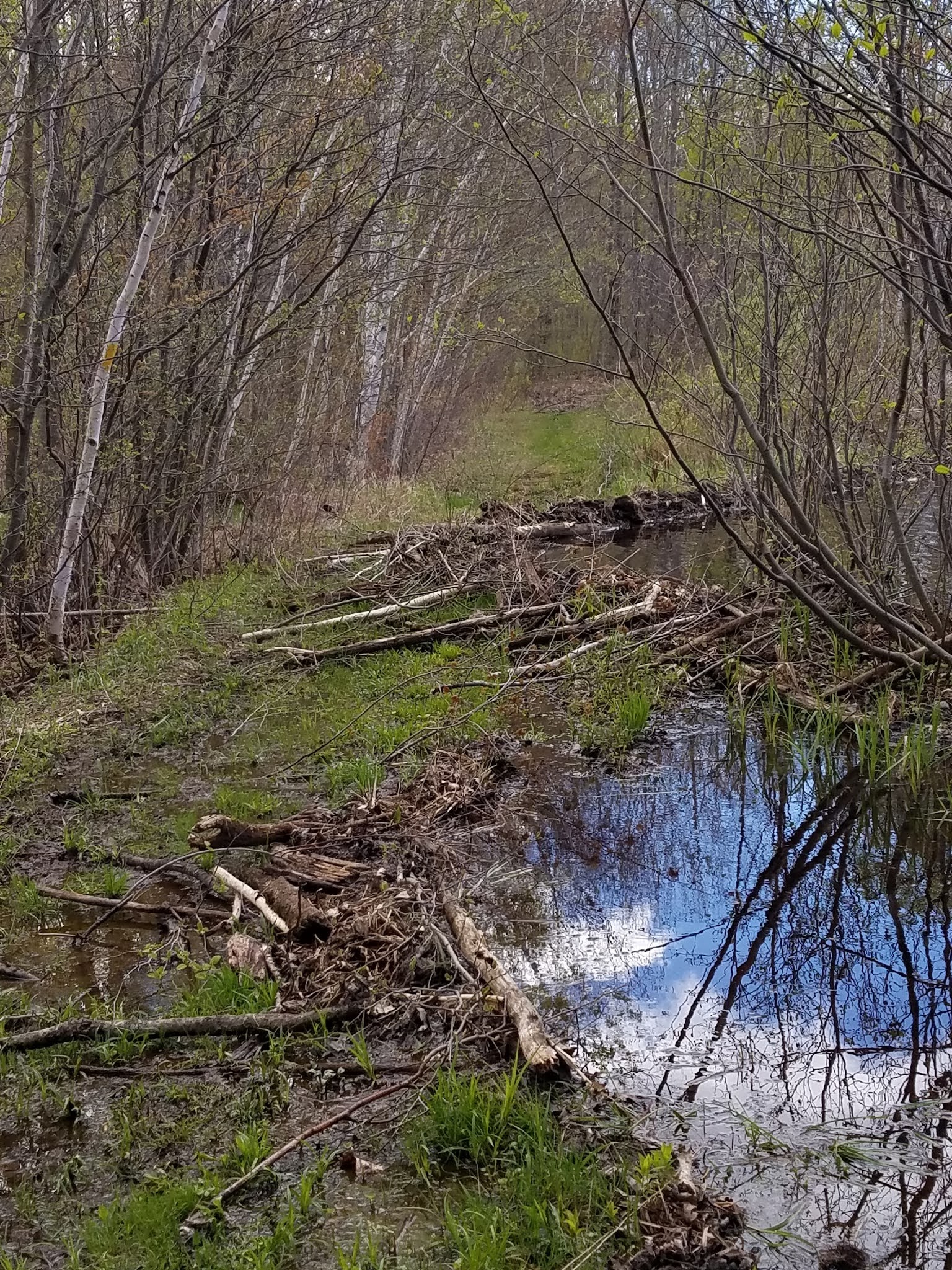
There was one place on the trail where the beavers have decided that the lake level should raise at least as high as the weird, flat, bare area in the forest that the noisy animals walk on.
 |
| Beaver pond where the trail used to be |
In keeping with that decision, the beavers proceeded to build up the trail a bit using their own artistic flair, and creating an environment more suited to their liking - muddy, wet, full of logs and branches, and far more aesthetically pleasing than those unnatural straight lines.
 |
| Another look |
The end result, of course, is exactly what I'm looking for when I go hiking. If I'm not out there encountering a beaver dam or two, what is the point? I approve, little beaver. Chew on.
 |
| Note the Beaver Lodge, back right |

 |
| Take the White Trail!!! |
 |
| Trillium, just coming into bloom |
 |
| Early Meadow-Rue (Thalictrum diocium) |
 |
| Wood Anemone (Anemone Quinquefolia) |
 |
| Wood Anemone |
 |
| Partridgeberry |
If you're studying the map, rather than just hiking the trail from sign to sign no matter what comes your way, you'll see an odd bump in the trail as it nears the Washburn County Line. What could have been a straight 280 foot walk along a hillside instead becomes a half-mile loop trail that does... nothing.

Seriously. Most of the time when I see things like this, there is a reason for it. You're avoiding a hill, or a pond, or a bog, or private property, or something. But here I could find no reason at all to hike the extra half-mile. No pretty view, not even a big erratic boulder. If I ever go back I'm going to bushwhack it.
The condition of the trail for the final 3/4 mile or so are not as easy-going as the earlier walking. If you're hiking east to west, you'll find a lot more roots and rocks out there, and the trail is more of a traditional footpath, which is fine. Not all trails should be carved with a bulldozer. There are enough blazes out there so that you don't get lost, but some of them are getting a little old and weathered. Sounds like a good Eagle Scout project.
The final 0.4 miles were a dance across the border between Washburn and Barron Counties as we hiked past a line of blue-blazed trees marking the county line. There is no real significance to this. The deer don't care. Neither did we.
We did see this, though, as we passed a tree. I don't know the origin, or the story behind it. Just one more unique thing along the IAT.
 |
| Random trail decoration |
We reached the western trailhead on Shallow Lake Road, and then turned right to cover the 0.2 miles of roadway that isn't officially a connecting route. Along the way we spotted an osprey nest up on the power lines.
 |
| West trailhead |
 |
| Osprey Nest 30th Ave & Shallow Lake Rd |


 |
| An airplane? |
The rest of the hike was uneventful, strolling along a two-lane through the woods. We got to the car at 4:00 pm, with the temperature down to 51 degrees. We waved as we drove past the camp administration building, and called it a day, heading back to camp, where we enjoyed a beautiful, but windy evening. Below is our view from the campsite as we looked west across the lake.
 |
| Eagle Point Campsite View |
 |
| View from Eagle Point Campground |
Running Total: 424.7 miles of trail covered; 37.5 miles ‘extra’ hiking/biking. End of Day 61.
No comments:
Post a Comment