Friday, March 18, 2022

 Day 146: Waterville Segment (Part 2), Connecting Route, Merton (Part 3), Waukesha County

Holy Hill Segment (Part 2), Washington County

Day 146: Friday, March 18th, 2022

Total Miles covered for the day: 9.0 plus 0.8 miles Extra hiking

Location 1The Waterville Segment
3.4 miles of trail covered plus 0.8 miles extra hiking

Today was another scheduled Snail hike, and we were looking forward to revisiting the Waterville Segment. We had previously (and accidentally) hiked half a mile of the Waterville Segment when we were doing the Lapham Peak Segment, but today it worked out best just hiking it again. That meant that despite the fact we were walking the whole 3.9 miles of the Waterville Segment we could only claim 3.4 of it as 'trail covered'. But then everything we covered twice became 'extra', and it all counts for our feet. 

We decided we'd play a new game today called 'Catch the Snail'. In other words, I dropped Theresa off at the trailhead about 10 minutes before the rest of the group was supposed to meet us, and I went to the meeting place to organize shuttles. 

I met the group at the large parking area at the Waterville Field Station. Not, by the way, at the large, beautiful parking area in front of the Wildlife in Need Center, but rather further back up the driveway a bit. Apparently that's where they want large groups of cars to park. Basically, if you're not going to the Wildlife in Need Center, they want you to use the extra lot in back. 

I laid out one rule for the hike. No one gets a patch until you Catch the Snail. 

Which was not set up to be difficult. 

So with a couple of vehicles in tow, we headed to the South end of the Waterville Segment, a 3.9 mile walk through late winter Wisconsin. 

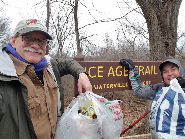
We gathered around the trail sign for the mandatory Group Shot and headed into the woods. It was 9:47 am, and it was a damp 37 degrees. It was cold, but there was no rain (yet). 


Besides the relatively new fence visible in the photo and the relatively new sign, the path had recently been visited by trail fairies, who spread straw at the beginning of the trail to prevent it from getting too muddy. 

Now that's what I call trail maintenance. 

I took my time getting started, letting all the trail runners take the lead. In fact, if they had not eventually caught up to Theresa and slowed down long enough for a patch I might never have seen some of them again. 

The hike started out past a giant oak tree, then down into a marshy area with a series of boardwalks. The person I was walking with, Kevin, is one of the volunteers who take care of this segment and he proudly talked about all the improvements they had made over the last year or so. 

In addition to the boardwalks, for which I was quite grateful, the marsh offered a lot of birdsong. I didn't hear anything particularly exotic, but I was happy to hear birds singing. Perhaps spring wasn't that far away after all.  

There were a couple of benches along the trail, which was nice. Eventually we crossed the creek we had been walking along. 

As we were starting the only real climb for the segment, I heard voices and laughter ahead. Most of the group had caught the snail. It was a merry group, Theresa holding court on her bench (what a beautiful bench that was!) and all the people gathered around. 

Here is: 
Melanie in teal
Pam in purple
Ann in blue
Kevin in green
Cindy in gray
and Theresa, who was inexplicably holding up six trail patches. 

Mary Siekmann was there as well, but she managed to stay out of the photo somehow. She was the one who had hiked with us before, on our Holy Hill hike.


There she is! She's the one in the middle with the green hat. 


Making our way uphill, we picked up about 100 feet in elevation, and had to take a another very small hike uphill to climb up to the Dispersed Camping Area. It was actually a really great campsite as far as that goes, but like many of the DCAs there was a total ban on fires. Even so there was lots of room to pitch a tent, and a nice bench to sit on. 


And through all of this there was the continuous annoyance of the birds. Not that we were annoyed - we loved hearing them. But some of the birds were clearly annoyed, giving out warning and guard calls as we passed. 

And far off we heard cranes and geese, each making their presence known to the other, while we hiked up some nice, new switchbacks on a wide dirt tread. 

Cresting the hill we came out into the open, where there was another commemorative bench next to this small tree, that offered a great view of the field. 


Theresa and the group had pushed on ahead while I brought up the rear with Kevin. We walked into the woods a bit and around a corner before coming to the second DCA on the Segment. This time we had a short downhill hike to get to the DCA, and this site was even bigger, offering room for a large number of tents. 

But still no fires allowed. I don't know about you, but when I go camping I like to have a campfire. Camping just isn't the same without one, you know?


We started hiking through a greenspace between a number of homes, but they weren't very noticeable. Just before getting to the Tallgrass Court road crossing, we went through a red cedar/juniper section that was much more open than the other wooded parts we were walking through. 

The crossing at Tallgrass Court was nice enough, but there is absolutely, positively no parking there. 


The road crossing was followed by a nice, wooded section. In short order we came across the final boardwalk before getting to Waterville Road, and it's a beauty.


The portion of the trail actually ON Waterville Road is only 0.7 miles. We spent it picking up garbage with our new friend Ann. 

After that, the trail goes just off-road to the east, along the front edge of several properties.  


The final leg, about 0.4 miles, was nothing like I remembered it. But then the last time I went through it was practically at a jog, and I was going the other way. Still, I was amazed at how unfamiliar it was. It was mostly level, and walked along the edge of a wooded section, the edge artificially created by an enormous amount of clearing to keep the field section open. 


Then we shot north for the last little push through the woods before reaching the sign marking the end of the Segment. The time was 11:54 am. It was up to 39 degrees, and the predicted wind was almost non-existent. 


We then took the blue spur trail back up to the vehicles and made sure everyone who needed it got a ride. Mary had been waiting there for us, bless her heart, though she had finished long before. She also wanted to make sure people had a way to get to their cars. 

Kevin was done, but Ann decided to join Theresa and I for the connecting route between Waterville and the Scuppernong Segment to the south. Mary wasn't going to join us at first, but when we told her we would help get her shuttled and she could just race off to her car, she got a twinkle in her eye and decided she had time for just one more mile. 

Location 2The Connecting Route between the Scuppernong Segment and the Waterville Segment
1.1 miles of trail covered

I wasn't sure what to call this one, as far as distance goes. The Hiker's Resource Map says it's a total of 1.0 miles. The Trail Atlas shows a total of 1.1 miles. As near as I can tell, Google Maps indicates somewhere in the middle. But heck - with all the extra walking we did on this roadway I'm taking credit for the 1.1. 

Ann, you see, is an enthusiastic trash picker. And since I am prone to picking up a little garbage myself I had no problem with it and we all ended up getting into the spirit of the thing, filling up plastic bag after plastic bag as we went. 

Plastic bottles were the big offender, but there was no shortage of aluminum cans and bottles, as well as other human detritus, to make the walk more challenging. Eventually, after filling not less than six bags, I called it quits. Theresa and I made our way forward, leaving Ann to her pastime. We are accustomed to being slow, but we were really hoping to finish this up and get in just a little more hiking before the end of the day. This garbage clean-up bit was bringing snail to a whole new level. 

We did eventually reach the end, at about 12:55 pm. Maybe it was only an hour's walk, but it definitely felt longer. 


Location 3The portion of the Holy Hill Segment from the north Trailhead to the intersection with Pleasant Hill Road
2.9 miles of trail covered

We were able to shuttle ourselves back to our car, and we said goodbye to our last hiker. With an entire afternoon left, we felt like we could make the run up to Holy Hill and finish off the last 2.9 miles up there. 

We made a brief stop at the Lapham Peak parking area to use the facilities, and ran into Kevin from today's hike who was there hanging around, though just leaving. We chatted very briefly and headed north. 

We dropped a car off at the parking spot on Pleasant Hill Road where we had ended just five days earlier, then drove up to start our hike at County Trunk E. It certainly would have been possible to cut the segment in half, parking and hiking from Waterford Road, but Theresa was feeling uncharacteristically trail-hardy. 

"Let's just do it", she said. 

She parked her red Prius in the parking area at the intersection of County Trunk E and Glassgo Road, and it seemed a little iffy. She parked up close to the road just in case. 

We started hiking at 2:30 pm. The last time we were here it was 7 degrees and we were all alone. This time we were alone again, but it was a comparatively balmy 36 degrees.  

Leaving the parking lot headed south, the trail crosses the road and climbs brutally and  inexplicably straight up a rather steep hill, before dipping almost immediately back down the other side onto Glassgo Road. This is followed by a brief road walk, so there is literally no reason to force hikers to walk up that ridiculous hill. 


The road walk lasts about a quarter mile before heading off into the fields. Moments after leaving the road, the rain started. There was a wet, cold, driving wind from the northwest carrying with it a sleety rain. Fortunately, we planned our hike north to south so it was tolerable for short distances. Funny how 2.9 miles seems more and more like a 'short distance'. 


Here, in the mud and gathering wet, we spotted an interesting track. Five toes, so not canine or feline. Too big for skunk. We determined it was probably a raccoon. 


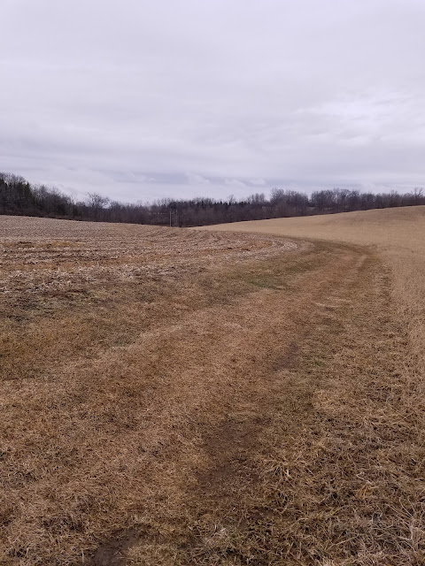
The Holy Hill Segment at the north has almost no hills at all. It runs in straight lines across or along fields, soldiering a path as efficiently as possible through the landscape.


But because of the wind, the rain and the cold, every hill felt just a little harder than it really was. 


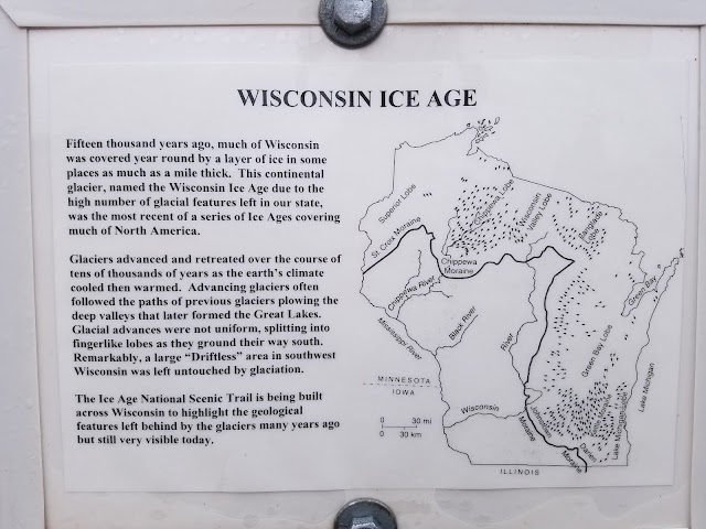
And there were even a few glacial features sprinkled about. We walked past one kettle that was so steep and so deep that the sun wasn't getting to the bottom, and there was still ice down there. 


This was the last stretch of heavy woods before we crossed East Waterford Road. After that we broke into open field again. 

And then we hit the great boardwalk of Holy Hill. Someone asked us if we had hiked past the boardwalk on Holy Hill yet. 

"We're not sure", we said. 

"Then you haven't", came the reply. 

Indeed, once you reach the boardwalk it is quite a marvelous structure, with full side rails on both sides. I'm not completely sure why there needed to be such an elaborate construction here, but for the three or four hundred feet of passage we felt very, very safe. 


Across the boardwalk we started up a small hill where the trail had been moved out of the trees, effectively shifting it about 15 to 20 feet to the west of its previous position. Again, I'm not sure why they moved it, but it made this rather unusual-looking tree much harder to miss. 

This tree has a story, and I wish I knew what it was.


To be honest, I don't remember a whole lot about the rest of the hike.  

There was one spot where we saw a flock of turkeys. I also remember that we had a turkey vulture that seemed to be following us as we walked. 

We were wet, cold, and trail-weary. Still - I think the buzzard was counting his snails before they, uh.. what do snails do? Hatch? I don't know. But we weren't buzzard bait just yet. UPDATE: Snails do hatch from eggs. Now you know.

We finished the Holy Hill Segment at 4:39 pm. It was 36 degrees, and it was still raining. This was not the most fun we had ever had, but we have long since reached the point where we take the trail as it comes to us. We also managed to finish map 84 in the process, so that was a bonus. Now - how far is it to Merton?


Before I get to the story of the Merton Segment, I have to describe what we had to go through retrieving our car at the north end of Holy Hill on County Road E. We were suspicious of the lot when we first saw it. Fields like this are notoriously slick in springtime, especially when it has been raining. 

When Theresa got into the car to drive out of there, the tires just spun in place. She couldn't get back up the small grade to reach the road. There was longer grass just a little further down the hill. I thought maybe if she just backed onto the firm ground with the long grass, maybe she could just make a run for it. 

This was not the solution. 

There is an expression that exploits the concept of the 'slippery slope'. We were living that concept, and we weren't winning the battle. 

I looked downhill. No good. The ditch was too severe and we couldn't get out that way. It was uphill or nothing. 

So we tried taking it in small bites, zig-zagging our way up the hill forward and back, trying to gain a few inches each time. No way, no how. We didn't even finish the first zig, let along get a zag in there. It was time for a radical solution. 

Faced with the likelihood of needing a tow truck to get us out of there, I took one more desperate shot. I turned the wheels downhill and started moving. The goal was to reach an untested piece of comparatively high ground with a lot of grass on it, then turn uphill with whatever speed I could muster and angle my way to the lowest part of the hill. 

For a miracle - it worked. 

I've been in a lot of bad places in vehicles over the years. I don't know that I have ever gotten myself out of a tougher spot than this one. I really didn't have much hope when I pointed the nose downhill and gunned it. Really - there was no real logic to it. I just figured I only had one chance to get some momentum going, and I lucked out. Maybe it was a different kind of Trail Angel helping us out. Either way, I was happy to be getting out of there on our own. 

Location 4The portion of the Merton Segment between the intersection of Dorn Road and Richter Road and the spot where the Bugline Trail meets Dorn Road
1.6 miles of trail covered

There is a certain craziness that comes into our decision making sometimes. I mean - we had already done a full segment Snail Hike, a short Connecting Route, and then driven up to finish off yet another segment. We had already walked 7.9 miles of trail. It was still drizzling and getting colder all the time. So why would we drive to yet another piece of trail and start hiking? Well - it was sort of on the way to the hotel, and... 

And I don't know what. It was madness. I guess it's because we managed to shoo the turkey vulture away and we were feeling full of ourselves. 

Anyway, we actually debated a bit and almost didn't do any more, but we spurred ourselves into it. We decided we'd do it as a crisscross hike to speed things up a bit. 

Theresa dropped me off at the intersection of Richter and Dorn and I started hiking west along the road. She drove to the bend in the road and parked, and started walking back. Twenty minutes later and we had the first four tenths of a mile done. 

I thought we would do the trail portion next, but we were starting to push darkness a little bit, and Theresa wisely wanted to get off Dorn Road before real dark happened. This made sense, so I dropped her off at the place on Dorn where the trail heads west on the Bugline, and I went and parked on Tamron Drive. We crossed in the middle and when she was done walking she came and picked me up. 

This left us in position for both of us to walk together along the seven tenths of a mile through the woods between those two short road hikes. 


This actually turned out to be a really pretty walk along the Bark River. I took this shot at about 6:30 pm. There wasn't as much light left in the sky as this photo might indicate. 


At times it was wooded, but mostly it was fairly open. 


 A lot of hard work has been done over time to keep the dogwoods, willows and alder from taking over the trail. 


Finally, we reached the parked car. It was 6:54 pm. We had only nine tenths of a mile left of the Merton Segment, but Theresa had reached a whole new level of 'done in'. 

Cold weather hiking takes a lot out of you, and today we managed to walk 9.8 miles clearing 9 miles of trail off the map. Silly as it might seem to those of you who have walked the Merton Segment, we were going to have to come back a fourth time to complete the whole 5.4 miles of it. 

In our defense, two of those hikes took place at night, with head lamps on, and today was done in near-freezing rain. Merton has been a chip-away segment from the beginning. No sense changing that now. 


Running Total: 976.9 miles of trail covered, 148.8 miles 'extra' hiking/biking. End of Day 146.

Sunday, March 13, 2022

 Day 145Holy Hill Segment (Part 1), Washington County

Day 145: Sunday, March 13th, 2022

Total Miles covered for the day: 4.0

LocationThe Holy Hill Segment, between the south trailhead parking area on Donegal Road and the place where the trail heads north from Pleasant Hill Road.
4.0 miles of trail covered

This was day two of our two-day weekend, and we had a short hike planned, followed by 'let's do as much as we can before we have to drive home'. 

The only real goal was to hike the terrible, hilly part of Holy Hill, between Shannon Road and Donegal Road. Anything after that was gravy. And - spoiler alert - it wasn't anywhere near as terrible as we thought it might be. 

Because we were uncertain how our van would behave, or even if we would HAVE a van to use for the weekend, we arranged to get a trail angel ride. This morning we planned to meet Sammy Ray Marshall at the Shannon Road parking area who would then shuttle us down to the parking area on Donegal Road. Sammy Ray, if you're reading this, you ROCK!

Our first challenge was that parking was terrible at Shannon Road. Four cars total, and all four slots were taken, even before we arrived. We had hoped to leave both vehicles there, but scuttled that notion and made other arrangements, putting in an extra tenth of a mile or two walking trying to figure it all out.  

Eventually, we ended up just giving Sammy Ray a patch and a gas card and thanking her immensely for coming out to give us a ride. Then we shuttled ourselves down to Donegal Road where we met the rest of the people who made up the Snail Hike. 

Yesterday was brutally cold, and only one person showed up all day. Today promised to be a much nicer day, and we had a total of three hikers show up to walk with us, two of whom were new snails. 

Meet Mary Siekmann and Jane Flatt. 'Jane from Janesville' she called herself. Mary was just 'Mary'. Both were delightful hiking companions. 


We were also joined by a hiker we met earlier, Billie Burdick, who appears in several of the following photos. 


After a short hike eastward down the road we were at the trailhead. We started walking at 11:00 sharp, and the temperature was a warm, sunny 31 degrees. The cranes were sounding off in the marsh, trumpeting as we went on our way. 


Just as we started one of the women realized she had forgotten to lock her car. She went back while the other two waited. Theresa and I pressed on up the hill, but we left behind the mark of the snail, just so they knew which way to go. 


The trail from the south starts out with the biggest hill of the hike. If you include the parking area, the climb is from 1030 feet in elevation to 1222 feet. Even so, the 200 foot climb seemed oddly easy, or else it was just the perfect combination of early, cool, and well-rested. 


Or maybe it was the ice cleats. 


We first spotted The Basilica and National Shrine of Mary Help of Christians as we crested the first big hill. That's a mouthful, but then so is the name of the group that cares for the facility, the Discalced Carmelite Friars of Holy Hill.


We took a short break at the top of the hill, but didn't sit on the snow-covered bench. Our group was still a little behind us, but shortly afterwards we were overtaken by the Shields family. 


And Jynx, their dog. 


There were times when the tread got a little challenging, even with the cleats.


At the top of the second hill was when we got our best view of the segment namesake. There was a bench here, too, also snow-covered. 


There would be more hills, but when we left this one, we had conquered the worst that the Holy Hill Segment would throw at us. The grin on Theresa's face was partially because she knew that fact. Our group had caught up to us by now, and we were happily strolling along, chatting and having a merry old time. 

As we got close to the Stationway parking area we heard the familiar cry of "Snails!" Chelsea Harris and Carol Wilson were really happy to see us and claim their prize. 


Here, too, was a nice parking area with a great view of the basilica. There's also a stone archway visible with a person standing under the arch for scale. 


Sadly, the restrooms weren't open, so the ladies had to make their choices and take their chances. For me, it was less of an issue. 

Just after crossing Station Way Road we encountered another familiar hiker, who was unable to join us at the start. It was Mary Schwab and her brother Paul Schwab. Mary got her patch last year, but Paul got his today. 


They were hiking the opposite direction, and after a brief chat, we all went on our way. 


It was a nice trail, and had leveled out quite a bit as we wandered through the woods. There were also a number of interpretive signs, introducing people to some of the familiar trees that are essential parts of the 'Northern Mixed Hardwood Forest'. 


We had reached a point on the trail that the rest of the group could no longer meander along at our Snail's Pace. Poor Mary had parked all the way at the north end of the Segment, while the other two were parked back at the start. She also had some dogs at home who couldn't be left indefinitely, so they picked up the pace and headed north while we kept plodding along. 

We stayed in touch with the group by text message, and we know that they all found their way safely back to their cars. We made it to Shannon Road with no issues, and I hiked the extra tenth of a mile down to the parked car. 

We had to drive back down to Donegal before we could do anything else, and we ended up spending quite a bit of time setting up for the next leg. 

This iconic hill is a typical kame, of which there are many throughout the Kettle Moraine area. 


We set up the cars for a very short hike, going from the east end of Pleasant Hill Road to Shannon Road, which meant starting with a short road hike. Right as we were about to start walking, my phone rang. It was work. Another emergency call. I told Theresa to hike on ahead of me, and I would catch up if I could.

After fifteen minutes or so on the phone, I determined I could walk and talk, so I took off at a trot to catch up with her. 


The going was straight and easy, and we were walking into the face of the late afternoon sun. 


I did catch her eventually, and we finished together. We ended this leg at 4:00, and I was just getting off the phone. It was 48 degrees. Somewhere along the way we encountered two more snails, Ann Feiler and Carol Bredesen, but sadly my phone pulled its 'vanishing pictures' trick and I lost the photo. 

It was Sunday, and it was 'go home' day, so even though the next leg was only a mile long, we knew we couldn't finish the rest of the Segment, so what was the point? Instead we left behind the last 2.9 miles for another day and called it quits while we were both still standing. 


Maybe 'leaning' is a better term. 

Running Total: 967.9 miles of trail covered, 148.0 miles 'extra' hiking/biking. End of Day 145.

Saturday, March 12, 2022

Day 144Pike Lake Segment, Slinger Segment, Cedar Lakes Segment, Washington County

Day 144: Saturday, March 12th, 2022

Total Miles covered for the day: 7.8

Location 1The Pike Lake Segment
3.3 miles of trail covered

We drove down last night and stopped by Oshkosh to pick up our van. It had conked out on us on our last trip to the region two weeks ago, and we got it back for the sweet sum of about six thousand dollars. Given the alternatives, six grand didn't seem so bad. New vans are running sixty grand. I'd call the repair job a bargain. 

We had actually come down on Thursday night to get it, but discovered within a few miles of leaving the dealership that there was still something wrong with it. Oh well. One more day at the shop, and it was running good as new. 

Unfortunately, we didn't get to the hotel until 8:30 pm, so there was no time to do any late-night connecting route hiking. Instead, we set our sights on getting up early to make our connections for the day. Not being 100% sure that we would have two vehicles, Theresa arranged for some trail-angel help, and we decided to go ahead and make use of that because we were still on shaky terms with the refurbished van and it would enable us to give away a couple more SnOTT patches. 

Since we had set our goal on hiking all of Pike Lake, Slinger and Cedar Lakes, we dropped off one car at the north end of the Cedar Lakes Segment, where we planned to end the day. Then we drove to the Community Drive parking area in Slinger where we were planning to meet our first angel. 

We arrived at 9:00 am sharp, and our angel Stacy Schickert was waiting for us. Stacy had recently received one of our SnOTT patches, and was giddy to be able to give us a ride. While we were there, another vehicle pulled up and Jason Solberg eagerly popped out to ask if we were the Snails. 

"We are," I told him. 

The result, of course, was the awarding of a SnOTT patch. The day was off to a great start. This is Jason Solberg and his trusty golden retriever, Biscuit. 

Jason was thrilled. Biscuit was unimpressed.


Stacy proceeded to shuttle us down to our intended starting location, at the south end of the Pike Lake Segment, at the intersection of County Road E and Glassgo Drive. 

Not too surprisingly, no one was there. There were a couple of reasons. The first was that we had made a tiny error in the group hike instructions for the day, telling people to meet at the Donegal Road parking area. That would have been fine if we were hiking Holy Hill, but since we were hiking Pike Lake that was a bit of a problem. Everything else was there - the itinerary, the direction of travel - but all people saw was 'Donegal' and anyone who would have met us today ended up going on a group hike somewhat south of here and without us. 

The second reason no one was with us was that it was bloody cold outside, and the wind was blowing fiercely from the west. With a starting temperature of seven degrees and a steady 20 mph wind, the wind chill was 15 to 20 degrees below. We have done plenty of cold-weather hiking. This was our coldest hike yet. I checked the charts. Theoretically, temperatures this low will create frostbite on skin exposed for more than 45 minutes. 

So alone, we started hiking at 9:38 am with blue skies and gusty winds. I took a few finger-numbing selfies and promptly layered back up for the hike. 


The segment starts out with a descent down a series of steps, including this long stone staircase. Right away we could see there weren't enough blazes on the segment. 


When we got to the end of this first piece of trail, it dumped out onto Glassgo Drive, without much fanfare or indication of which way to go. I remembered from studying enlarged maps earlier that we had to turn left, so we did. 

The 'trail' walks along Glassgo Drive for a while, with a nice open view of a park and waterway to the west. A view is all we got, though. Apparently hikers are personae non grata in their Private Park, and they have the signs up to keep it that way. Notice the nice shelter building and picnic tables in the background. 


Not exactly a Trail Community. Their reception was colder than that west wind coming off the pond.

When we reached the north end of the road we had no trouble identifying which way to go. But that quickly turned into ??? when we reached the first trail intersection. We were warned that the blazes were a little sparse and confusing going through Pike Lake State Park. With nearly 1000 miles under our belt I thought we were ready for anything, but this route was a new experience entirely. 

Taking the path that seemed the most traveled (there were thousands of footprints in the snow, going every which way), we eventually found a trail marker about a quarter of a mile later. 

The yellow 'blazes' were definitely not what we were used to. 


It was our first indication of what was to come. 

As we walked, we were perpetually blasted by the wind roaring in off Pike Lake. It kept us moving, and it kept my gloves on. I didn't take any pictures through here. Fairly soon, thought, we reached the large parking area on Kettle Moraine Road. From here, the trail markings just got worse. 

If you know the code, you can succeed, but it's different through here. 4x4 posts have multiple colored bands, are placed at trail intersections, and sometimes have no directional arrows at all. 


There was lots of parking here, and I believe the restrooms were open, though we didn't check. 

When the trail leaves the parking lot, there is a nice bench followed by a significant uphill climb. We reached one corner and I had to take a side trip of about a tenth of a mile just to figure out I was not on the trail. Nice view at top, though. 

I backtracked and finally figured out the system. If there is an arrow at a sign, it means that ALL the trails go that way. Forget about the other three trails you see - those aren't REAL trails. Follow the little arrow on the sign for the observation tower, silly!!

Along the way we encountered several nice benches and a few other places to sit, like rocks and logs. We also saw a number of other people out hiking or walking their dogs, but none of them ended up getting patches. 

We opted not to take the side-hike to go up to the observation tower. I'll probably go back there some day, because this is the site of Wisconsin's oldest geocache, but today we were trying to make miles, and it was too cold and too far off track. 

The hills were hilly, but not too terrible. When we made out way down to Powder Hill Road we confirmed that there is absolutely no parking there, but there is a large parking lot just a tenth of a mile or so down the trail. 

Across the road, the trail became more broad and open again. After we brushed past the large IAT parking lot the going was more level. 


On the north side of the trail there are three large backpacking campsites, each with picnic tables and fire rings. These are not IAT DCA Sites, and I'm not sure what the rules are for using them, but they looked like awesome places to spend the night. 


Past the campsites, the Pike Lake Segment ends as a long flat area through a nice cedar grove. Lots of birds, including cardinals, woodpeckers, juncos, chickadees, and others. It was nice to see some birds in the woods. 

We came out onto the road (County Trunk CC) and walked north for 0.27 miles. We had briefly been out of the wind for a while, but now we were back exposed on the roadway. 

Reaching the end of the Segment, we had a tough time crossing a very busy Highway 60. We ended the Segment at 12:40, and the temperature was up to 13 degrees. It actually felt warmer, but it was still windy and cold. 

Location 2The Slinger Segment
2.1 miles of trail covered

We started our Slinger hike at 12:50, after a brief snack. The sun was shining, and it was 13 degrees. Wind chill was more like seven below now. Much better! No wonder our faces didn't freeze!


The south end of the Slinger Segment is a short, straight, level hike along the edge of a farm field. Think bike path. This brought us to the edge of town, where we found this sign just before hitting the city streets. We took off our spikes and walked the rest of the way on roads. 


The blazes were excellent in the Slinger streets,. At least they were once we made our way to Hartford Road. When we first left the trail behind us it was a bit ambiguous which way to go. 

Walking through Slinger was entertaining, except that we were too cold to really enjoy it. As I walked past one historical building after another, I kept thinking I should take a picture or two, but never pulled out the phone. 

Our car had been left in Slinger at the Community Drive parking area. We got there and checked the phones. Nope. No one planning to join us late. Still hiking by ourselves. 

Chuck it, we thought. Let's get lunch. 

So we turned around and went to the Slinger Inn for a fine meal, getting ourselves all warm and comfy... almost a mistake. Warm and comfy, with a car close at hand... Do we really want to go back out in that cold wind and keep hiking?


There was never really any doubt. We wanted to finish these segments today. 

Just as we were getting ready to leave and hike the next stretch alone, we got a ping from Angela Rabbitt. She was following our progress during the day and figured out she had just enough time to catch up with us for the rest of Slinger and Cedar Lakes.


We took the time to shuttle Angie's car to the other end of the Cedar Lakes Segment, figuring she could take off at any time and walk to her car if she needed to get going. She never did, but it was good to have that option available. 

The hike from the Community Drive parking lot is literally a walk in the park. Thanks to the paved walking path...


... and the amazing new boardwalk.


We didn't need our ice cleats at all. We finished Slinger at 3:30 pm, temperature now all the way up to 17 degrees. 


Location 3The Cedar Lakes Segment
2.4 miles of trail covered

The Cedar Lakes Segment now extends down the road to meet up with the Slinger Segment, which I forgot to mention now takes a different path through the north end of town than it used to. That means there is no longer a connecting route between these two segments. 

We started out with the road walk, a 0.4 mile hike to the east, which kept the wind at our backs for a change. 

Then we headed north into the hills again, into a region known as the Polk Kames. 


A kame cluster is basically a bunch of kames in a small area. In this case, the topography looks like the bottom of a cat's paw, with five obvious kames all grouped together. The IATA chose not to hike us to the top of any of them, which was a relief, but the trail was still pretty icy, so we were glad to have our ice cleats with us. 

Past the kames, the path became more open again. Thankfully the wind had died down a bit as we took this leg to the west. 


I remember looking south on this field and seeing the road just a short distance away, thinking, 'I could have just hiked up here along the field and saved myself the trouble of hiking up into the hills'. But then I would have missed the kame cluster. 

You know what - they're hills. At this point the kames and eskers and drumlins are all starting to look alike. 

Coming back into the woods again I was happy to see this sign, which I missed photographing during our hike at Southern Kewaskum. We owe a lot to these guys. 


We ended our Cedar Lakes adventure at 5:02 pm. One thing stuck out at me. I didn't see any cedars, and I didn't see any lakes. A few hills, maybe, but the lakes for which the segment was named weren't even visible from here. I wouldn't catch sight of them until we hiked the connecting route to the north. 

Our van was waiting for us, and it was a welcome sight. Angie's car was waiting for her too, so we were on our own. We were also very done for the day. We hiked three segments today, and it felt like it. I don't care that they were short segments, hiking in bitter cold temperatures takes a lot out of you. 

I would like to have said we completed some sort of milestone after this, but we didn't. We didn't finish any maps, or any counties. I can't even say we finished all the Segments in Washington County. But I will gladly say to anyone still reading that we finished THREE SEGMENTS TODAY, and that is worth celebrating anytime. 


Running Total: 963.9 miles of trail covered, 147.7 miles 'extra' hiking/biking. End of Day 144.