Sunday, February 20, 2022

Day 140: Parnell Segment (Part 4), Sheboygan and Fond du Lac Counties

Day 140: Sunday, February 20th, 2022

Total Miles covered for the day: 3.3

Location: The Parnell Segment, between the road crossing on County Road SS and the road crossing on County Road F
3.3 miles of trail covered

For three days, we have worked on the Parnell Segment. On all three days we stopped before the end of day, for one reason or another. The first time we stopped because the roads were too icy to get to our next intended parking area and nearly ditched the van trying. The second time we stopped because the hills were taking too much of a toll. The third day we stopped because there wasn't quite enough time in the day to hike the last 3.3 mile stretch. 

To be fully honest with ourselves - we've been avoiding this 3.3 mile stretch because it's been bitter cold and windy, and we didn't feel like walking that far all at once. 

So now, this one section, which could have been broken in half if not for the ice-covered roads, is all we had left. And I'm not talking about 'icy' roads. I'm talking about roads that are covered, top to bottom and end to end, with a one inch layer of ice. Glassy and slick on the top with a dynamic friction coefficient of about 0.05. In other words - don't go there. 

So we had no choice but to do the whole hike in one leg. This might have been better if we had tackled it earlier, when the ground was good and frozen, but the temperatures today were going to get unseasonably warm, and we were facing mush and even a little mud for our walk. 

We weren't looking forward to it. 

So on our way through the town of Dundee we stopped at the 3 Sweets Bakery and Café to get some motivation. I stopped because I knew Theresa wanted to stop there. She had told me as much the day before. Theresa stopped because she was going to stop whether I did or not. 

It's an interesting little shop, and it does a whale of a business on Sunday mornings. When I arrived the 'Closed' sign was still hanging in the window. That didn't stop the locals, who knew full well the place was open, and they were packing the tables when we walked in. 

We browsed. They had some sweets, which Theresa bought, some handmade soaps and lotions, which she didn't buy, and a variety of bric a brac to go along with the regular breakfast menu. We didn't stay for breakfast, and it wasn't even really about the sweets. It was about wanting to stop and smell all the wonderful small town bakery goodness that fills places like this. It was a nice place, with nice people. Next time we go through we're going to sit a spell. 

Another feature in Dundee which I would have liked to admire more closely was the old mill, built over the East Branch Milwaukee River south of Long Lake in 1856. The water wheel was frozen in place, but the mill was a fascinating spectacle. 

With nothing left but the hiking, we dropped a car at the north end of our intended hike on County Road F, where there was just enough melting that we could safely park right next to the trail this time, rather then driving a tenth of a mile down the road. Then we drove to the SS Parking area and headed for the trail. 

We started hiking at 11:05 am, and the temperature was already up to 39 degrees. By the time we finished hiking at 2:20 pm the temperature would hit 51. 

This was the last hike on the Parnell Segment for us. Our goal may not seem ambitious to others, but covering 13.9 miles of hills in the snow, wind and ice, all in one long weekend, was good enough for us. 

The skies were blue and sunny, and there were steady 20 mph winds from the SSW. 


The hike starts out in Sheboygan county, but quickly crosses over into Fond Du Lac County. The boundaries aren't marked. 
 

At the very beginning there were a couple of steep hills to climb, but then there was a long section where we walked almost on the level as we made our way around Crooked Lake. There was certainly opportunity to the west to have taken us up and onto some large and imposing hills, but I'm really glad they didn't. We were really more in the mood to just mosey along and climb as few hills as possible.

We were overtaken on the north end of Crooked Lake by a solo hiker and his dog, a curly-haired black lab mix that he referred to as a 'Chessador'. Obviously, that's a cross between a Chesapeake Bay and a Labrador. It was a pretty enough animal, but I don't know about all these fancy new crossbreed 'breeds'. Labradoodles, Schnoodles, Buggs (Boston Terrier/Pug) and others are cute in their own way, but let's just admit that a lot of these so-called new breeds of dogs started out as - ahem - an open gate in the yard?

Anyway, the fellow was nice enough, and the dog was very friendly. I find that almost all dogs are friendly if you give them a chance. Off he went at his pace, and we at ours. 

This was right before a little hill we had to climb, and at the top we stopped to sit on a log. We weren't so much tired as hot and overdressed. 

I made a tiny, little snowman. 😀


Immediately on the other side of that hill we crossed Division Road, There is enough room there for one vehicle, if you can get there. As we crossed, sure enough, one vehicle came driving by from the east. There was a bit of fresh snow, and the temperature was above freezing. Maybe there was enough traction on that ice runway for him to get safely through. We never found out. 


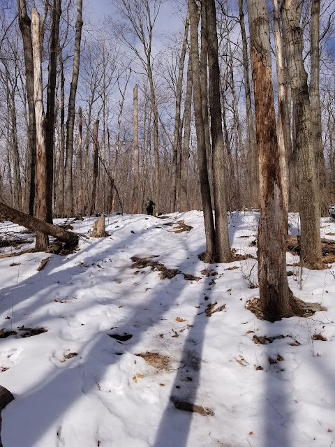
Crossing Division Road got us back into Sheboygan County again. Right away, the path got hillier, and the trail conditions worsened. The worst part about it was the route, because the trail went straight up one hill and straight down the other side, without utilizing switchbacks. This is terrible in most places, but on this glacial till it's just plain old mismanagement. The erosion was evident even under the ice, and as the streams were running down the trail from the rapidly melting snow, it was getting nothing but worse. Even some of the potato rocks were coming loose, making for the kind of hiking we were trying to avoid.


The vast majority of birds' nests are good for only a single season and are not reused. Even knowing this, I still felt the urge to pick this old nest up off the ground and find the crook of the tree it came from so I could put it back. It looked lonely there. 


One of the lakes visible from the trail.


One of the hills visible from the trail. 


By this point many of the ice patches had turned to slush, and the mud was starting to form on the edges. As we walked we discovered a limitation of the ice cleats. We could walk with confidence over solid, slick ice, but turn that ice into sticky snow and mush, and it starts forming ice balls on the soles of your boots. 


We finally crossed paths with several groups of hikers as we made our way north of the three Kellings Lakes. The first two were women, who were real trail runners. Literally, they were running along, holding an animated conversation as they ran. They weren't even winded. 

I was never in that kind of shape. 

Then we crossed paths with an older couple who were the first people we've met on the trail who could give us a run for the title of Snail. 

Then we met a man and his son out exercising a 9-year-old pointer, who was all business and had no interesting in talking to us. The dog, that is. He was busy working. The dad and son chatted a while. 

All of this happened in a stretch of about two tenths of a mile just before hitting the intersection with the blue spur trail. (0.7 miles). 


We had the last six tenths of a mile to ourselves. I'm glad, really. We needed some time alone. Or I did, at least. 

For a while, I just hung out far behind Theresa and watched her walking down the trail in front of me. As we neared the end of the Parnell Segment I started thinking about the end of the trail. It wouldn't be all that far ahead of us. By the time we finished today we had only about 275 miles left to go. 

Even the longest journey can feel shorter when you start getting close to the end. Today, with nice, warm temperatures and the happiness of achieving our goals, Theresa was in a pretty good mood, and her pace was showing it. 

Life is that same, long journey. We have a ways to go yet, but we're getting to the point when the end of our trail isn't 'out there' somewhere. It's getting closer, and it's getting real. Someday, and it will come sooner than either one of us wants, we won't be able to go hiking together on thousand-mile odysseys. And then someday, one of us will be hiking alone. 

I don't typically borrow the future, but today I was thinking what it would be like if I'm the one left walking through life alone. It made me a little melancholy, and I thought to myself as I watched Theresa walking confidently ahead of me that this day, this image, this person, is the one I want to remember if that terrible day ever comes. 


Running Total: 937.1 miles of trail covered, 147.5 miles 'extra' hiking/biking. End of Day 140.

Saturday, February 19, 2022

Day 139: Parnell Segment (Part 3), Sheboygan County, 

Kewaskum Segment, Washington County

Day 139: Saturday, February 19th, 2022

Total Miles covered for the day: 4.8

Location 1: The Parnell Segment, between the road crossing on County Road V and the road crossing on Kettle Moraine Scenic Drive
1.3 miles of trail covered

Today was supposed to be a group hike for the 'Get Off The Couch' hiking group, known affectionately as GOTC. Unfortunately, due to the brief but ferocious winter storm that was unleashed on the region last night, that hike was canceled. This actually worked in our favor, because we fell 1.3 miles short of our loosely-defined goals yesterday, and had a small section to hike north of where the group would have been hiking. 

Of course, we didn't know this until after we had gotten up and started getting ready, so we were uncharacteristically early in being ready for the road. 

We were able to double-check our parking places and get our vehicles in position by 10:00, and we were actually at the start of the trail by 10:13 am. 


The sun was shining, but that did little to offset the brutal cold and west winds. It was only six degrees, and the winds were blasting from the west between 10 and 15 miles an hour. This by itself wouldn't have been too bad, except we weren't hiking in the woods, we were hiking on top of the famous Parnell Esker. 


It was interesting, standing on top of this esker and looking down to the west to see a huge lake that showed up neither on the trail maps nor on Google. I could find no name for this wetland region that was a quarter mile wide and a half-mile long. 


As I was walking, I came to the conclusion that if 100 different people had been given the task of choosing a hiking path through this area, all 100 of them would have independently selected the exact same path. There is one, and only one way to get through here, and it is atop the Parnell Esker. Rising steeply from the surrounding wetland, the esker stands roughly 50 feet above everything else around it. 

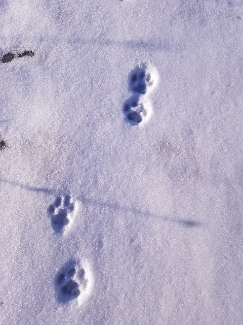
We were the first people to lay tracks since last night's snowfall, but we weren't the first ones there. As we walked, we saw the tracks of what appeared to be a coyote, who led the way in front of us for nearly a mile.


We also saw tracks from rabbits, squirrels, and mice. Which is probably why we saw the coyote tracks. 

Theresa, who is normally very warm as we hike, was bundled snug and deep as we walked on top of the hill, exposed to that bitter cold west wind.


Eventually the trail did drop off the north end of the Esker, across a small wet area that had a boardwalk, and up the other side onto another hill. Between the logging and the storm damage, the skyline looked a little ragged. 


We crossed a snowmobile trail roughly one hill from the end, and found our way to the road. The car was waiting at the pull-out a tenth of a mile to the east, and we got there at 11:30 am. The temperature had climbed to 10 degrees. 

Location 2: The Parnell Segment, between the road crossing on County Road F and the Butler Lake parking area 
1.4 miles of trail covered

The next leg required that we reposition the target vehicle again at the Butler Lake parking area and drive to the road crossing on County Road F. We found that about a tenth of a mile west of the crossing, there was ample room to pull a car or three off the road, and we parked our launch vehicle behind a truck, whose occupants were also out enjoying the trail. We could tell because of the footprints. 

We were underway by noon. It was still only 10 degrees out, and the wind wasn't getting any softer. At some point in the past, someone had placed two gallon jugs of water at the intersection. They remain there, a frozen testament to a gesture I wouldn't ever take advantage of, or preparations from a previous hike that were left behind as trail litter. 


This leg was very much like the previous one, except it wasn't as steep, or at least, not at first. There was an initial hill to climb.


As with other areas in the Kettle Moraine region, we found good general signage. I'm no longer surprised to see absolutely no blazes on the trees. Literally every blaze was on a 4x4 post that had to be dug into the ground through all those stones and rubble. 


There is a Cold Cache here on this segment, describing some of the land features as crevice hills. 

There was quite a bit of logging in this area, but it didn't have as much of a visual impact as some of what we hiked through earlier. The early going was mostly level. This wouldn't last for the entire hike. Toward the north end, we started running into real hills, climbing up, down, and up again to stay on top of the eskers. 


We were not the first humans on this section of trail. We started out following the out-and-back tracks from the aforementioned truck owner. Just about the time that those stopped, we encountered another set of tracks coming in and back from the other side, but those were from a different hiker. Then we encountered a third set, also coming in from the north end, and also showing evidence of just a short walk. None of them appeared to be dedicated Ice Age Trailers, but then, how would we know?


On top of the very last hill, still part of the Parnell Esker, we got a great view of Butler Lake and got to enjoy one of the rare benches. It was cold and windy, and we were only 500 feet from the van. We didn't stay long. 


Back at the car by 1:20 pm. I don't know what the temperature was. I'll just say cold. That will cover it for the whole weekend. 

Over the course of three weather-restricted days we had managed to cover 10.6 miles of the Parnell Segment. This left us with only 3.3 miles remaining, which if you look at the map only tallies to 3.2 miles. Either way, it was too far for our current energy level. We needed to get out of these hills. 

South of the Milwaukee River Segments, on the way to West Bend, there was the Kewaskum Segment, a mere 2.1 miles. Theresa and I decided we could probably handle that much, so we picked up the other car and headed south. 

Location 3: The Kewaskum Segment
2.1 miles of trail covered

Did I say we were trying to get out of the hills? This certainly wasn't the way to do it. In fact, from the driving we've been doing and the hills we've been seeing, I don't think there is anywhere you can go out here to get away from the hills. Even the roads are hills. 

We scoped out the segment and as we approached the central parking area we found... a ski hill. The Sunburst Ski Area was bustling with cars and people, all wanting a piece of this sunny Saturday afternoon. 

Our initial impression was that it would not be possible to park at the east end of the segment, where it goes under the highway and runs directly into the southern twin of the Milwaukee River Segments. It turns out we were wrong - a car could have been parked there at the beginning, but we didn't realize it until we had already gotten underway with a crisscross hike. 

Theresa dropped me off on County Road H, one tenth of a mile north of the trail. I got to the trail by walking down a nice, gravel bike path. This led to the tunnel that goes underneath the highway and up the other side into a marsh. The water table through here is high enough that there is a sign warning hikers not to cross through if it's flooded. 

The goal was to clip off 0.6 miles and leave ourselves with a hike between parking lots. I started at 2:40.  


On the other side, I found myself walking through a level, grassy marsh area. There were plenty of boardwalks through this section. I can only assume it gets wet in the spring. 


And this is where I crossed paths with Theresa in the middle.


When I got to the car at the ski hill, I was getting odd stares from the other people in the lot. Everyone else had ski poles. I had a stick. The distance along the road, between the ski hill parking area and the east-bound trail, is barely two tenths of a mile, though the sign says 0.3. I didn't care. Shorter was better. 

I drove back to pick Theresa up at the end by the bike trail. 

"You could have parked right there at the end and picked me up," she told me.

"Really?" 

"Yes - there was a place you could have pulled in straight off the highway."

She was right, and I had walked right by it without even looking up. Next time we come back to do the Milwaukee Segment, I'll remember that little trick. 

Next, we drove up to the top of the hill and the south/west end of the Kewaskum Segment. It was 3:31 pm. We didn't choose this direction on purpose, but we sure did luck out with the hiking. The trail started out there at 1120 feet in elevation. It went up another 20 feet over the course of the hike, but then plunged down to just under 1000 feet in elevation. Going the other way, that 120 foot climb might have been a bridge too far for Theresa. 


This time, along with the fox and coyote tracks, we also saw a kitty-cat. 


We got a phenomenal view of the surrounding area and the distant drumlins at the first bench we encountered. 


The way remained fairly gentle, some downhill followed by some uphill, for quite a while. I stopped to check out the DCA, and it was adequate. Nothing to write home about - not even a view. And - there was a no-fire restriction. 


We came out into the open, walking through a farm field of some kind. We strolled along the top of this hill for nearly three tenths of a mile before finally coming in sight of the ski hill. There was a second bench along the way, but we didn't stay long because it was still windy and cold. 


When we reached the ski hill, the whole trail changed character. It got quite a bit steeper, but we were (luckily) going downhill so it wasn't slowing us down. 

Unfortunately, the closer we got to the ski hill itself, the worse the trail got. At one point we were suddenly faced with an eight foot section that dropped at a 45 degree angle. It was the first time I started sliding despite the ice cleats. Fortunately it was short, but then there was another obstacle. There was an orange fence that had been strung across the trail blocking the way. It was partly laying on the ground and didn't belong there, so we stepped over it and clawed the rest of the way back down to the bridge and the parking lot. 

This last tenth of a mile ruined what was otherwise a very enjoyable hike. We finished at 4:45 pm. The temperature got up to 14 at some point today, but it never felt that warm. There would be no restaurant tonight. We learned that lesson yesterday. 

Running Total: 933.8 miles of trail covered, 147.3 miles 'extra' hiking/biking. End of Day 139.
 

Friday, February 18, 2022

Day 138: Parnell Segment (Part 2), Sheboygan County

Day 138: Friday, February 18th, 2022

Total Miles covered for the day: 5.1

Location 1: The Parnell Segment, between the north trailhead and the road crossing on Scenic Drive
4.4 miles of trail covered

We spent last night at the AmericInn in West Bend, which was a tenth of a mile from the trail in West Bend, but a 45 minute drive from the north end of the Parnell Segment. Our entire focus this weekend was to hike Parnell, a total of 13.9 miles, and we had four days to do it in. Yesterday, though, was a driving day, and due to our late start and hazardous driving conditions we only managed to snip off a little less than three miles. 

The wind had totally changed directions, and would be blowing south to north, so we changed tactics and went to the north end first. We were working our way south by walking south to north in bite-sized chunks. 

To get underway, we left a vehicle at the ice-covered parking area on Hwy 67 at the north trailhead, then drove to the crossing with County Road U to see how close to the trail we could park. At worst it would be a half-mile away, but it turns out there was just barely enough room on the shoulder to leave a car at the trail crossing. 


We started walking north at 11:15 am, with the temperature the same as yesterday - 20 degrees. Unlike yesterday, though, the wind today would definitely be a factor. The forecast called for winds from the south at 20-40 miles an hour, and I believe from the sounds the trees were making that we spent all day in that range. 

It was a bright, sunny morning. I noticed that every time I looked up at the groaning branches, wondering if one of those trees would come down on our heads. 


The trail was immediately hilly, starting with an uphill climb on hard-packed snow and ice. 


The climb was fairly steady for about a half mile, until we encountered the side-trail that led to the Parnell Tower and the official parking area. At the top of this hill we took our first real look-around, and what we saw was hills in every direction. It was an omen that would define the rest of the day.


Immediately to the north of this intersection was Shelter #4. The shelter was great, and there was a nearby outhouse for those who need it while hiking. Even better, we saw a bench, which I think is the first one I have seen along the trail in the entire Kettle Moraine area to date. We have not made use of any of these shelters in the Kettle Moraine, nor are we likely to anytime soon. But they would be a highlight stay for those who are through-hiking, as they provide cover, seating, and campfire rings. Someday I'd really like to go back and spend a night in one of those. That would be roughing it in style. 

Or maybe not.

In the book Woodcraft by George W. Sears, he says, “We do not go to the green woods and crystal waters to rough it, we go to smooth it. We get it rough enough at home.” 

Well said, George. Staying in one of these shelters would definitely be 'smoothing it'. 

The trail goes back downhill pretty rapidly from the shelter in either direction. Headed north, I found the trail to be quite steep and icy, but with the ice cleats we were having no problems. 

The trail had a tendency to stay on the ridgebacks of eskers wherever it could, but there was ample opportunity to claw our way up the side of one hill and back down the other, or dip into a kettle or two. 


At a few places along the trail there was signage, showing where we were in relation to the myriad crisscrossing trails that went through for horses, bicycles and people. 


As far as yellow blazes go, there was an overall lack of them. There were enough that you were unlikely to get lost, but there must be some sort of restriction against paint on trees in the Kettle Moraine area, because all the yellow blazes were on 4x4 posts. 


After cresting one hill, we heard the roar of an approaching wind gust. It boiled through the trees, thrusting them violently in our direction, sustaining a ferocious blast that was easily 40 miles an hour. From that moment on I made it a point to look up and see what we were walking under. Today was a day that some of those widow-makers would be falling. 

A little after 12:30 we found a nice log to sit on for a break and a snack. Shortly afterwards we crossed paths with a lone hiker, the only other person we would see on the trail today. 


When the trail crosses from the Town of Mitchell to the Town of Greenbush, it takes a sudden turn left (for us) and briefly goes down a hill in a straight line, running parallel to a horse trail. We were quite surprised to see two fat-tired bicycles cruising along this trail on top of the ice. I didn't look closely, but Theresa said they must have been e-bikes, because they were moving uphill and not pedaling. 

Then the trail takes another turn north. This was the one place where I saw a tree that was actually laying in the way of the trail. For the most part, anything across the trail had been diligently removed by chainsaw, and some of that was quite recent. I stayed with my saw long enough to clear most of it out of the way while Theresa walked ahead. 

By the time I caught up to her she was walking through a lovely stand of balsam fir trees, some of which were very large and very old indeed. It was relatively level hiking, and was absolutely the most inviting part of the Parnell Segment we've seen so far. 


This ended up being very close to the north end of the segment, which we reached at 1:45 pm. The temperature was up to 25 degrees. 2.6 miles completed so far.

We had a tiny bit of a challenge getting out of the parking lot, but were soon on our way to starting the next leg.

We drove down to Scenic Drive, wondering if we would be able to park anywhere close to the trail crossing. As it turned out, a tenth of a mile to the east there is a decent turn-out, so we parked there and headed north. 

The wind was still blowing steadily, 15-30 miles per hour. It was 2:08 when we started, and down in this area there had been significant thinning, a logging practice that removes many of the mature trees but leaves a sprinkling of stems to provide optimal cover for developing seedlings. The result was that we lost all of our windbreak protection, and the gusts of wind were blasting us from behind as we walked up and down the snow-covered trail. 

Not a lot of actual ice through this area. Mostly it was just just crusty snow. But this 1.8 mile section had an entirely different feel to it. With so many of the trees gone, it was possible to see long distances through the trees and get a feel for the awesome bigness of the area. 

Between the howling wind and the massive rolling hills and moraines, I got a mental impression of a small boat being tossed about on massive waves in the open ocean, except that these hills weren't moving. 


The benefit of hiking in the winter is that the loose rocks and stones in this region are frozen to the ground. Here is an upended tree showing just what kind of glacial till makes up the soil in this area. 


As we were walking atop one of the eskers, we hears a sound that was so musical in character that both of us reached for our cell phones. It turned out to be a tree, blowing in the wind, and making an unusual two-tone sound.

And of course, there are always mushrooms, even in this weather. Here is a cluster of small puffball mushrooms, still holding  large number of spores. 


This section felt like it would never end. Every time we thought we saw the end coming, there was always another hill, another valley, another ice-covered crossing. 
We finally got to the car at 3:40 pm. In theory, it was 30 degrees out. In practice, it felt like 10. 


Location 2: The Parnell Segment, between the Butler Lake parking area and the road crossing on County Road V
0.7 miles of trail covered

The next leg to the south below where we had just hiked would have been 1.3 miles, down to County Road V, where there was adequate parking available. Theresa was feeling too tired to make the journey, and the cold wind was taking a lot out of both of us. 

But we didn't want to totally waste the rest of the day. I managed to talk her into hiking the relatively flat 0.7 mile section that runs between the Butler Lake parking area and the County V crossing. Though there was adequate parking on both ends, we decided to do this as a crisscross hike. Theresa started at the parking lot and I drove the car up to V to walk back. 

I said it was relatively flat. That would be relative to what we had been hiking in. In actuality, the trail goes immediately up and over the end of the Parnell Esker, which rises a good 25 feet or so from the parking area, up a set of about 30 log steps. 

The wind kept blowing, and on the County V side I started with a short walk down off the hillside, and then through the marsh. 


We crossed paths in the middle and I told Theresa she probably had the easier par of the hike remaining. I finished the leg on the esker, fighting the wind all the way. It was a beautiful but frigid way to end the day. 

Theresa pulled into the parking lot at 4:26 pm, just as I was gathering information for a couple of Earth Caches. 

On the way back to the hotel, which was mostly in daylight, we decided to stop at a restaurant in Kewaskum for fish fry. The only thing memorable about the restaurant was how long it took for us to get the food. An hour and a half later, we were on the road again, sorry for having wasted the time. 

Running Total: 929.0 miles of trail covered, 146.7 miles 'extra' hiking/biking. End of Day 138.
 

Thursday, February 17, 2022

Day 137: Parnell Segment (Part 1), Fond du Lac and Sheboygan Counties

Day 137: Thursday, February 17th, 2022

Total Miles covered for the day: 2.8

Location 1: The southern end of the Parnell Segment, from the south trailhead to the Parking Area on County Road SS 
2.8 miles of trail covered

We woke up this morning in Wausau and made a mad dash to the Parnell Segment, nearly three hours' drive away. We are hoping to finish the entire segment this weekend, which could be challenging, depending on what kind of parking we find. 

But today, we were fairly lucky. The wind was blowing north to south, so that's the direction we needed to walk. That meant we dropped a car at the south end of the Parnell Segment, at the parking area at Mauthe Lake, then went up the trail a bit to find a launch point. 

While it was technically feasible to park at the GGG crossing, we decided that was too short, so we went all the way to the parking area on County Road SS, which is about two tenths of a mile from the trail itself. 

We were in position to start hiking at 1:31 pm, a minor miracle. It was 20 degrees.


The first, most obvious thing we encountered was the ice. From what we understand, it was 54 degrees here yesterday, and there was some rain in the afternoon. That, followed by a deep freeze, meant that a lot of the trail was literally an ice runway. 

Make way for the Microspikes!


A week ago, we planned on taking time off to hike the Parnell Segment. We even booked the hotel. Then we saw a weather forecast that was heavy rain on Wednesday, followed by six inches of wet, heavy snow. We canceled the trip.

Then three days later, the entire forecast changed. A little bit of rain, and then warm and windy. Shoot, we thought - we can handle that. At the last minute we rebooked the hotel, and here we were on the trail. 

The wind was brisk, but not terrible. The skies were gray, and we were both layered up for the trail.  


The Parnell Segment in this area is fairly hilly, but they are low hills. The first leg south of SS runs alongside a cedar grove so dense I don't think the ground ever sees the light of day. I couldn't see through it most of the time, which is why we saw so many tracks of deer and other animals. The habitat is fantastic. I know on the other side of the trees was an unnamed waterway that runs south out of Crooked Lake and eventually into the Milwaukee River. I never saw that either. 

It also means there are a lot of coyotes around, and they left their fur-filled scat all over the place, where it now sits frozen on top of the ice along the trail. 


There were a lot of trees down, possibly from the recent wind storms. One in particular looked as though it had come down in the last 24 hours, and I spent a minute or two hoisting the trunk off the trail. 

There was more ice than snow as we walked, and the wind wasn't really a factor. What wind there was came from the back, something we planned for in advance. 


As we were walking along, safe atop the ice and not having to struggle up and down severe hills, I heard Theresa say "I'm having a little bit of fun."

I took a photo. 


I was about to post this photo onto Facebook when my phone suddenly told me I was at 3% battery. That was the end of my photography for the day.

The trail features three water crossings, though there are bridges. Nonetheless, this is one of the things that make winter such a great time to hike through here. Right after the first river crossing we came to the corner of roadway where Tower Drive meets Forest View Road. I went up to look, and there really isn't anywhere to park there in the wintertime, though access to the trail is easy.

Then we turned the corner and crossed another bridge. This time it was obvious that the ground near that creek is often mucky to the point of terrible. A long, low walkway was created on one side, bordered by cedar to keep the gravel in place. On the other side, the ground was all torn up from days past when the temperature was above freezing. For 150 feet it looked like a cow pasture. Today, we just marched across on the frozen tops of the mud piles. 

This was where we first crossed the horse trail, and we would cross it again as we were swinging back to the north and approaching Forest Lake. When the lake came into view we could really feel that north wind blowing as it drew all that cold from the ice up the hillside and in our faces. 

Thankfully, that didn't last long and we were soon approaching County GGG. We crossed that road and headed up towards the campsites. 

Up is an operative word here. There was actually a pretty significant hike uphill before we reached the edge of the campground. Despite what Google map shows, the trail actually cuts within about 50 feet of a couple of the campsites. If you happen to be lucky enough to reserve them, the closest sites to the trail are 545 and 546. You're welcome.

We made one final river crossing shortly thereafter, which like all of them was on a nice bridge. Then we walked up a steep hill that would have been covered with loose rocks and stones, but which was a frozen runway instead. Walking through the conifers on top of an esker, we made our way to the waiting van. It was 4:12 pm, and 21 degrees. 

For the record, the vault toilets remain open here during the wintertime. Just thought you'd like to know that. 

With a little bit of daylight left, we decided to try for one more short leg. The next piece of trail would take us from SS up to the 90 degree bend on Division Road, assuming there was parking to be found. 

This turned out to be a misjudgment on my part. We attempted to approach this from the north, and the road got really icy, really fast. Once beyond the designated parking area, a full seven tenths of a mile from the trail, the road wasn't plowed. All that wonderful ice we encountered on the trail could also be found right here on the road. I made it nearly all the way to the corner, 3/4 of the way up the last hill, when the traction gave out and the car was having none of it. In fact, it wouldn't sit still either. When I came to a stop, gravity took over and we started sliding backwards. Towards the ditch. The ditch that was actually about 20 feet deep. 

I'll make a long story short. I spun the tires and managed to wedge the van against a hill, rather than sliding off the cliff. Then I used my ice cleats to provide enough leverage to spin the car around in the right direction and keep it from falling off the ledge. It was not one of those exciting, funny, laugh about it later moments. It was seriously scary. 

If you're ever attempting to drive down Division Road and it's covered in ice - give it up. 

There was no more hiking today. My knees were shaking too hard. 


Running Total: 923.9 miles of trail covered, 146.7 miles 'extra' hiking/biking. End of Day 137.