Day 62: Hemlock Creek Segment, Northern Blue Hills Segment (Part 1), Barron and Rusk Counties
Day 62: Saturday May 8th, 2021
Total Miles covered for the day: 7.1
I don't mind camping in the cold. I don't. Really. But as I get older, I find that I am getting less indifferent. The sleeping bag seems a bit warmer. The air a little cooler. The sweet song of the birds in spring a little less tempting.
Yesterday when I woke up it was 29 degrees outside the tent. I suppose that could have been worse. In fact, today was a little worse. 26 degrees. There was a heavy layer of frost on the car, and on the tent. Brrr....

Location 1: The Hemlock Creek Segment, between Finohorn Ave to the west in Barron County and South Bucks Lake Road to the east in Rusk County.
The Hemlock Creek segment is 7.0 miles long, between the Birchwood Connecting Route to the north and the Northern Blue Hills segment to the south. It can be broken in several pieces, so naturally that's what we did, starting with the northernmost 3.7 miles. We dropped a vehicle at Finohorn Avenue, then drove our launch vehicle down to the large and convenient parking area on Bolger Road.
We decided not to attempt to drive down 26 3/8 Avenue to see if we could cut that distance in half, mostly because we could hardly see the thing on a satellite map, and we have had our fill recently of remote gravel roads.
When we were geared up and ready for the hike, it was 10:18 am and 51 degrees. We touched the sign, and off we went, hiking south to north.

The first thing we encountered was an uphill stretch that at first ran alongside a narrow intermittent creek, then crossed it once or twice, then more or less hiked straight up the valley where the creek would be running, if there was a creek. For all intents and purposes, we were hiking in a creek bed for the first three tenths of a mile. I really, really, REALLY wouldn't want to try to hike this during heavy rain, or during the spring thaw. There would be no way out. Even after climbing out of the ditch and onto a broader multi-use trail, we were still climbing uphill, for almost another two tenths of a mile, before we started seeing our first downhill stretch.
And that downhill stretch went almost as far as the first uphill stretch, but at least the trail footing was vastly improved, and there seemed to be plenty of blazes there. The birches and aspens were just coming into their light green/yellow leaves, and the sky was a deep cerulean blue.

There was a lot of very nice hiking trail, with good footing, but it definitely went up and down and up and down again, although in general we knew we were headed downhill.
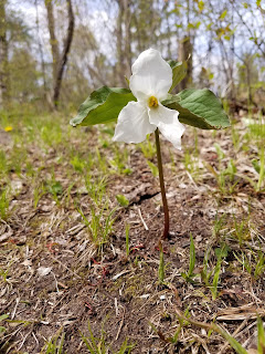
Naturally, there were many wildflowers along the way.


"From the Old Rookery for about 1/4 mile south on the Hemlock Creek Segment, as the pond slowly moves from one side of the trail to the other, there are currently a half dozen or so spots that is virtually impossible to not have to go through muck to cross. None are real long and the local volunteer chapter is trying to put logs across to help. However, the process of the pond moving may be years and it is unknown if the wet areas will grow."
And an old, rickety sign saying, 'Old Rookery'.


It was a nice trail all the way to Finohorn Road. Not really enough blazes, but it would have been hard to get lost if you know the general flow of the trail.
We reached this sign at 1:40 pm, temperature 57 degrees.


We started up again at 2:50 pm, temperature 57 degrees.
The first thing we did was cross the concrete bridge over Hemlock Creek. In short order we passed a man just off-trail looking for rocks. Having dabbled a bit in rock painting, I thought I recognized the look of someone who was seeking perfect oval rocks for painting.
"Did you find the best one?" I asked.
His answer was non-committal. But I found out that his job was rock picking, and his wife was down the trail with their two youngun's being the group photographer.
"How far did you go?" I asked.
"Maybe a mile - mile and a half at most," he said. I was dubious, but cheerful.
"Wow! You must have made it almost all the way to Bolger Road," I said. "That's where we're headed."
Again, he went back to his rock picking, and we decided to wish him well and start walking. After all, we had barely started, and we had 2.4 miles to go.
Within a minute we heard, rather than saw, the aforementioned party of three, with two kids far younger than I had envisioned and saw what could only be 'mom' trailing along behind them. The way the kids looked I knew in a heartbeat they had not traveled a mile or more down the trail.
"I hear you're the family photographer," I exclaimed in greeting.
There are moments in life you wish you could take back. This was one of them.
Once she offered to take our picture, there was nothing we could do but politely accept, and then we proceeded to get pictures with the sun behind us, in front of us, then two or three more "just to be sure". I know it took less than two minutes. It felt like ten. But on the plus side, we did end up with a very nice photo of the two of us.

Finally shed of our social obligations we headed down the trail with the intent of talking to no one else as we walked.
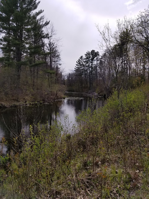
One of the first things you notice is not the trail, which was a broad, well-used dirt single track through the trees, but rather the river, which was fast, clear, and surprisingly loud.
There was a small bridge crossing, giving us a good feeling for how well maintained this piece of trail was. We weren't disappointed.

What we first assumed was rapids was actually the remnants of several attempts by beavers to dam this powerful creek, an effort easily thwarted by the volume and speed of the water rushing through. Broken bits of beaver dam floated downstream, jamming up one bank or the other while water rushed past.
 |
| Upriver |
 |
| Downriver |
What followed at this point for the next nearly two miles was a spectacular walk along the edge of Hemlock Creek, dotted occasionally with benches. The stream bed narrowed a bit, making the water deeper, faster and louder, and because we were hiking east-to-west, we were traveling with the flow of water, and therefore downhill.
At some parts of the walk the downhill aspect became a significant factor as the water rushed along past us.
One thing I noticed was that we encountered no Hemlock trees along Hemlock Creek. I'm sure they are somewhere to be found along its banks, but not on this two-mile stretch. Nevertheless, it is one of the more scenic stretches along the trail.
We did encounter blankets of flowers, including trillium, now in their peak, spring beauties, hepatica, trout lily, wood anemone, bellwort and others.
I want to commend the people who chose the route. The elevation changes are exceptionally well-done through here, including switchbacks where necessary. Erosion control, and ease of hiking, were well-planned the whole way. Also, there are many bridges built to help keep you dry, and we could tell this was a well-loved section of trail. Thanks, IAT heroes!
I have few complaints about the blazes, because for the most part it would be very difficult to get lost, but at one critical juncture the trail splits in two directions, and it's not immediately obvious which way is the correct way.

One sign, see above, points left and right along the river. We had just come from the picnic shelter, so the other way seemed like a possibility.
Then we saw the other sign, see below, that was facing the other way.


 |
| Ripple Marks on the rock |
The trail continued until it emptied out along the roadway entrance to the park, and we walked the last one or two tenths within sight of our vehicle. We ended at 5:52 pm, temperature still 59 degrees.
Location 2: The westernmost 0.1 miles of the Northern Blue Hills segment, between the intersection of County Road F and S Bucks Lake Road to the west and the trailhead sign on S Bucks Lake Rd to the east.
This left us with a bit of a quandary. We were really close to walking off the edge of map 10. We wouldn't finish it, of course, because there was connecting route and part of the Tuscobia segment on the other end, but still - if we just hiked one more tiny, little tenth of a mile, we could get off one edge of the map.
Of course we did.
We drove to the trailhead sign parking area on S Bucks Lake Road where the Northern Blue Hills segment loops northward, and walked the 0.1 miles of gravel road back to our car. I don't know what time we started. I don't know what time we finished. I don't know what the temperature was. I didn't even take any pictures.
But we did get off the map.
Running Total: 431.8 miles of trail covered; 37.5 miles ‘extra’ hiking/biking. End of Day 62.
No comments:
Post a Comment