Day 65: Chippewa Moraine Segment (Part 1), Chippewa River Segment (Part 2), Firth Lake Segment (Part 2), Chippewa County
Day 65: Sunday May 16th, 2021
Total Miles covered for the day: 5.7


As we rounded the north end of North Shattuck Lake, between North Shattuck Lake and North of North Shattuck Lake (it's true - look at the map), we passed over a venerable old bridge build in 1990 by the Ice Age Trail Council of the Wisconsin Conservation Corps. Bless their hearts. This bridge has held up VERY well.

The main reason we hiked this piece east to west was that it was far more downhill than up. If that patters to you, I encourage you to do the same.
Lake after lake, beautiful view after beautiful view. It's easy to see why the Dave Obey center was built here. This is indeed a showcase for what they want people to believe the whole IAT is like. It's a fantasy, or course, but for two miles we allowed ourselves to believe in fairy tales, if only for a little while.


 |
| One of a diminishing number of white trillium in bloom |
We reached the car at 10:50 am, temperature 56 degrees. The day was waiting.
Because we weren't planning on hiking a contiguous piece, we needed to go back and pick up our car at the Dave Obey Center. I listened once more to the abundant birdsong and then we were on our way to part 2 of our hiking day.
Since we discovered yesterday that the Chippewa River segment still existed (for now) and had not yet been turned into a blue-blaze spur trail, we decided to hike it today.
Unfortunately, we finally ran into the problem that we created way back in September of 2013. When we came through, way back then, there was still a trail sign in the Parking area on Cty CC that is just a little bit north of Cty Hwy Z. More, there was still a path that led to a dilapidated bridge with an IAT sign on it, and a trail on the other side that led north and ended up at the east trailhead, just like it should. Unfortunately, what we didn't realize at the time was that the official trail no longer crossed this bridge, but instead followed the same path that exists today, and much of the path we walked on that day wasn't even 'real' Ice Age Trail.
But we did claim 0.6 miles of trail that day, and if it were still possible to hike back the same way we went out I might have just left it at that, but the bridge is long, long gone now (thank goodness), with only a set of pilings remaining, and the trail that was there eight years ago has been reclaimed by the forest for lack of travelers.
In other words, the only way we could finish hiking the segment was to hike the whole 1.9 miles from end-to-end, and we would only be able to claim 1.3 miles of it as new trail miles covered. The rest had to fall into 'extra' hiking.
So we dropped a vehicle at the parking area on the roadside on Cty Hwy Z and then headed north to park at the other end, an excellent, large parking area with a kiosk on Hwy CC.


We geared up and started walking at 11:36 am, temperature 58 degrees, hiking north to south. The direction was chosen because that's the way the river was flowing, and we like to hike downhill where possible, assuming there is a choice. And what we got was basically exactly what we expected given that it was possible to assess a lot of it from the road.

The trail along the river tends to run along the top of the ridge for quite a while - the most logical spot - and provides an opportunity to walk up and downhill a lot over low, hummocky terrain while getting a great view of the fast-moving river. We were really glad we weren't being forced to walk at the water's edge.
As we walked the ridge I got the feeling that I was walking in the same place as others before me had passed for centuries, if not thousands of years. Anyone, man or beast, who wanted to walk along the edge of the river would almost certainly use this natural ridge as the best place to walk. Of course, rivers are fickle and prone to changes, building up and swallowing entire islands and gouging out new channels, and there is certainly more water here now than would have been present before the dam was built just downstream. Now that I look at a satellite map I can see that I'm probably wrong.
The hydroelectric dam at Cornell has been in place over 100 years, fixing the river in its current bed for at least that long, but prior to that the main river may have flowed over a slightly different course more to the east. If that was the case, this idyllic little hilltop may have been just an odd little feature that wasn't used much at all. I'll never know.
The segment along the river boasts adequate trail markings and beautiful trailwork. One area in particular was very nicely cut, as it drops off the top of the hill toward the road, then slices back toward the river while it first crosses, then follows a watershed through a narrow ravine. This area could have been a nightmare for hikers, but instead it becomes a feature of the trail and you can really appreciate the amount of work it took to design, then construct this 50 feet of trail in a way it would remain intact and beautiful for years.

Along the way we passed two nice couples making their way north who thanked us for all our work on the trail. We explained that we had actually done very little trailwork, and we were puzzled why they pegged us as actual trail volunteers. Perhaps it was Theresa's wardrobe, complete with leg gaiters and hiking sticks that made her look so 'official'. We'll never know.
There was one location where the trail did actually cut very near the water's edge, but it was in a spot that made perfect sense. Then we headed out toward the road to first walk along, then briefly on, the road itself. It was here we were passed from behind by a long-legged man who was making an out-and-back journey along the trail. We eventually crossed paths with him again quite a bit later as he was making his way back to his car.
Overall, this was a broad, dirt trail, about 3 out of 10 on the rocks-and-roots scale. There were a few of each, but nothing to write home about.


After we crossed the highway, we went north onto the piece of trail I had hiked two nights before looking for the 'real' Firth Lake Segment. The trail from the road goes uphill, then uphill, then uphill a little more, only to plunge back downhill to the creek on the other side, a total of about 0.3 miles. This is where the new Firth Lake segment will eventually connect when it gets cut through across the Krank Preserve, but as I mentioned in yesterday's blog, it's certainly not there yet.

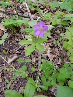 |
| Wild Geranium |
 |
| Woodpecker Tree |
This part of the trail is also quite hummocky, with more hiking up and down than straight across, it seems. Not that the hills are very tall - there's just always another one right around the bend. And again, I was impressed with the trailwork. A great amount of effort had been put in to avoid causing damage to the natural landscape, which naturally makes it easier and more pleasant for the hikers.
At some point we started rewalking the trail we had hiked in 2013, though only one part looked genuinely familiar going along the western edge of the pond. For some reason that particular set of trees had been engrained in my memory.


Fairly soon we walked out of the woods to the waiting car. The time was 1:19 pm, temperature 61 degrees. More hiking to do.


No comments:
Post a Comment