Day 179: Connecting Route, Manitowoc County
Day 179: Saturday, May 28th, 2022
Total Miles hiked for the day: 7.7; Net Miles 7.7
Location: Part of the long Connecting Route in Manitowoc County, between the east end of the Walla Hi Segment and the intersection of County F and Spring Lake Road.
7.7 Miles of trail covered
There are days on the trail where everything goes just right. You wake up in the morning, well rested and happy, enjoy a hot, nutritious breakfast, meet a bunch of happy smiling people and then spend a day taking a leisurely walk with like-minded new friends. Add to that amazingly pleasant weather and it's a formula for a great memory.
Point 1. Woke up sleeping in our van (no, really - that's a good thing) at a farm in Newton Wisconsin, where we ended up because there was nowhere to camp and a good soul came to our rescue from Facebook. It was our second night here, and it's a nice, quiet place to sleep.
Point 2. Out in the middle of nowhere is a restaurant by the name of 'Whispering Orchards & Cafe'. As the name implies, it's a lot more than a restaurant. There's a craft store, a café, and yes, an actual orchard. It's out on County Road MM, and you should definitely go there.

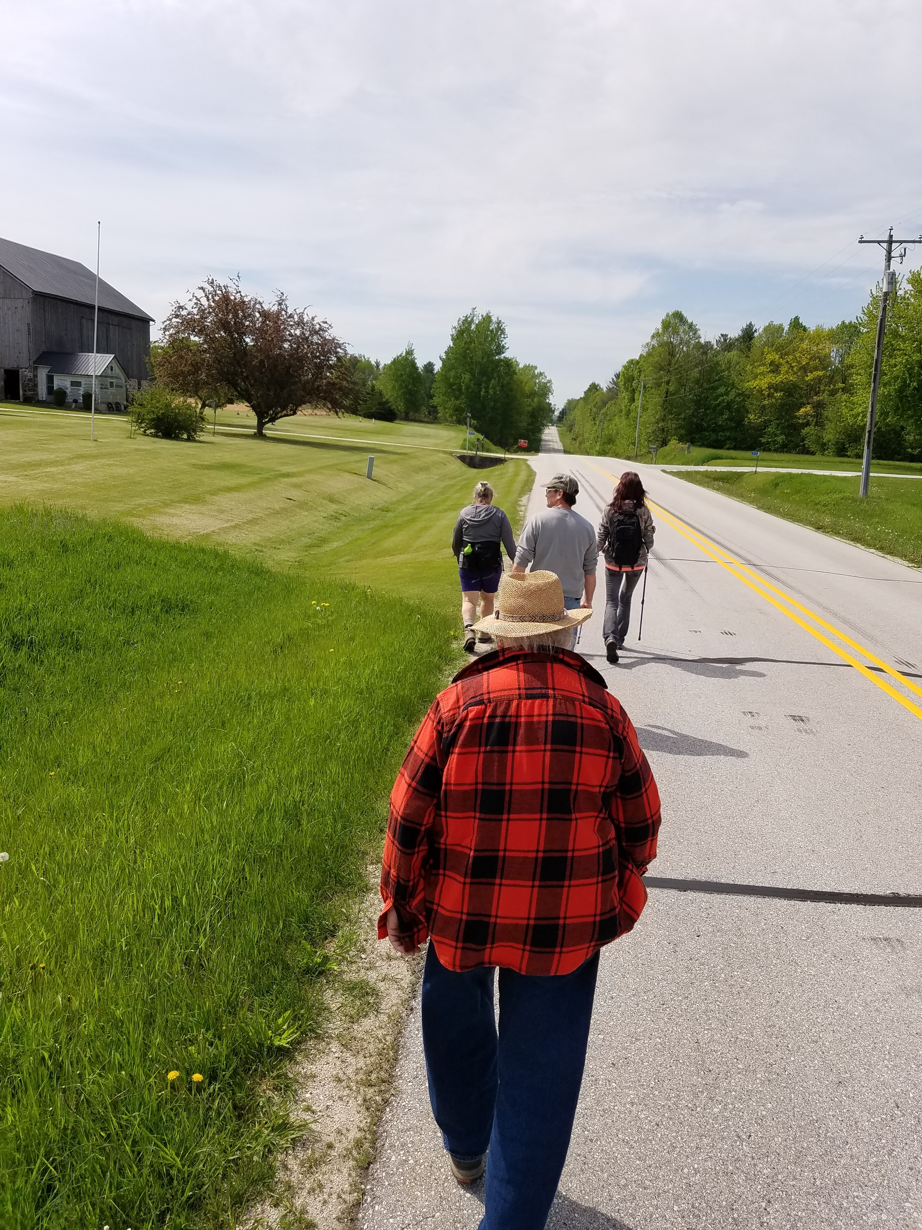
Point 3. Theresa decided that today would be a lot more fun if we had an official Snail hike, and she was right, as usual. At 9:00 we met a group of hikers in the parking lot in the middle of the Walla Hi Segment. It's a great place to meet, because there is quite a bit of parking available, and it had the advantage of offering our hiking group a ton of options.
Some of them were there just to hike the Walla Hi Segment, which was great. Some were there to hike the connecting route with us, and some were there to hike the connecting route headed south. It was funny, in a way. Like so many of our hikes, we were merely the catalyst to get people out walking. Yes, people like meeting us, and getting their patches, but they have their own agendas, their own needs. Once we take the group photo the 'group' portion of the hike is over. If we end up hiking with a few of them, that's great. But the rest of the day isn't really about us. We're just happy that everyone is having fun and gets what they need.


So when all was said and done we drove our cars and a few people to the east end of the Walla Hi Segment and parked a couple target vehicles along the the side of the road on Mueller Road. Perfectly legal. More on that later.
Next, we drove ourselves north and east to our first launch point. As usual, Theresa and I were introducing the group to leapfrogging, and the six of us started working our way along West Washington Road back to the park.


When we got to the waiting cars, which had been there long enough for us to walk about one mile, I met Laura Kibotzki, Landowner. I smiled as we walked by and headed to the cars. She decided she needed to come talk to me.
"Are you the one in charge?" That didn't sound good.
I'll cut the story short. Laura Kibotzki, who lives on the corner of Mueller Road and South Cedar Lake Road, doesn't like it when people park roadside on Mueller. She's not anti-hiker - in fact, she was instrumental in creating the hiking trails when they were put into the park - but she's strenuously against having people parking along the road, because the cars interfere with the view out her living room window.
I'm not judging. Well, OK, maybe I am. I don't like being accosted by someone for doing something perfectly legal and normal, like parking. I can suggest to anyone not wanting to meet Ms. Kibotzki that you can park along the road a little further north on South Cedar Lake Road. Hopefully, the trail will soon continue through the woods to traverse the IATA Brownrigg-Heier Preserve, thus coming out on Rockville Road and avoiding this problem altogether.
I don't recall where we parked next, but we spent most of the morning hiking in short stints, between one and two miles in length. In that way we continued working our way north.

The reason we were walking short stints was to keep us close to the cars, and there was a reason. Unlike most hiking days, we scheduled an "extra" event to take place in the middle of the day.
We committed to being at the Pine River Dairy on English Lake Road between the hours of 12:00 and 1:00 so that we could buy ice cream for all comers. It wasn't a burden. The ice cream there is only $0.25 cents a cone. That's not a typo.
Some people did show up for ice cream, but we missed the opportunity to buy most of them their cones. While we were busy laughing, having fun and handing out patches, people kept showing up and buying their own ice cream.


I have often lamented roads that have little to no shoulder, or roads that have the white painted lines so close to the edge that it makes the way seem dangerous and foreboding. The roads, in theory, are open to all, for use by those on four wheels, on two wheels, or on no wheels. Yet so many of those roads so clearly favor the four-wheeled traveler that the rest of us are forgotten, shunned, or even loathed.


Alas, we could not hang around and enjoy ice cream and still achieve our goals for the weekend. Those roads, as they say, do not hike themselves.

Yet take this road as an example of the opposite. If there were ever lines on this road, they are long gone. The result is transformative. Instead of boundary lines, meant to keep everyone in their lane, there is only one track that all must share. It is a broad path, and there is plenty of room. People can walk safely, following the convention of walking on the left side of the road, knowing that if a car drives by they just move to the other side of the road. There are no lines to constrain them. Most of the drivers wave as they go by, and we wave back. When two cars happen to pass near at the same time, then the hiker graciously steps a bit to the side, giving way to those who need a bit more space.
This is one of life's great lessons, really. There is but one path for all of us to share, and we need to find ways to make sure we all make room for one another to move on that path together. Travel with purpose. Give space to those in need. Maybe even wave to those you meet along the way. If we stop painting metaphorical lines meant to keep everyone separated, maybe we'll all learn to share a little better.


Someone local has come up with a name for that lake, however, and they went to the effort to put up a sign.

Works for me.
We ended our day just after 4:30 in the afternoon, having made it as far north as County Road F. The temperature was still hovering at 51 degrees, down from a high of 58 today, and for once we decided to call it quits early. We ended up going all the way back to Rhine Center to have dinner in the Rustic Rhine Saloon. You can almost see the ghosts of tavern-goers past, taking up the empty barstools or seated around the wood stove on a chilly winter Saturday afternoon. The food wasn't bad, either.
The tally:
- At least 8 new Snails today
- Completed map 91
- 7.7 new miles covered
- 259.7 miles to go
Running Total: 1198.1 miles of trail covered (877.3 hiked), 185.5 miles 'extra' hiking/biking. End of Day 179.
No comments:
Post a Comment