Day 136: Loew Lake Segment, Connecting Route, Washington County
Day 136: Sunday, February 6th, 2022
Total Miles covered for the day: 6.1
Location 1: The Loew Lake Segment
4.9 miles of trail covered
Last night was exhausting.
First, we drove 45 minutes to get to the start of the Eagle Segment, hiked the entire segment, drove back down to Janesville and hiked 2.24 miles of the Janesville segment in the dark, with howling winds and bitter cold temperatures.
Then we got back to the Airbnb and Theresa spent two hours wrapped up in a heating blanket just to try and recover before getting to bed later than either one of us would have liked.
This morning, we woke up too early, and had to pack up all our stuff and haul it out to the van before we could leave. We tried to do it as quietly as possible, because we didn't want to wake our host before leaving. In that, I believe we were successful.
We were on the road relatively early, and decided that of all the places we could still go hiking on our way home, the top priority would be knocking off that last 'Do this in Winter' segment, the Loew Lake Segment.
So we bypassed all the hiking we had left in Rock County, blew through Walworth County, left Jefferson County in our wake, bypassed Waukesha County where we had hiked Eagle the day before, and ended our trip at the southern border of Washington County, a trip that took over an hour and a half with one break for gas and coffee.
This explains why we didn't see an Ice Age Trail sign until 11:20 am. The temperature had risen considerably, and it was already 30 degrees today.
The thing about the Loew Lake Segment is that the parking is terrible. I mean, it's lousy. There is parking at the south end, at a large multi-purpose lot, and there is parking at the Emerald Drive parking area, a good tenth of a mile from the trail itself and nine tenths of a mile from the north trailhead. In between, there is nothing.
The trail crosses, and even walks along, Emerald Drive in a few places, but woe be to the traveler who thinks they will park anywhere along this roadway. This means the easiest thing to do is plan a four-mile hike, followed by a 2.1 mile hike that would take you past the end of the segment and all the way to the parking area for the Holy Hill Segment to the north.
Which we distinctly didn't want to do. We were too tired, and too uncertain of our ability to finish the whole segment for us to start out with a 4-mile leg. So we did the next best thing, which was to use our crisscross method of hiking to chop it up in bits.
We started out with the only risky part of the plan. We hiked the 0.4 miles of roadway that ran north of the cemetery. Theresa dropped me off on the road and went down to park at the Cemetery. By the time she was parked and walking I was within just a few minutes of the car, and I could pick it up and go get her on the other end. It worked slick. 0.4 miles down, 4.5 to go.
For our next trick, Theresa dropped me off at the trail right next to the cemetery and I started walking south on the 1.5 mile leg to the south trailhead. She drove there and parked, and headed north. The time was 11:49 am.


She made her way out of the pines a few minutes after I arrived with the car, and we headed north for the next leg.
This one wasn't so convenient. It was only eight tenths of a mile along the loop that ends on Emerald Drive on both ends, but there isn't a place to park on either end. So we had to make the longer walk of 2.0 miles from where we had left off to the parking area. This included the whole first loop, then a short walk on the road again, and then half of another loop until we reached the spur trail.
I started this walk at 1:18 pm. The temperature was up to 35 degrees, and the snow was getting melty.


I really enjoyed this section of the trail. There were parts where the side slope was too steep, making for a sloped tread, but much of it was pleasant and woodsy. It was hilly, but they were small hills, and the reward was a series of gigantic oak trees and a pleasant bench built into a board walk that goes over a natural spring.


Welcome to The Snails, Lee family!


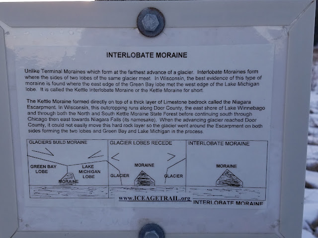
I did take photos of the famous Esker sign, and one describing the Kettle Moraine State Forest.


I ended up taking several drives back and forth in front of the trail crossing, then took too long a break before making the next loop. Suddenly my phone rang with an unfamiliar number.
"Hello?"
"Where are you?" came Theresa's voice.
"On my way. Where's your phone?" I asked.
"In the car seat next to you."
I looked. Sure enough, there was her phone. That didn't go as planed.

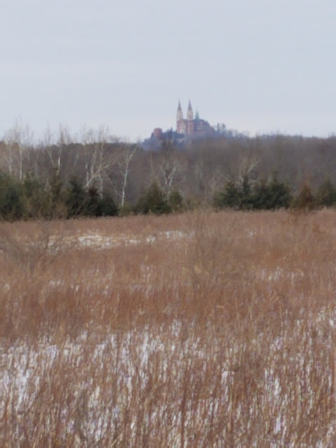
Let me just take another moment to revisit an old rant. Who decides where these things are going to end?!? This was ridiculous. There was a large parking area to the south, and another one to the north. Why didn't they just take Loew Lake all the way to the beginning of Holy Hill? I mean - who cares if some of it is along the road? Didn't we just hike over a half-mile of road on this segment? Here we were, standing at the top of this hill at the end of the segment, and there is absolutely nowhere to pull over, let alone park. It was barely safe enough to stop in the middle of the road long enough to snap a picture together at the end.


When we crossed paths, I offered to take her to the top again with the car and have her walk down instead, the same way I had come. It was late, she was tired, and she decided that if she turned around now to go back and tackle it from the other end, it was never going to happen.
She kept going.
So I walked with her for a while, before turning around and making my way back to the car. I photographed one more interpretive sign on the way.
And this was the last picture I took of Loew Lake before reaching the car.

Location 2: The Connecting Route between the north end of the Loew Lake Segment and the south end of the Holy Hill Segment
1.2 miles of trail covered
So here we were with a problem. We had just ended our hike at an absolutely terrible spot, with nowhere to park. Eventually, we would need to come back here and figure out how to end a hike at this same spot going the opposite direction.
Or we could just do it today. I had actually already scoped out the parking at the Holy Hill end prior to picking up Theresa. I knew it was downhill almost all the way, and we decided Theresa should keep walking the road to the parking area, downhill this time, and I would take the uphill leg.
Which we did. I started walking about 5:10 and made my way quickly along the road as night fell. I handed Theresa her reflective vest as we crossed paths.
Just as I was hiking the last two tenths of a mile, I spotted a night hunter up in the tree.


It was a late, but satisfying trip home. Our 'winter hiking' list was done. We didn't finish any maps today, but we did complete another entire segment, and some connecting route besides. I never did figure out why people felt Loew Lake would be best hiked in winter. Maybe the flies or mosquitoes are bad. It certainly didn't seem like it would get flooded easily.
As we drove, we talked about what we should do next. The ice cleats were turning out to be huge assets, that turned ice-covered hills into easy walking. The hills in the Kettle Moraine area, we knew, were covered in loose rocks that were hazardous for hiking. We decided we would focus on that area next, hoping to get through it before the ground thawed out and let those stones roll free.
I've looked. There is a LOT of trail through Kettle Moraine. I'm not sure we'll make it, but we can sure give it a shot.
Running Total: 921.1 miles of trail covered, 146.7 miles 'extra' hiking/biking. End of Day 136.
No comments:
Post a Comment