Day 143: West Bend Segment (Part 2), Washington County
Day 143: Sunday, February 27th, 2022
Total Miles covered for the day: 4.9
Location 1: The West Bend Segment, from County Road D to Washington Street
2.6 miles of trail covered
"Of all the paths you take in life, make sure a few of them are dirt. - John Muir
Sunday is usually our go-home day, and today was no different. Not until the end, anyway.
Theresa was unusually eager to get going this morning. Last night we looked at the maps, and we felt like if we got going early enough we could finish the five miles of trail left on the West Bend Segment before heading home.
Doing this would mean that we had truly overachieved over the last two weeks. It was ten days ago that we stood metaphorically at the north end of the Parnell Segment, staring down 30 miles of the Kettle Moraine Northern Unit between us and West Bend. In those ten days, of which four had to be spent back in Wausau at work, we have covered the Parnell Segment (13.9 miles), the Milwaukee River Segments in both Fond Du Lac and Washington Counties (11.2 miles), the Kewaskum and Southern Kewaskum Segments (3.2 miles) and even a little bit of the West Bend Segment as a filler. Finishing this segment would mean we were down to only 24 segments left to hike, plus a little bit of connecting route.
OK, a lot of connecting route. But it's still amazing to us.
By 9:50 am we were checked out of the hotel and had cars in position. The first one was the easiest. Theresa drove the 0.1 miles to the Culver's parking lot and left a car there, then we drove a few miles north to the north end of the West Bend Segment. It was 27 degrees, there was only a light 10 mph breeze, and there were no clouds. We couldn't ask for a better Sunday.
I have mentioned before, and I will say it again here. There is nothing - and I mean NOTHING - to identify the north end of the West Bend Segment. Not even a yellow blaze visible down the trail if you stand at the end and look down as far as you can see. Even looking the other direction onto the South Kewaskum Segment you only see one yellow blaze on a telephone pole if you know what you're looking for.
If I hadn't had the exact coordinates of the north end of the trail, I would have had no way of knowing I was in the right place until I took a two-tenths of a mile journey south. I'm going to give them the benefit of the doubt and say it hasn't always been like that, but they could sure use a little emergency maintenance in the form of yellow blazes.

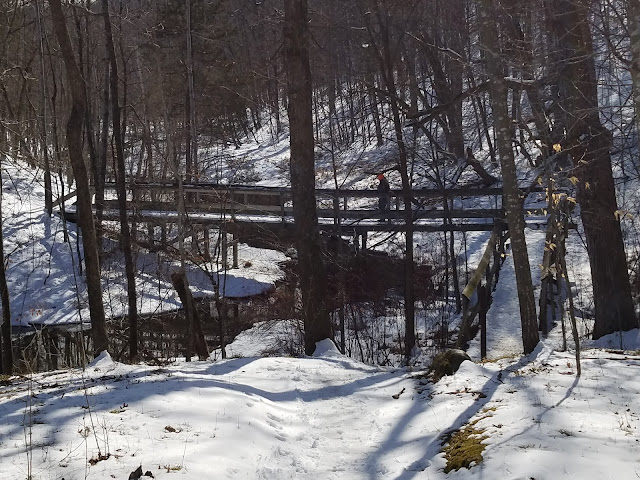
But then the trail took a 90 degree turn to the west and and headed off into the hills. And I do mean HILLS. That was one of the most amazing discoveries for me, was learning just how rugged this whole section was.


Up, up, up we hiked. It wasn't steep, but it kept going up. 20 feet - 60 feet - 100 feet in elevation. And oddly enough, we weren't alone. A lot of the trail through here is shared use, and bicycles are allowed. You wouldn't think that would be much of an issue in winter, but we saw almost as many fat-tired bikes as we did hikers.
We also saw a small flock of red-bellied woodpeckers, which was a treat. Far too often we hike the trail with no sign of a birds anywhere.

This photo gives an idea of the scale and steepness of the hills. This tree had fallen in such a way that it bridged the span, and hikers simply pass underneath.

Standing at the spot where the trail came out on the north side of the parking lot, it wasn't entirely easy to spot the trail sign on the other side of the road. However, when we moved around the small island of trees in the way it it was hard to miss.

On the way up I met this fine, bearded fellow.


Sometimes you run out of things to talk about on the trail, and your mind starts to wander. I had been spending a lot of time on this hike thinking about trees.
And I thought to myself, 'What do the trees think about?'
Out loud I asked Theresa, "When the trees get older, do you think they have more to say, or less to say?"
"Less."
I waited, but there was nothing else forthcoming. There's a joke in there somewhere.
"Do they talk loudly or softly?"
"It depends on who they're talking to."
"Do their voices get deeper as they get older?"
"Yes."
This was tougher than I thought it was going to be.
"What do you think they like to talk about?"
She didn't bite. "What do they say to you?"
I guess that was a fair question.
"They don't seem to have much to say to me today. I think they spend most of their time talking to each other."
"What do the hills have to say?", she asked me.
This threw me for a loop. Here I was anthropomorphising the trees and she went right for the ground beneath our feet.
"The hills aren't talking to me either," I told her. "They're too busy talking to the trees."
"The hills talk to some people," she said, enigmatically. That as where the conversation ended.
----------------------------------------------------------------
One of the amazing things about this Segment is how close it is to civilization, and yet how remote and distant it feels. Surrounded by the city of West Bend, the only reminder was the occasional intrusion of highway noise, and even that was subdued for most of the trip.
Shortly after spotting this sign we crossed Park Avenue.


Location 2: The West Bend Segment, from the parking area on Wheat Ridge Lane to the southern trailhead on Paradise Drive.
2.3 miles of trail covered
The wind had picked up a bit, and we did the best we could to not have it directly in our faces. To that end, we were hiking north to south with each leg.
We touched the sign at 1:04 pm, temperature a balmy 33 degrees. I stayed layered. The wind was chilly and damp.

Right at the trail sign, on both ends of this leg, is a sign warning hikers that there are closures due to logging that will be happening at some point during the fall or winter season. Well - it was already pretty late into the winter season. We were prepared to do an out and back if necessary, but figured if we did encounter any logging it would be possible to bypass it on a Sunday. It never became an issue. There was no logging.

We found this perfectly lovely bench, and couldn't help ourselves but to take a long, leisurely rest to celebrate our accomplishments over the last two weekends.
This was where Theresa had her epiphany.

"I'm going to write a post on Facebook," she told me. "It's time to add to the 'I hate hiking' series."
I wasn't sure where this was going, but I was feeling relaxed, and even a little sleepy-eyed on the bench, so I just let her talk.
She went on to tell me how she envisioned her post would read. How when she started this whole adventure, she hated hiking. That for eight hundred miles, she kept hiking, hating almost everything about it, especially the walking part of it. She didn't like walking. And she didn't like hills. She didn't like rock, or roots, or mosquitoes, or gnats, or flies, or pokey branches and bushes. She didn't like heat and she was afraid of the ice. But then something amazing happened. Something astounding. Something miraculous. She discovered that with the right equipment, she liked hiking in the wintertime. No, she LOVED hiking in the wintertime! She could breathe! She didn't get overheated! There were no bugs! No Flies! No rattlesnakes! And with the right gear for her hands and feet, she didn't have to worry about pain in her fingers and toes, and she didn't have to worry about slipping and falling. Today, she realized to her own amazement, there WAS some part of hiking that she could actually LOVE.
She still hates hills, though.
As we sat on the bench, two hikers passed us by, moving fast. We would meet them again later as they made their way back.


"Make sure there's lots of snow in the background."
That wasn't hard - there was snow in every direction.


"OK," I said, "How about one by the river?"


When we reached the scout camp, Camp Silver Brook, there was an astonishing array of signs warning hikers to stay away from the camp, and off of any private trails. Some of the signs bordered on rude, and I was a little surprised the Girl Scouts would take that stance. It's hard to imagine what they must have encountered that would have made them respond that way.
This sign, on the other hand, told us a little more about eskers. We had the impression that eskers formed as tubes of water flowing through the ice. Apparently (and logically) sometimes those rivers flow along right on top of the underlying earth. It's not the first time we've seen this sign, but it was the first time either of us really looked hard at it.


It was 3:04 pm and the temperature hit 35 degrees. The snow was melty under our feet for much of the hike, but we weren't getting all the ice balls on our cleats like we were the other day, or at least nowhere near as bad.

This might have been the end of a great weekend. As I mentioned, we couldn't have asked for a better Sunday. Except that on the way home, while cruising down the highway at a road-clogging 72 miles per hour, my van decided to take a nap.
It's a discomforting feeling having your vehicle suddenly shake and cough violently, then after pulling over to the side of the road, having it simply refuse to respond to any and all attempts at resuscitation.
Broken down on the side of the road, I was deeply grateful that Theresa was right behind me, in the other car, and we were able to simply transfer all the gear over to the Prius and drive home. This thing could have broken down anywhere. And if you've done any kind of serious hiking on the Ice Age Trail you know just how isolated and remote that 'anywhere' could be.
But no, I was right here on the Interstate. We called the Insurance company. "Tow truck should be there in 55 minutes or less."
I told the officer, who had stopped by to check on us, that we were fine, and we would be waiting for the tow truck.
"You sure?" he asked.
"No problem," I assured him. "We have warm clothes, a second car, food, beverages - we even have a portable toilet with us." This brought a slight chuckle.
The officer left, and we waited. A full two hours passed before we were picked up. Wires had been crossed, and let's just say I'm glad the tow service did a better job of following up than our insurance company. But who was I to complain? The tow actually cost only about $150, and I was expecting much more.
The repair bill, on the other hand, is going to be a lot higher. We got home a little later than planned, and short exactly one vehicle. But we were home safe.
UPDATE: We broke down just north of Fond du Lac, but chose to have our vehicle towed closer to home, to Oshkosh. We figured we had a dead fuel pump, and we weren't wrong. When that was replaced, they were able to get the car running - sort of.
"Well - we have a problem," the shop told us. "It's running, but there's still something wrong with it."
I'll spare all the gory details. It is now eight days later and we have received the good news that the repair will only cost us about $6,500. We're actually celebrating at that. A new van would cost on the order of 30-50 thousand, and if the old one had needed a new engine (a very real possibility given what happened to it), it would have been more like 14 or 15 thousand. Given those options, a mere six or seven grand seemed like quite a bargain.
The van isn't home yet, but I'm crossing my fingers that this will be the final tally.
Running Total: 956.1 miles of trail covered, 147.6 miles 'extra' hiking/biking. End of Day 143.
No comments:
Post a Comment