Day 163: Sturgeon Bay Segment (Part 4), Door County
Day 163: Sunday, April 17th, 2022
Total Miles covered for the day: 3.2
We spent last night in the AmericInn in Sturgeon Bay. As hotels go, it was a fine place to stay, and breakfast was passable. To be honest, the hotels are starting to blur a bit, and I don't really have much to distinguish it from other similar stays we've had along the trail. We were only there for the one night, so it was up and out again this morning.
There was a Snail Hike planned for today, but for the first time ever, no one showed up. Well - not exactly the first time no one was there at the beginning, but no one even tracked us down during the day. I attribute this to the fact that it was Easter Sunday.
Today was a gorgeous day for hiking. It was sunny, with no wind to speak of. The temperature was 35 degrees when we started the day and 39 degrees when we finished. We had the trail largely to ourselves, which meant we could enjoy our own pace, and come and go as we pleased.
Prior to the start of the hike, we had time to drive around a bit and check out the park, and the Sturgeon Bay shoreline. This fine fellow helped to remind me that no matter what else happens in this world, there will always be work for the undertaker.


Having never been to Potawatomi State Park before, I was surprised to see how much of the park remains undeveloped. There are acres and acres of land with nothing on it but trees and rocks, crossed by the occasional foot or mountain bike path. One has to drive quite a ways before getting to the camping area, and even that is fairly widely dispersed, campsite to campsite.
There are surprisingly few 'park facility' buildings, though we saw one very near the campsites that was fully enclosed and one that was a combination camp store and nature center, which was not open when we drove by.
Our plan is to come back here in September to do our 'final hike', so we decided to go no closer to the Eastern Terminus than the 1.7-mile mark at Daisy Campground. This was in fact our meeting spot for the Snail Hike, and at 11:00 we knew for sure we were alone today.
We dropped one car off there at the very limited parking area (room for about five cars total) and then drove back out of the park. We made our way to the north end of N. Duluth Ave, where we found limited parking at the end of the dead end, just outside the park. This was where we started our day.
At 11:23 am, the skies were sunny, the winds were light, and the temperatures mild. The waters of Sturgeon Bay were placid and clear, and we couldn't have had a nicer day for a hike.


Immediately upon entering the park from the south, the trail takes a severe bend to the east to go immediately to the water's edge, and we hadn't gone 20 feet before we started to encounter all the fun the IAT can offer. There were rocks, roots, mud, and downed trees across the trail. It was level, but even that didn't last forever because later on there were also hills and stone stairs, but I don't want to get ahead of myself.


Whenever we stopped long enough to look around, especially out toward the water, we saw lots of gulls, mergansers, cormorants, and a few other big-water birds. The trail stayed very close to the shoreline for quite a while. There were numerous places where it was possible to take a 35-foot side-trip down to the rock beaches.


When we reached the spot called 'Hills Point', there was a former parking area that had suffered permanent erosion damage. As a result there are fences up, preventing vehicles from getting anywhere near the eroding shoreline. That was the spot where we left the shoreline and started heading up into the hills.
The first thing I spotted was an Easter Egg that was placed on a rock next to the trail. I don't know who left it, but it brought a smile to my face.

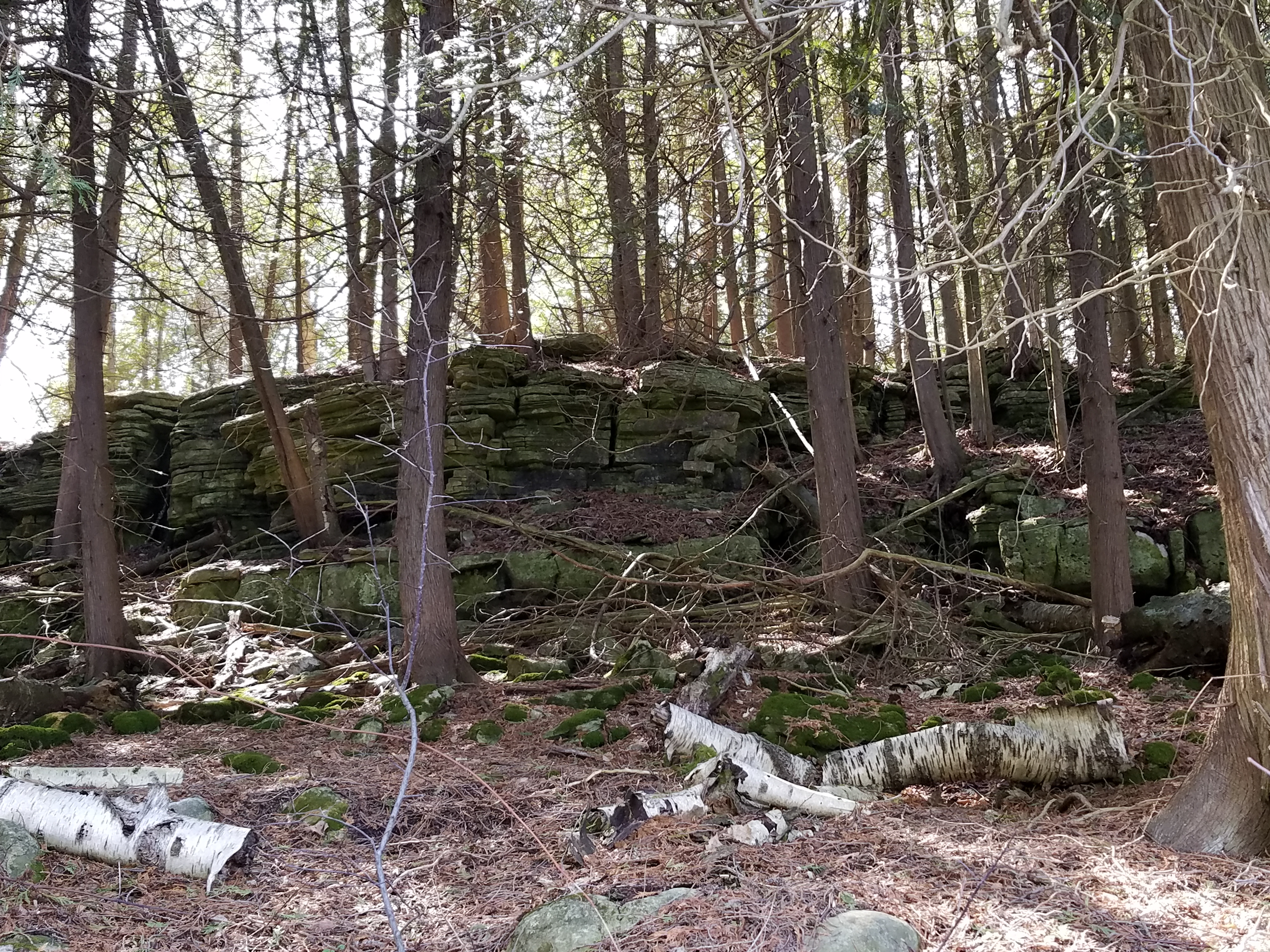
This was our first real taste of the shores of ancient Lake Nipissing, which were steep and stony. Much like the shoreline today, where there is a significant drop-off in many places, creating scenic limestone cliff faces along the shore, Lake Nipissing had a similar look and feel to it. Lake Nipissing is the long ago lake that was formed when the Great Lakes outlets to the north and to the south were higher than today, thus creating one, very large lake rather than the separate lakes you see today.
This spot took us up the steep face of one of those limestone cliffs, using stone steps placed by some forgotten but very much appreciated work crew.


There were a couple of switchbacks to make it easier, made from big limestone slabs. They were pretty evenly spaced, but there was occasionally a pretty big step up.

I didn't realize it at the time, but the residual hill we had to climb after reaching the top of the exposed limestone was actually the shoreline of a much older lake, Lake Algonquin. If you read the history of the area, you come to find out that the water levels from long ago are actually a little hard to judge, because while the shores of Lake Algonquin currently ride a good 80 to 100 feet above the current water level, it isn't just a simple matter of there being less water.
When the glaciers were here 12,000 - 18,000 years ago they were several hundred feet thick. And even though the land was mostly rock, the immense weight of all that ice pressed down on the earth, compressing and subverting the earth itself. As the waters melted and the ice receded, the earth sprang up, slowly, like memory foam made of stone. Exactly how much it was compressed, how much the earth rebounded and how much water was is very difficult to judge.
Once we reached the top we enjoyed a nice stroll on the bluff, and then plunged down the other side again and back to the shore, though not quite as steeply. The shorelines are more definable here, if you know what you're looking at.
Back along the shore, we took our time, stopping at every bench to sit and enjoy the lake and the beautiful day. We were in no hurry whatsoever. A small flock of golden-crowned kinglets decided to stop by and see if we were giving out treats. We weren't.
I spent some time playing with limestone rocks down at the rock beach. Then I spotted this guy. Say what you want - salmon are apex predators in the great lakes, and there are not to be trifled with.


No comments:
Post a Comment