Day 165: Table Bluff Segment (Part 3), Connecting Route (x3), Dane County
Day 165: Saturday, April 23rd, 2022
Total Miles covered for the day: 12.7
Location 1: The linear trail portion of the Table Bluff Segment, between the parking area on Table Bluff Road and the awesome parking area just off of Scheele Road.
2.4 miles of trail covered
It was an early start for the snails, but that didn't stop a whole herd of hikers from showing up to get their walk in for the day and their Snail patches. When we pulled into the parking area at 9:20 am, the lot was already more than half full, and this was a BIG lot.

It is the very definition of an oak savannah, with an authentic 10,000-year-old feel to it, a landscape untouched by the influence of man.


The hikers came prepared for the day, which was dramatically warmer than the last time we went hiking. Temperatures today got up above 50, and it was a magnificent day for a walk.

Handing out Snail patches to a new group of hikers is always a lot of fun for us.


Everyone say SNAIL!

And - a few close-ups.


This wasn't everyone we would see today, but these were the folks who were there at the start. As usual, there were several options about how far people would be walking. Some chose to hike the whole segment, so we shuttled people up to Pine Road so that they could hike south and play 'Catch the Snail'. Others chose to start at different spots, and hike different directions - honestly, I'm not sure where everyone scattered to. By the time all was said and done we had but a single person hiking with us.

I know that every segment along the trail has highlights. There are things to love about all of them, and certainly there are times and conditions where each might be considered awful. But somehow I can't imagine any scenario where I would come to this trail and not think of it as one of the most lovely of all.

And here was our first snail sighting. These were folks who met us in the parking lot in the morning, then simply started hiking north, having already placed a target vehicle for themselves.

And then a few minutes later we crossed paths with this young woman who was out solo hiking. She caught up to us from behind (no big feat, that) and knew that the Ice Age Trail was 'a thing', but hadn't really set her sights on the whole trail, or at least not yet.

And then a few minutes later some of the road hikers caught up to us. I checked my clock. 10:22. Well, that game didn't last very long. 😂


Anyone familiar with oak savannahs knows that fire is a critical element to maintain the balance between open prairie and forestland. As we were making our way out into the open, getting ready to peak out on another hilltop, we found the remnant of a recent planned burn.

And oh my goodness, 10:24 and already another pair of hikers has caught up to us from behind.


And, two minutes later, another pair.

Maybe if we didn't spend so much time yakking we wouldn't be so easy to catch! But then - it's the yakking we like, so - it was a great day.

And a few more...

I tried several times to get a good picture of this little guy. These two were the best, but it failed to capture his true essence. If you want that rakish, devil-may-care, don't mess with me hairstyle, just bring photos of this guy to your stylist. He OWNS 'windswept'.


I had a great time walking and talking with these folks for a while as we made our way down the hillside.

There was a nice switch-back that enabled us to descend a somewhat steep hillside, then after crossing an agricultural field we saw that the trail went up onto the hill on the other side. Some of our party that had passed us earlier can be seen making their way up the opposite hillside.


Down at the bottom of the hill a sign has been mounted giving both credit and thanks to the people who have worked and contributed to preserving this 460 acres of wetland, prairie, savannah and woodland.

It was at this point that we were actually leaving the Holmes Preserve. The sign identifies that there is a loop trail available that can take the hiker back north, if desired. That is definitely the road less traveled, but if you have time I can guarantee you would enjoy the trail.

And since I was slowing down enough to read signs, and most of the people we were hiking with had moved on ahead, I took time to note some of the early spring greenery that was popping up, like these young nettles.

And this pretty thing, which I have quite forgotten the name of.

And here is a wood anemone just breaking free from winter slumber.

Heading up the hill, where it is most needed, a bridge took us over a relatively new ravine.

There was even a sign explaining how this ravine got here.


My first flower of the year!!!

Eventually we left the picnic table. We weren't in a hurry, but it was time to move on. And then - at 11:36 am - we caught sight of the most infamous full-time resident of Table Bluff, and maybe the entire IAT. A two-foot-long alligator wearing a blue polka dot bikini and a come-hither grin.

We are a strange race, we humans. I am fascinated in the artistic creativity that went into this post-modern piece of concrete eroticism. It's preposterous, of course. I mean - who ever saw an alligator drinking with a straw? And yet travelers are drawn to this thing sitting - no, lounging - on the side of the trail, and most are compelled to take at least one photo. Some go to great length to mimic the pose, laying on the ground in an act of repose that somehow borders on bawdy.

And while we were busy talking with her, another gal came trekking up. She, too, had been trying to find us today. Apparently today was a great day for catching snails. I'm embarrassed to say I can not recall the name of either of these two women, but in my defense some time has elapsed between the hiking and the retelling of the event, so details of that nature are bound to get lost.

Well, this turned into quite the talkathon. Theresa was in full, glorious snail mode.

While we were standing there, I took this shot to show that even here, in the "wooded" part of the segment, there is an openness that you don't find in most forests, and because of the fires that routinely come through, you don't see dead branches or downed trees for the most part. Those are consumed, leaving only the park-like widely spaced trees.

Eventually, of course, we moved on. The rest of the hike was spent basically following the semi-open ridgetop, making our way back to the waiting cars. None of the trees had leafed out yet, but the warm spring air was making this a truly enjoyable hike.

More spring flowers!!

What made this shelter so unique was that it is the only one I saw on the whole Ice Age Trail that had a gas grill sitting there, apparently available for anyone to use. The view was spectacular, as we were sitting atop the rocky bluff we saw earlier this morning.

Here we also found excellent interpretive signs, talking about the region, the topography, and the trail.


We met a woman on the way down the hill who was hiking alone. I asked her if she was looking for Snails. She said, "No - I'm looking for rattlesnakes."

We actually spent a long time in the parking lot chatting with the remaining hikers who were still around and getting a mini-tour of a vehicle that was a cross between a minibus and a motorhome. It was small enough to fit in a normal parking space, but big enough to provide pretty comfortable accommodations. It had decent gas mileage, too, or so we were told. I didn't take any photos but it seemed like a cool thing. I sort-of want one, but only in the way I sort-of want a really big boat. It sounds good right up to the time you actually own one.

Which was actually taken from this far away.

I was walking south to north on this trip, and Theresa was walking north to south. We cut the trip into three sections as I recall, first getting us to Spring Valley Road, then to Schuman Road, then to the parking area at Indian Lake. The air was warm (mid-50s by this time), the sun was out, and the road wasn't too hilly at all. It was about 1:00 when we started this piece of road.

One of the farms we passed had guinea fowl. If you don't know what they are they look like a greyish cross between a pheasant and a vulture, covered in white polka-dots.


And this proud family has been taking great care of their farm for over 160 years.


I loved the look of this big old twisted oak.

Once I reached the corner on Highway 19, I was anxious to complete the leg. This was a very busy piece of highway. I'm not sure what caught my eye about this dilapidated and seemingly abandoned building, but I'm glad I wasn't walking past it at night.

This is the view overlooking one part of the Indian Lake Segment, where we would be hiking tomorrow.

As I made my way to the parking lot I noticed that we were once again crossing paths with our old friend Makataimeshekiakiak. This sign fairly accurately describes what happened here, which was that a militia force was chasing a group of Sac and Meskwaki Indians across Wisconsin. The only thing objectionable here is the use of the word 'War'. It gives the false impression that the Indians were fighting back.

I touched the sign at 3:00, then went back to pick Theresa up at the last rendezvous spot before heading to our next road walk.


I don't know what happened to the time, or the miles. I managed to walk all the way from the trailhead sign north along Matz Road, past the pig farm, around the very scenic corner on Matz Road with the pond on the east side of the road, to the Intersection of Matz Road and Matz Road (that is not a typo), and then around the corner and down the hill to Collins Ridge Road, then up to Hwy 12 before taking the next photo. Of the highway.

Theresa was much smarter. When she parked at the parking lot for the Springfield Hill Segment and headed south, she walked down the little stub road that ran north of Hwy 12 and at the dead end continued down a well-trodden and mowed path that led right up to the Hwy 12 Collins Ridge Road intersection. Much, much safer.

I started hiking south and Theresa drove out to some point down the road and started hiking back. I honestly can't remember how many legs we ended up cutting this into but we tried to keep them short.

And these flowers.

One exciting find on this uphill hike was this delightful sign of spring, the first Dutchman's Breeches flowers I had seen.

Here is the downhill view from near the top.

And the same uphill view from the same spot. Though it was obvious I was finally near the top, the top was still a very long ways off. That farm four tenths of a mile down the road was where I crested the hill at long last.

Just at the farm I caught sight of this sign, which caught my attention in two different ways.
At long last, as I neared the end of the hike, I spotted these blobs on a stick, and I haven't yet figured out what they were. They look like seed pod things, but I don't recall ever seeing anything like it before. And it was the only one I saw. They are just a little smaller than a baseball, for comparison. If you have any idea what they are, please let me know by leaving a comment.

It was late in the day. I don't even remember how late. We had gone a good three miles more than was good for us, but our goal was achieved. Rather than having some tiny piece of roadway that we had to come back to someday, we had closed out map 63 and once again 'touched the river'. We had extended our unbroken line all the way through map 63 and to the Indian Lake Segment. By the end of day tomorrow that line would extend all the way to the Montrose Segment.


Having already hiked the northern loop through the Liebetrau Prairie and the brief road walk, we chose to start our walk at the Table Bluff Road parking area and head south, a distance of 2.4 miles.
At 10:11 am we touched the sign and started on our way south on one of the crown jewel segments of the entire Ice Age Trail.

Even today, where the trees were still barren of leaves and the grasses still brown and bent from winter, the Table Bluff Segment was gentle and inviting.
The hike started out with a gentle downhill stretch, taking us to a spot where we could view the entire landscape, which was part savannah, part bluff, part woodland and part cropland. Then an eastward bend took us down, and then up a small swale.


We said hello, but stepped aside as they made tracks down the trail.


I have mentioned before how important fire is to the prairie grasses that have been painstakingly restored in places like this. Prairie grasses have roots that extend up to 12 feet deep into the soil, and so are unaffected by surface fires. Instead, those fires serve to burn off shallow-rooted weeds and seedling trees that have not yet established themselves.
Some few trees do survive, though, especially the oaks, who themselves send tap roots very deep while quite young, so they are especially well adapted to landscapes like this.


As you hike by, please, please stop and take a moment to read the sign. Not all protected land is in the hands of the government. Some areas, like this one, are privately held by people of vision who want to make sure it stays protected for everyone to enjoy.


On this hill, which was a lengthy if not difficult climb, we took a break at not one but two places. First, there was a nice bench overlooking the hillside, and second we sat for a long while at a picnic table basically at the top of the hill. It was there that we met a young autistic boy who was hiking ahead of his family. Theresa has a knack for connecting with people, and this young man was no exception. During the mostly non-verbal exchange, Theresa managed to share both caring and a mutual appreciation for the forest. He and his brother were both given patches, of course, because the family did catch up after a bit.
The father mentioned that the boy was basically non-communicative, and Theresa told him, "Oh, it's not hard to talk to him. You just have to talk in his language." I think this may have bewildered the father a bit, because he was coming to understand that despite everything he thought he knew about his son, here was a woman who, in a matter of just a couple of minutes, had managed to connect with, and have a meaningful interaction with, his son. I think if he had seen the entire exchange it may have made him believe in miracles.

I'm not sure what the message is here. And as I took my photo and moved on I couldn't help but wonder which aspect made the biggest impression on me. I concluded that the most intriguing part was the fact that someone hauled this large, heavy object out here into the woods years ago and left it here, and that improbably, it has remained here ever since.
About this time we started getting pings from someone who was unable to join us at the start of the hike, but was on the trail now trying to cross paths. After a couple of exchanges she came traipsing up the trail from the south, so as to claim her patch.


Just before reaching the end, and topping out on the last hill, we found ourselves approaching a unique picnic shelter, just visible here in the trees.


It was windy on the hilltop, and it wasn't long before we headed down the hill. There are a couple of switchbacks that guide you through and past some of these large sliding boulders.

And indeed she was. She told us in no uncertain terms that indeed, there were rattlesnakes in them thar hills. Her husband had been bitten by one not on this hilltop but another one not far away, and she herself had seen them here on this trail before. This was yet one more vindication of Theresa's belief that rattlesnakes are far more widely spread in Wisconsin than 'city-type' people would like to believe. I have to say that while I have yet to see or hear one for myself here in Wisconsin, I am a believer. Be warned, fellow hiker.
By 12:34 pm we had reached the signpost marking the end of our adventure on the Table Bluff Segment. I'm really glad we did the road walk part last winter, because having to walk down to the corner where the segment officially ended would have been anti-climactic. As it was we were able to end at a signpost and hop the short distance to the waiting car in the parking lot.

So - the planned part of the day was over, and it was time for us to chip away at all those road miles. We said good-bye to this beautiful Segment and headed north.
Location 2: The Connecting Route between the Indian Lake Segment and the Table Bluff Segment
3.6 miles of trail covered
Theresa and I have been at this long enough to know that we do better on road walks when we walk in opposite directions and take only one car. We call this the crisscross method, where I drop Theresa off at one end, then drive to the other end, park, and start walking her way. Or sometimes she drops me off and she does the drive, park, walk thing. Either way, when one of us reaches the car, we drive back to the other end to pick up the waiting hiker.
It's nice, in a way, to have something to look forward to mid-way along the hike, and it enables us to walk at our own comfortable pace and take any breaks we need.
I'm actually pretty impressed by the detail I can capture on my cell phone camera. This is a zoomed in shot of Theresa...


The trees haven't started leafing out yet, but the agricultural fields sure look green already!


Location 3: The Connecting Route between the Indian Lake Segment and the Springfield Hill Segment
2.1 miles of trail covered
By 3:30 pm we had decided to hike another leg, this one only a little over two miles, and had gotten into position at the north end of the Indian Lake Segment to drop me off for more crisscross hiking.
The north end of the Indian Lake Segment is no longer at the parking lot next to the farm ruin on Hwy 19. It now extends north past those ruins and through the agricultural field, coming out on a very steep hillside on Matz Road. I'm not going to say it would be impossible to park close to where the Segment ends on the road, but I am going to say I don't advise anyone to try it.
Theresa stopped on the road long enough to drop me off. You can see that the hill is steep because the IAT sign is on a post about ten feet high, so that it can be seen from the road.

Theresa stuck around long enough for a photo. I tried to entice her down the hill for a photo but she rationally advised me she would have to hike either down or up that hill tomorrow, so she didn't need to do it twice. I couldn't argue with that.

I will say that the road was a little hilly, but not too terrible. I will also say that once you reach the highway, the official recommended route is to walk along the side of Hwy 12 until you reach Ballweg Road. This is actually what I did, but it's not what you should do.

So at this point we were 8.1 miles into our day. We had successfully completed one Segment and page 65 in the Atlas while we were at it. We had also chopped off a big piece of Map 64, too, leaving only the Indian Lake Segment which we would hike tomorrow. We could have stopped there, and as I think back it would have been the better choice. But as we looked at what we had in front of us, if we didn't keep going north and hike the rest of the connecting route between the Springfield Hill Segment and the Lodi Marsh Segment, then we would have to come back some other time to do it, and it would have ended up being a long, long way out of the way from anywhere else we had left to hike.
Though we knew better, we set our sights on the 4.6 miles we had left on map 63.
Location 4: The Connecting Route between the south trailhead of the Lodi Marsh Segment and the intersection of Buethin Road and County Road V.
4.6 miles of trail covered
This time, I prevailed upon Theresa to come up for a photo. This is the sign at the south end of the Lodi Marsh Segment, which was much nicer than the name might imply. We very much enjoyed that hike last September. The time was 4:45 pm, and we would need to average a little over 2 miles an hour to complete the road before dark. I don't think we really believed we would finish by then, but we decided to just keep going and see what we could get done.

The first stint took us down to the parking lot on Lee Road. This was a mostly level road walk without much to catch a tired photographer's eye. Except this barn.


Turning Left onto Latham Road, I suddenly found myself hiking uphill. A LOT. Starting out at about 940 feet in elevation and following a creek, the road suddenly starts rising.
At first, it doesn't feel too bad. After rising about 60 feet the road takes a bend and you think, 'OK, there's the top'. Then you gain another 50 feet. Then another 50 feet. You don't actually reach the top until you get to a farmhouse that sits at the very peak, at an elevation of 1200 feet or so. Yes, it's only a 260 foot climb, but at the end of a ten-plus-mile day it's more burdensome that it might seem. Thankfully, Theresa was able to go downhill while I was working on the uphill part.


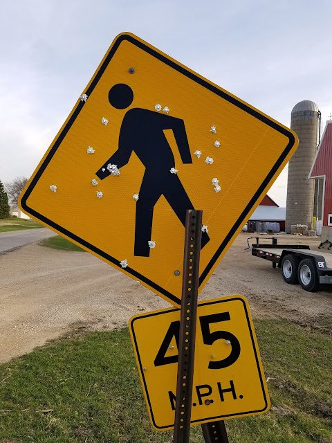
The first thing that crossed my mind was that as a pedestrian in these parts, I should take this as a warning to keep moving or else.
The second thing that occurred to me was that I was unaware that there was a speed limit for pedestrians. It didn't really matter, though. I can't walk 45 miles per hour even on the best of days.


We topped 1100 miles today. This is getting closer all the time.
Running Total: 1107.7 miles of trail covered, 156.1 miles 'extra' hiking/biking. End of Day 165.
No comments:
Post a Comment