Day 188: Connecting Route, Lincoln County
Day 188: Thursday, June 9th, 2022
Total Miles hiked for the day: 7.5; Net Miles 0.4
Location: The rest of the Connecting Route between the Grandfather Falls and Underdown Segments, starting at the intersection of South End Road and Tug Lake Avenue and ending at the Underdown trailhead.
7.5 Miles of trail covered
Another weekday, another road hike in Lincoln County.
I have to say it's been a little strange having places to hike that are so close to home. We've been driving two and three hours for so long just to get to a place where we could start walking that doing anything after work, even in the long, long days of summer, was preposterous.
But now that we're back to walking the roads that we biked in the past we suddenly have a while bunch of stuff relatively close to home.
So we were pretty happy about getting out night after night, chipping away at the road miles. Just this week we had already hiked off 10.9 miles, and we got another 7.5 done today.
Theresa dropped me off at the Underdown Segment to start our crisscross hike. There was a bicycle there belonging to someone who was obviously self-shuttling. We didn't get to meet them, but we left behind a snail patch anyway. Sort of a drive-by sliming.
I actually really liked this hike. Horn Lake Road is entirely gravel, and there is nice scenery as you go. Or maybe it was just the warm, sunny day that was raising my spirits.
Even gravel roads are prettier when the sun is shining.
The gravel only lasted for about two miles. Once we worked our way to County H we were on pavement again.
There are places to park along the road if you look for them.
And there are a whole lot of turtles out here doing their best to make more turtles. The female turtles (there is no special name for a female turtle - it's just a turtle) lay eggs all along the south-facing road banks where they can dig in the exposed sand and have their eggs warmed by the sun.
I didn't pay much attention to where we were taking our hops. Theresa just dropped me off wherever the last parking spot was, drove up to the next one and we hiked in opposite directions.
There are a lot of hills on this stretch of road. It bounces up and down usually in 30 to 50 foot increments, but occasionally there would be a real climb or a real drop, especially as it related to both ends of Pier Street. The last drop to Tug Lake is fairly steep and includes a railroad crossing.
Take it from someone who discovered the hard way. When you drive across those railroad tracks, SLOW DOWN. The locals take it at about 5 mph. 20 is too fast. 40 will cause damage. You could drop an axle at 50.
There's probably a story connected to this lost shoe. It's probably a sad story.
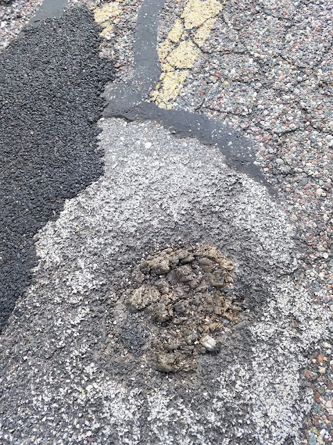
And as I was hiking along somewhere on Tug Lake Road I spotted this in the middle of the road.
That's a post. a wooden post. It was cut off at some point in the past and just paved over. I'm told that it was probably just the remnants of a fence line that marked an old property boundary, but still I'm thinking, with all the heavy equipment needed to grade and prep a paved road, couldn't they be bothered to remove an old post?
And then there was this old remnant of someone's dream of owning and farming a few acres. Today it's just a broken-down old pump that would still be working today if someone had bothered to put a little oil on the moving parts once in a while.
We just kept walking, and I just kept taking pictures of water every time I saw it, because every pond and creek looked so gorgeous today.
One of the last things I walked past was this purple martin condo, with its twin in the background.
When I got to Tug Lake Recreation Area for the last time, my hiking day was over. Theresa, who started from this point a little while ago, ran into another hiker by the name of Barb who was pleased to become an honorary Snail.
My last task was to pick Theresa up some little ways down the road.
I'm not sure what happened when I first logged this connecting route last April. I only logged 10.0 miles total when the real total was 10.4. That meant that when we hiked the true distance I got to add four tenths of a mile to our running total.
The tally:
- Two new Snail, we think.
- Completed maps 28 and 29
- Converted 7.1 miles of biking to the 'hiked' category
- Added 0.4 trail miles
- 184.3 miles to go
Running Total: 1212.6 miles of trail covered (952.7 hiked), 247.1 miles 'extra' hiking/biking. End of Day 188.


No comments:
Post a Comment